
Uzbekistan Google Maps is a site/tool that offers a wide range of map views (topographic, satellite, street view) and navigation options, with little effort on your part, yet efficiently. If you need to plan a trip to a new place like Uzbekistan, Google maps are available on desktop, mobile, or tablet. This Google maps and information page is dedicated to Uzbekistan, Asia (22 countries), showing its location, country facts, details about its capital city Tashkent (Toshkent), bordering countries like Afghanistan, Kazakhstan, Kyrgyzstan, Tajikistan, Turkmenistan, and plenty of other information which may be interesting when you visit this Asian state.
Quick links: Google Maps Uzbekistan, Tashkent Google maps, Driving Directions Uzbekistan, Printable Road Map.
About Uzbekistan in a nutshell
- The Aral Sea holds just a tenth of its former volume of water due to the diversion of rivers for irrigation.
- Conventional short form of the name: Uzbekistan
- The conventional long form of the name: Republic of Uzbekistan
- Local long form: Ozbekiston Respublikasi
- Local short form: Ozbekiston
- Former name(s): Uzbek Soviet Socialist Republic
- Etymology: a combination of the Turkic words uz (self) and bek (master) with the Persian suffix -stan (country) to give the meaning Land of the Free.
- The legal system in Uzbekistan: civil law system.
- Climate: Harsh continental climate. Summers can be extremely hot and dry; winters are cold.
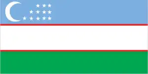
- The national symbols are khumo (mythical bird); national colors are blue, white, red, and green.
- Internet TLD: .uz
Central Asia’s “Mesopotamia”, which occupies the Amudarja-Syrdara river, is the former Soviet republic of almost five Magyar republics and has the richest history and the most World Heritage sites of all its neighbors. The Silk Road’s once glorious cities are now trying to fulfill their glorious role as a link between civilizations through tourism. In the 8th century, Khiva was already a caravan stop on one of the branches of the Silk Road to the Caspian Sea and the Volga. The turquoise city takes its name from the color of the tiles covering its minarets.
The ‘brown pearl’ of Turkestan, the fortress city of Buhara, also a World Heritage site founded over two thousand years ago, is the finest example of a medieval city in Central Asia, with its thousand-year-old buildings preserving the original urban structure almost intact. The oldest and most beautiful building in the trading town, which was established on the main route of the Silk Road, is the mausoleum of Ismail Samani, built in 905 AD. Founded in the 7th century AD, Samarkand has been a melting pot and crossroads of cultures throughout history and reached its heyday in the Timurid period, in the 14th-15th centuries. Its mosques, med-rasa, and observatory, richly covered with azure tiles and mosaics, make it a true jewel of the Silk Road. The unique monuments of the Old City of Shahrisabz, also a World Heritage Site, including the tomb of Timur, represent the architecture of the Timurid period from the 15th to the 16th centuries.
Background
Uzbekistan is the geographic and population center of Central Asia. The country has a diverse economy and a relatively young population. Russia conquered and united the disparate territories of present-day Uzbekistan in the late 19th century. Stiff resistance to the Red Army after the Bolshevik Revolution was eventually suppressed, and a socialist republic was established in 1924. During the Soviet era, intensive white gold (cotton) and grain production led to the overuse of agrochemicals and the depletion of water supplies, leaving the land degraded and the Aral Sea and certain rivers half-dry. Independent since the dissolution of the USSR in 1991, the country has diversified agricultural production while developing its mineral and petroleum export capacity and increasing its manufacturing base. However, cotton remains a significant part of its economy. Uzbekistan’s first president, Islam KARIMOV, led Uzbekistan for 25 years until his death in September 2016. His successor, former Prime Minister Shavkat MIRZIYOYEV, has improved relations with Uzbekistan’s neighbors and introduced wide-ranging economic, judicial, and social reforms.
Geography
Arid and semiarid plains in much of the west. Fertile, irrigated farmland in the east lies below the peaks of the western Pamirs.
Sharing what is left of the Aral Sea with neighboring Kazakhstan, Uzbekistan lies on the ancient Silk Road between Asia and Europe. It is the most populous central Asian republic.
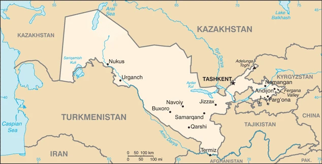
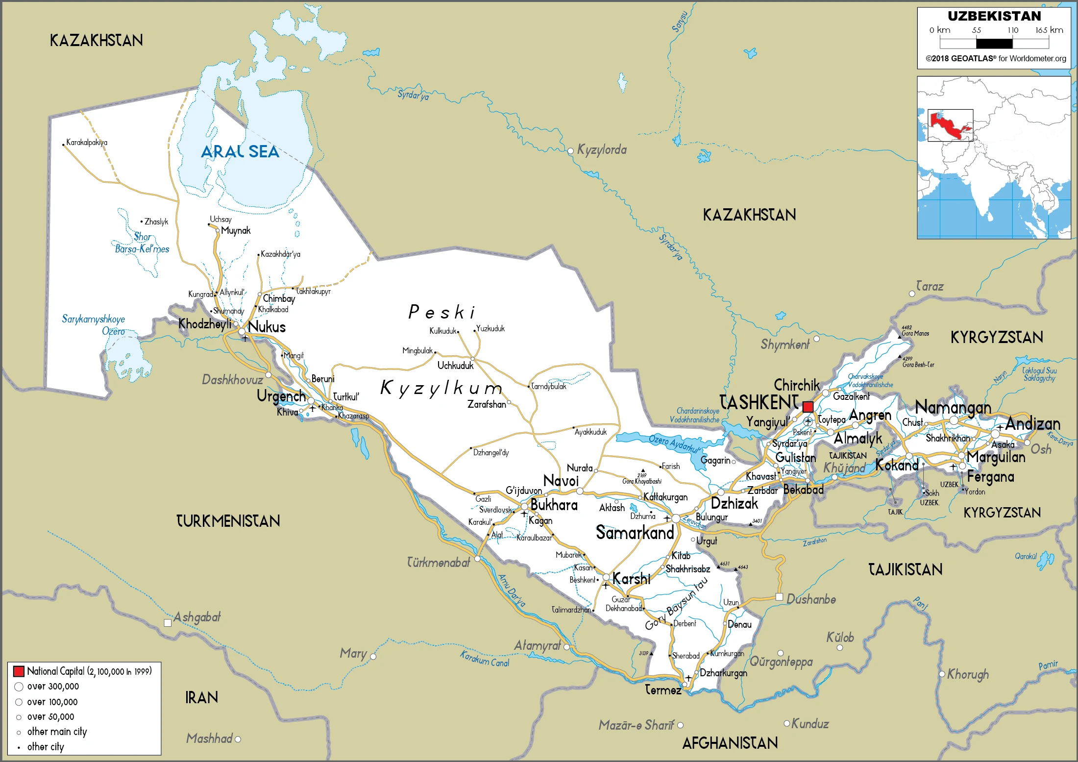
This state is located in Central Asia, north of Turkmenistan, south of Kazakhstan, under the coordinates of 41 00 N, 64 00 E, covering an area of 447,400 sq km with a coastline of 0 km (landlocked country). Uzbekistan is About four times the size of Virginia, slightly larger than California.
Uzbekistan has 6,893 km of land boundaries in total and bordering with (5 nations): Afghanistan 144 km, Kazakhstan 2330 km, Kyrgyzstan 1314 km, Tajikistan 1312 km, Turkmenistan 1793 km.
Mostly flat-to-rolling sandy desert with dunes, broad, flat, intensely irrigated river valleys along the course of Amu Darya, Syr Darya (Sirdaryo), and Zarafshon, Fergana valley in the east, surrounded by mountainous Tajikistan and Kyrgyzstan, Shrinking Aral sea in the west, with Adelunga Toghi 4,301 m as the highest point of Uzbekistan, while Sariqamish Kuli -12 m as the lowest point, causing a mean elevation at N/A throughout the country. With a total of 447,400 sq km, Uzbekistan has 425,400 sq km of land and 22,000 sq km of water surface area.
Major water bodies in the country: Aral Sea (shared with Kazakhstan) – largely dried up (a freshwater lake), while the major rivers are: Syr Darya (shared with Kyrgyzstan, Kazakhstan, and Tajikistan) – 3,078 km, Amu Darya (shared with Turkmenistan, Tajikistan, and Afghanistan) – 2,620 km. The significant watersheds for Uzbekistan are Internal (endorheic basin) drainage: (Aral Sea basin), Amu Darya (534,739 sq km), and Syr Darya (782,617 sq km).
Along with Liechtenstein, Uzbekistan is one of the world’s only two doubly landlocked countries.
The climate in Uzbekistan is as follows: Mostly mid-latitude desert, long, hot summers, mild winters, and semiarid grassland in the east.
When you visit Uzbekistan, the natural hazards shall be considered: Earthquakes, floods; landslides or mudslides; avalanches; droughts.
The following major health-threatening issues shall be considered when visiting Uzbekistan: none.
Current environmental issues affecting the Uzbekistani people: shrinkage of the Aral Sea has resulted in growing concentrations of chemical pesticides and natural salts; these substances are then blown from the increasingly exposed lake bed and contribute to desertification and respiratory health problems; water pollution from industrial wastes and the heavy use of fertilizers and pesticides is the cause of many human health disorders; increasing soil salination; soil contamination from buried nuclear processing and agricultural chemicals, including DDT.
Google Maps Uzbekistan
The capital and other divisions
Capital city: Tashkent (Toshkent) found under the coordinates 41 19 N, 69 15 E, applying the time zone UTC+5 (10 hours ahead of Washington, DC, during Standard Time), using the following daylight saving time: none.
Tashkent is the capital city of Uzbekistan and is located in the center of this country, on the banks of the Syrdarya River. Tashkent has a population of about 2 million people. It’s known for its bazaars, which are filled with goods from all over Asia and Central Asia. It is an economic hub for the country and has a diverse population. It has been designated a UNESCO world heritage site, which is one of many reasons people are drawn to visit this place.
Uzbekistan became independent on 1 September 1991 (from the Soviet Union), and its national holiday is Independence Day, 1 September (1991).
Administrative divisions: 12 provinces (viloyatlar, singular – viloyat), 1 autonomous republic (avtonom respublikasi), and 1 city (Shahar); Andijon Viloyati, Buxoro Viloyati Bukhara Province, Fargona Viloyati Fergana Province, Jizzax Viloyati, Namangan Viloyati, Navoiy Viloyati, Qashqadaryo Viloyati (Qarshi), Qoraqalpogiston Respublikasi Karakalpakstan Republic (Nukus), Samarqand Viloyati Samarkand Province, Sirdaryo Viloyati (Guliston), Surxondaryo Viloyati (Termiz), Toshkent Shahri Tashkent City, Toshkent Viloyati Tashkent Province, Xorazm Viloyati (Urganch).
People and society
Complex ethnic makeup. Ex-Communists are in firm control, but traditional social patterns based on clan, religion, and region have reemerged. Constitutional measures aim to control the influence of Islam: activities against Islamists have drawn international condemnation. Most people live in the fertile east. Birth rates are high, and the status of women continues to be low.
The population in Uzbekistan is 30,842,796 (July 2021 estimate), with an average of 0.86% (2021 estimate) change. That means Uzbekistan is the No. 47 in the world’s populated rank list. With an average of 30.1 years (29.4 years for males and 29.4 years for women), Uzbekistan ranks No. 123 on the globe’s median age rank list.
The people living in this country are the Uzbekistani (noun) or Uzbekistani (adjective) and belong mainly to the following ethnic groups: Uzbek 83.8%, Tajik 4.8%, Kazakh 2.5%, Russian 2.3%, Karakalpak 2.2%, Tatar 1.5%, other 4.4% (2017 estimate).
They speak Uzbek (official language) 74.3%, Russian 14.2%, Tajik 4.4%, other 7.1% languages and practice the following religions: Muslim 88% (predominantly Sunni), Eastern Orthodox 9%, other 3%.
We can conclude the following about the population in Uzbekistan: Most of the population is concentrated in the fertile Fergana valley in the easternmost arm of the country. The south has significant clusters of people, while the central and western deserts are sparsely populated. In Uzbekistan, we are talking about 50.4% (2021) of the total population living in cities, and most of them reside in the following municipalities: 2.545 million, Tashkent (capital city) (2021).
Industry
Highly regulated. Reserves of natural gas, oil, coal, gold (one of the worlds largest gold mines), and other minerals. The cash crop is cotton: which requires much irrigation. Grain imports are necessary.
Uzbekistan is a doubly landlocked country in which 51% of the population lives in urban settlements; the agriculture-rich Fergana Valley, where Uzbekistan’s eastern borders are situated, has been counted among the most densely populated parts of Central Asia. Since its independence in September 1991, the government has largely maintained its Soviet-style command economy with subsidies and tight controls on production, prices, and access to foreign currency. Despite ongoing efforts to diversify crops, Uzbek agriculture remains primarily centered on cotton; Uzbekistan is the world’s fifth-largest cotton exporter and seventh-largest producer. Uzbekistan’s growth has been driven primarily by state-led investments, and the export of natural gas, gold, and cotton provides a significant share of foreign exchange earnings., Lower global commodity prices and economic slowdowns in neighboring Russia and China have recently hurt Uzbekistan’s trade and investment and worsened its foreign currency shortage.
Aware of the need to improve the investment climate, the government is taking incremental steps to reform the business sector and address impediments to foreign investment. Since the death of first President Islam KARIMOV and the election of President Shavkat MIRZIYOYEV, emphasis on such initiatives and government efforts to improve the private sector has increased. In the past, Uzbek authorities accused the US and other foreign companies operating in Uzbekistan of violating Uzbek laws and have frozen and seized their assets., As a part of its economic reform efforts, the Uzbek Government is looking to expand opportunities for small and medium enterprises and prioritizes increasing foreign direct investment. In September 2017, the government devalued the official currency rate by almost 50%. It announced loosening currency restrictions to eliminate the black currency market, increase access to hard currency, and boost investment.
Uzbekistan is rich in the following natural resources: Natural gas, petroleum, coal, gold, uranium, silver, copper, lead, and zinc, tungsten, molybdenum.
The main industrial sectors are textiles, food processing, machine building, metallurgy, mining, hydrocarbon extraction, and chemicals.
The country’s export sectors are robust in gold, natural gas, cotton fibers, copper, and ethylene polymers (2019), partnering with these nations: Switzerland 19%, the United Kingdom 17%, Russia 15%, China 14%, Kazakhstan 9%, Turkey 8%, Kyrgyzstan 5% (2019). The export trade resulted in $14.52 billion. Note: Data are in current year dollars (2020 estimate). In a global rank of export, values resulted in Uzbekistan’s position of 92.
Land use in Uzbekistan: 7.7% (2018 estimate) forest, 29.7% (2018 estimate) other.
The arable land area is 10.1% (2018 estimate), and the agricultural land is 62.6% (2018 estimate). Land use for permanent crops 0.8% (2018 estimate), permanent pasture 51.7% (2018 estimate). The sum of the area of the irrigated land is 42,150 sq km (2012).
The main agro-industrial products of Uzbekistan are milk, wheat, potatoes, carrots/turnips, cotton, tomatoes, vegetables, grapes, onions, and watermelons.
The country typically needs to import: cars and vehicle parts, packaged medicines, refined petroleum, aircraft, and construction vehicles (2019), partnering with the following nations: China 23%, Russia 18%, South Korea 11%, Kazakhstan 9%, Turkey 6%, Germany 5% (2019) in a sum value of $22.56 billion. Note: data are in current year dollars (2020 estimate) $26.55 billion. Note: data are in current year dollars (2019 estimate) $23.44 billion. Note: data are in current year dollars (2018 estimate). This sum value on the global ranking list of imports resulted in Uzbekistan 78.
Uzbekistan Driving Directions
In this post, you learned about Uzbekistan, Central Asia, north of Turkmenistan, and south of Kazakhstan. We published some basic information about its capital Tashkent (Toshkent), and the Uzbekistani nation.
Are you interested in visiting Uzbekistan and looking for driving directions? Click here to plan your route, or see a printable road map of Uzbekistan below for an overview of the route network.
Printable map of Uzbekistan
Did you know about Uzbekistan?
Although Uzbekistan is a landlocked country, it has access to the sea through the Aral Sea. The country is also home to the giant Ferris wheel in the world, located in Tashkent. Uzbekistan’s landscape is mostly desert, with mountains in the east and west. Despite this, agriculture is an integral part of the economy, and cotton is one of the main crops grown.
After virtually visiting Uzbekistan, you may also be interested in the neighboring countries: Afghanistan, Kazakhstan, Kyrgyzstan, Tajikistan, and Turkmenistan.
If you liked our Google map and Uzbekistan information page,
please share it with others or save the link https://www.drivingdirections.net in your bookmarks.