
British Virgin Islands Google Maps is a site/tool that offers a wide range of map views (topographic, satellite, street view) and navigation options, with little effort on your part, yet efficiently. If you need to plan a trip to a new place like the British Virgin Islands, Google maps are available on desktop, mobile, or tablet. This Google maps and information page is dedicated to the British Virgin Islands, Central America, and the Caribbean (35 countries), showing its location, country facts, details about its capital city Road Town, bordering countries like none, and plenty of other information which may be interesting when you visit this Central American and the Caribbean state.
Quick links: Google Maps British Virgin Islands, Road Town Google maps, Driving Directions British Virgin Islands, Printable Road Map.
About British Virgin Islands in a nutshell
- Conventional short form of the name: British Virgin Islands
- The conventional long form of the name: none
- Etymology: the myriad islets, cays, and rocks surrounding the major islands reminded explorer Christopher COLUMBUS in 1493 of Saint Ursula and her 11,000 virgin followers (Santa Ursula y las Once Mil Virgenes), which over time shortened to the Virgins (las Virgenes).
- The legal system in British Virgin Islands: English common law.
- Climate: N/A
- The national symbols are zenaida dove, white cedar flower; national colors: yellow, green, red, white, blue.
- Internet TLD: .vg
Background
First inhabited by Arawak and later by Carib Indians, the Virgin Islands were settled by the Dutch in 1648 and then annexed by the English in 1672. The islands were part of the British colony of the Leeward Islands from 1872 to 1960. They were granted autonomy in 1967. The economy is closely tied to the West’s more extensive and populous US Virgin Islands. The US dollar is the legal currency. On 6 September 2017, Hurricane Irma devastated the island of Tortola. An estimated 80% of residential and business structures were destroyed or damaged, communications disrupted, and local roads rendered impassable.
Geography
The British Virgin Islands is a British overseas territory in the Caribbean, consisting of more than 100 islands and cays.
This state is located in the Caribbean, between the Caribbean Sea and the North Atlantic Ocean, east of Puerto Rico, under the coordinates of 18 30 N, 64 30 W, covering an area of 151 sq km with a coastline of 80 km. British Virgin Islands is About 0.9 times the size of Washington, DC.
The British Virgin Islands has 0 km of land boundaries.
Coral islands are relatively flat, volcanic islands steep, hilly, with Mount sage 521 m as the highest point of the British Virgin Islands. The Caribbean Sea 0 m is the lowest point, causing a mean elevation at N/A throughout the country. With a total of 151 sq km, the British Virgin Islands has 151 sq km of land and 0 sq km water surface area.
Strong ties to nearby US Virgin Islands and Puerto Rico
The climate in the British Virgin Islands is as follows: Subtropical, humid, temperatures moderated by trade winds.
When you visit the British Virgin Islands, the natural hazards are hurricanes and tropical storms (July to October).
The following major health-threatening issues shall be considered when visiting the British Virgin Islands: none.
Current environmental issues affecting the British Virgin Islander people: limited natural fresh water resources except for a few seasonal streams and springs on Tortola; most of the island’s water supply comes from desalination plants; sewage and mining/industry waste contribute to water pollution, threatening coral reefs.
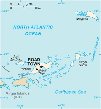
Google Maps British Virgin Islands
The capital and other divisions
Capital city: Road Town found under the coordinates 18 25 N, 64 37 W, applying the time zone UTC-4 (1 hour ahead of Washington, DC, during Standard Time), using the following daylight saving time: none.
Road Town is a small town on the island of Tortola in the British Virgin Islands. It has a population of around 3000 people and is located on the main highway that connects Road Town to Tortola’s capital, Road Town. The town was named for its geographical location.
British Virgin Islands became independent on none (Overseas Territory of the UK), and its national holiday is Territory Day, 1 July (1956).
Administrative divisions: none (overseas territory of the UK).
People and society
The population in the British Virgin Islands is 37,891 (July 2021 estimate), with an average of 1.96% (2021 estimate) change. That means the British Virgin Islands is the No. 213 in the world’s populated rank list. With an average of 37.2 years median age (37 years for males and 37 years for women), the British Virgin Islands ranks No. 71 on the globe’s median age rank list.
The people living in this country are the British Virgin Islander(s) (noun) or British Virgin Islander (adjective) and belong mainly to the following ethnic groups: African/Black 76.3%, Latino 5.5%, White 5.4%, mixed 5.3%, Indian 2.1%, East Indian 1.6%, other 3%, unspecified 0.8% (2010 estimate).
They speak English (official language) languages and practice the following religions: Protestant 70.2% (Methodist 17.6%, Church of God 10.4%, Anglican 9.5%, Seventh Day Adventist 9.0%, Pentecostal 8.2%, Baptist 7.4%, New Testament Church of God 6.9%, other Protestant 1.2%), Roman Catholic 8.9%, Jehovahs Witness 2.5%, Hindu 1.9%, other 6.2%, none 7.9%, unspecified 2.4% (2010 estimate).
We can conclude the following about the population in the British Virgin Islands: A fairly even distribution throughout the inhabited islands, with the largest islands of Tortola, Anegada, Virgin Gorda, and Jost van Dyke having the largest populations. In the British Virgin Islands, we are talking about 48.9% (2021) of the total population is living in cities, and most of them reside in the following municipalities: 15,000 Road Town (capital city) (2018).
Industry
One of the most stable and prosperous in the Caribbean, the economy is highly dependent on tourism, which generates an estimated 45% of the national income. More than 934,000 tourists, mainly from the US, visited the islands in 2008. Because of traditionally close links with the US Virgin Islands, the British Virgin Islands have used the US dollar since 1959. Livestock raising is the most important agricultural activity; poor soils limit the island’s ability to meet domestic food requirements.
In the mid-1980s, the government began offering offshore registration to companies wishing to incorporate in the islands, and incorporation fees now generate substantial revenues. Roughly 400,000 companies were on the offshore registry by yearend 2000. The adoption of comprehensive insurance law in late 1994, which provides a blanket of confidentiality with regulated statutory gateways for investigation of criminal offenses, made the British Virgin Islands even more attractive to international business.
The British Virgin Islands is rich in natural resources: Pleasant climate beaches foster tourism.
The main industrial sectors are tourism, light industry, construction, rum, concrete block, offshore banking center.
The country’s export sectors are particularly strong in recreational boats, aircraft, diamonds, paintings, precious stones (2019), partnering with these nations: Malta 30%, Seychelles 29%, Switzerland 14% (2019). The export trade resulted in $23 million. Note: Data are in current year dollars (2017 estimate). In a global rank of the export, values resulted in the British Virgin Islands’s position of 217.
Land use in the British Virgin Islands: 24.3% (2018 estimate) forest, 29% (2018 estimate) other.
The arable land area is 6.7% (2018 estimate), and the agricultural land is 46.7% (2018 estimate). Land use for permanent crops 6.7% (2018 estimate), permanent pasture 33.3% (2018 estimate).
The main agro-industrial products of the British Virgin Islands are fruits, vegetables, livestock, poultry, fish.
The country typically needs to import: recreational boats, aircraft, refined petroleum, cars, furniture (2019), partnering with the following nations: Germany 32%, United States 22%%, Italy 9%, France 7%, Seychelles 7% (2019) in a sum value of $300 million NA (2017 estimate) $210 million (2016 estimate). This sum value on the global ranking list of imports resulted in British Virgin Islands 210.
British Virgin Islands Driving Directions
In this post, you learned about the British Virgin Islands, Caribbean, between the Caribbean Sea and the North Atlantic Ocean, east of Puerto Rico. We published some basic information about its capital, Road Town, and the British Virgin Islander nation.
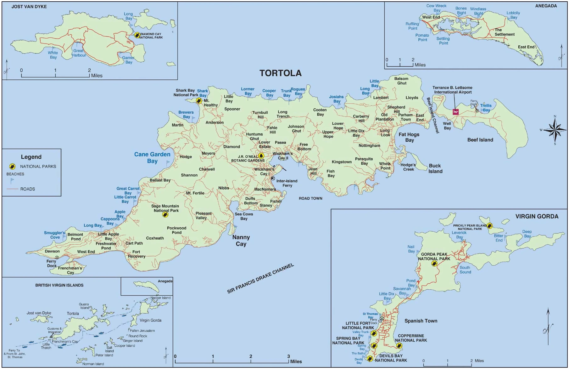
Are you interested in visiting the British Virgin Islands and looking for driving directions? Click here to plan your route, or see a printable road map of the British Virgin Islands below for an overview of the route network.
Printable map of British Virgin Islands
Did you know about British Virgin Islands?
This country is the most “British” of all the Caribbean islands. It’s also one of the most beautiful, with turquoise waters and white sandy beaches. The islands are part of the Leeward Islands in the northern part of the Lesser Antilles.
It’s surrounded by the Atlantic Ocean and has its self-governing internal affairs. Because of this, some customs are different from the UK. For example, if you have relatives who live abroad, you can get a visa to stay in the BVI for six months.
After virtually visiting the British Virgin Islands, you may also be interested in the US Virgin Islands, the United Kingdom, and Seychelles.
If you liked our Google map and British Virgin Islands information page,
please share it with others or save the link https://www.drivingdirections.net in your bookmarks.