
Estonia Google Maps is a site/tool that offers a wide range of map views (topographic, satellite, street view) and navigation options, with little effort on your part, yet efficiently. If you need to plan a trip to a new place like Estonia, Google maps are available on desktop, mobile, or tablet. This Google maps and information page is dedicated to Estonia, Europe (47 countries), showing its location, country facts, details about its capital city Tallinn, bordering countries like Latvia, Russia, and plenty of other information which may be interesting when you visit this European state.
Quick links: Google Maps Estonia, Tallinn Google maps, Driving Directions Estonia, Printable Road Map.
About Estonia in a nutshell
- Conventional short form of the name: Estonia
- The conventional long form of the name: Republic of Estonia
- Local long form: Eesti Vabariik
- Local short form: Eesti
- Former name(s): Estonian Soviet Socialist Republic
- Etymology: the country name may derive from the Aesti, an ancient people who lived along the eastern Baltic Sea in the first centuries A.D..
- The legal system in Estonia: civil law system.
- Climate: Maritime, with some continental extremes. Harsh winters, with cool summers and damp springs.
- The national symbols are barn swallow, cornflower; national colors: blue, black, white.
- Internet TLD: .ee
The Baltic republics are among Europe’s youngest states – they regained their independence in 1991 after half a century of Soviet rule, and all three became EU member states in 2004. They have much in common regarding their geography and history, but each has its own ‘individuality’. Estonia does not seem to have been spoilt by nature with diversity. At its highest point, Suur Munamági in the south-eastern corner of the country, rising from a moraine moraine moraine lagoon on glacial glaciers, is only 318 meters above its marshland and swamp forest surroundings. Due to its distance from the ocean, its cool and humid climate sometimes amplifies the influence of the land. In winter, the sea around the islands freezes over for three months.
Half of the country is covered by forest and about a quarter is marshland. On the Russian border, Lake Peipsi (Chud) is Europe’s fourth-largest lake. The ancestors of the Baltic Finns lived here as early as the 3rd millennium BC; they mixed with Baltic and Germanic elements, and in the 1st millennium AD, the Estonian ethnic group was formed. After Danish, Swedish, German and Russian conquests and half a century of Soviet rule, Estonia regained its independence in 1991, having first won it in 1918. The capital, Tallinn, founded in the 13th century around the castle of the German crusaders, became one of the leading centers of the Hanseatic League, and its medieval Old Town, which still preserves its medieval image, is now a World Heritage Site. The Struve surveying network also passed through Estonia.
Estonia pioneered online voting in 2007 and voting by cell phone in 2011.
Background
After centuries of Danish, Swedish, German, and Russian rule, Estonia attained independence in 1918. Forcibly incorporated into the USSR in 1940 – an action never recognized by the US and many other countries – it regained its freedom in 1991 with the collapse of the Soviet Union. Since the last Russian troops left in 1994, Estonia has been free to promote economic and political ties with the West. It joined both NATO and the EU in the spring of 2004, formally joined the OECD in late 2010, and adopted the euro as its official currency on 1 January 2011.
Geography
Estonias terrain is flat, boggy, and partly forested, with over 1500 islands. Lake Peipus forms much of the eastern border with Russia.
The smallest and most Western-oriented of the former Soviet-ruled Baltic states, Estonia is also the most developed, but its standard of living is well below the EU average.
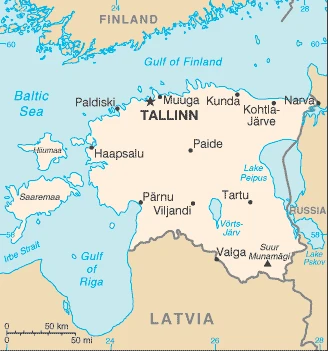
This state is located in Eastern Europe, bordering the Baltic Sea and the Gulf of Finland, between Latvia and Russia, under the coordinates of 59 00 N, 26 00 E, covering an area of 45,228 sq km with a coastline of 3,794 km. Estonia is About twice the size of New Jersey.
Estonia has 657 km of land boundaries and borders with (2 nations): Latvia 333 km, Russia 324 km.
Marshy, lowlands, flat in the north, hilly in the south, with Suur Munamagi 318 m as the highest point of Estonia, while Baltic Sea 0 m as the lowest point, causing a mean elevation at 61 m throughout the country. With a total of 45,228 sq km, Estonia has 42,388 sq km of land and 2,840 sq km water surface area.
The mainland terrain is flat, boggy, and partly wooded; offshore lie more than 1,500 islands.
The climate in Estonia is as follows: Maritime, wet, moderate winters, cool summers.
The natural hazards shall be considered when you visit Estonia: Sometimes flooding occurs in the spring.
The following major health-threatening issues shall be considered when visiting Estonia: degree of risk: intermediate (2020), tick-borne encephalitis.
Current environmental issues affecting the Estonian people: air polluted with sulfur dioxide from oil-shale burning power plants in the northeast; however, the amounts of pollutants emitted to the air have fallen dramatically, and the pollution load of wastewater at purification plants has decreased substantially due to improved technology and environmental monitoring; Estonia has more than 1,400 natural and artificial lakes, the smaller of which in agricultural areas need to be monitored; coastal seawater is polluted in specific locations.
Google Maps Estonia
The capital and other divisions
Capital city: Tallinn found under the coordinates 59 26 N, 24 43 E, applying the time zone UTC+2 (7 hours ahead of Washington, DC, during Standard Time), using the following daylight saving time: +1hr begins last Sunday in March; ends last Sunday in October.
Tallinn, Estonia, is a city in northern Europe. It is one of the oldest and best-preserved medieval cities in the Baltic region, renowned for its medieval architecture and lively Old Town, with many brick gables and cobbled streets.
Estonia became independent on 24 February 1918 (from Soviet Russia); 20 August 1991 (declared from the Soviet Union); 6 September 1991 (recognized by the Soviet Union), and its national holiday is Independence Day, 24 February (1918).
Administrative divisions: 15 urban municipalities (linnad, singular – linn), 64 rural municipalities (vallad, singular vald) urban municipalities: Haapsalu, Keila, Kohtla-Jarve, Loksa, Maardu, Narva, Narva-Joesuu, Paide, Parnu, Rakvere, Sillamae, Tallinn, Tartu, Viljandi, Voru rural municipalities: Alutaguse, Anija, Antsla, Elva, Haademeeste, Haljala, Harku, Hiiumaa, Jarva, Joelahtme, Jogeva, Johvi, Kadrina, Kambja, Kanepi, Kastre, Kehtna, Kihnu, Kiili, Kohila, Kose, Kuusalu, Laane-Harju, Laane-Nigula, Laaneranna, Luganuse, Luunja, Marjamaa, Muhu, Mulgi, Mustvee, Noo, Otepaa, Peipsiaare, Pohja-Parnumaa, Pohja-Sakala, Poltsamaa, Polva, Raasiku, Rae, Rakvere, Räpina, Rapla, Rouge, Ruhnu, Saarde, Saaremaa, Saku, Saue, Setomaa, Tapa, Tartu, Toila, Tori, Torva, Turi, Vaike-Maarja, Valga, Viimsi, Viljandi, Vinni, Viru-Nigula, Vormsi, Voru.
People and society
Estonians are related ethnically and linguistically to the Finns. Friction between ethnic Estonians and the significant Russian minority led to a reassertion of Estonian culture and language. Outright discrimination against the Russian language was only ended in 2000. Estonians are predominantly Lutheran. Families are small. The divorce rate has reduced since the 1980s peak. Market reforms have increased prosperity; a few people have become very rich.
The population in Estonia is 1,220,042 (July 2021 estimate), with an average of -0.69% (2021 estimate) change. That means Estonia is the No. 159 in the world’s populated rank list. With an average of 43.7 years median age (40.4 years for males and 40.4 years for women), Estonia ranks No. 21 on the globe’s median age rank list.
The people living in this country are the Estonian(s) (noun) or Estonian (adjective) and belong mainly to the following ethnic groups: Estonian 68.7%, Russian 24.8%, Ukrainian 1.7%, Belarusian 1%, Finn 0.6%, other 1.6%, unspecified 1.6% (2011 estimate).
They speak Estonian (official language) 68.5%, Russian 29.6%, Ukrainian 0.6%, other 1.2%, unspecified 0.1% (2011 estimate) languages and practice the following religions: Orthodox 16.2%, Lutheran 9.9%, other Christian (including Methodist, Seventh Day Adventist, Roman Catholic, Pentecostal) 2.2%, other 0.9%, none 54.1%, unspecified 16.7% (2011 estimate).
We can conclude the following about the population in Estonia: A fairly even distribution throughout most of the country, with urban areas attracting larger and denser populations. In Estonia, we are talking about 69.4% (2021) of the total population is living in cities, and most of them reside in the following municipalities: 449,000 Tallinn (capital city) (2021).
Industry
Timber and oil shale. Good productivity. Strong growth accompanied EU accession in 2004, but the first EU country to enter recession in 2008. Drastic spending cuts aided quick revival. Joined eurozone in 2011. Low debt burden.
Estonia, a member of the EU since 2004 and the eurozone since 2011, has a modern market-based economy and one of the higher per capita income levels in Central Europe and the Baltic region. Still, its economy depends on trade, making it vulnerable to external shocks. Estonia’s successive governments have pursued a free market, pro-business economic agenda, and sound fiscal policies that have resulted in balanced budgets and the lowest debt-to-GDP ratio in the EU. The economy benefits from robust electronics and telecommunications sectors and strong trade ties with Finland, Sweden, Germany, and Russia.
The economy’s 4.9% GDP growth in 2017 was the fastest in the past six years, leaving the Estonian economy in its best position since the financial crisis 10 years ago. For the first time in many years, labor productivity increased faster than labor costs in 2017. Inflation also rose in 2017 to 3.5% alongside increased global prices for food and energy, which make up a large share of Estonia’s consumption. Estonia is challenged by a shortage of labor, both skilled and unskilled. However, the government has amended its immigration law to allow easier hiring of highly qualified foreign workers and wage growth that outpaces productivity gains. The government is also pursuing efforts to boost productivity, focusing on innovations emphasizing technology start-ups and e-commerce.
Estonia is rich in the following natural resources: Oil shale, peat, rare earth elements, phosphorite, clay, limestone, sand, dolomite, arable land, sea mud.
The main industrial sectors are food, engineering, electronics, wood and wood products, textiles, information technology, telecommunications.
The country’s export sectors are robust in broadcasting equipment, refined petroleum, coal tar oil, cars, prefabricated buildings (2019), partnering with these nations: Finland 13%, Sweden 9%, Latvia 8%, Russia 8%, United States 7%, Lithuania 6%, Germany 6% (2019). The export trade resulted in $21.69 billion. Note: Data are in current year dollars (2020 estimate). In a global rank of the export, values resulted in Estonia’s position of 78.
Land use in Estonia: 52.1% (2018 estimate) forest, 25.7% (2018 estimate) other.
The arable land area is 14.9% (2018 estimate), and the agricultural land is 22.2% (2018 estimate). Land use for permanent crops 0.1% (2018 estimate), permanent pasture 7.2% (2018 estimate). The sum of the area of the irrigated land is 40 sq km (2012).
The main agro-industrial products of Estonia are wheat, milk, barley, rapeseed, rye, oats, peas, potatoes, pork, triticale.
The country typically needs to import: cars, refined petroleum, coal tar oil, broadcasting equipment, packaged medicines (2019), partnering with the following nations: Russia 12%, Germany 10%, Finland 9%, Lithuania 7%, Latvia 7%, Sweden 6%, Poland 6%, China 6% (2019) in a sum value of $21.73 billion. Note: data are in current year dollars (2020 estimate) $21.68 billion. Note: data are in current year dollars (2019 estimate) $21.89 billion. Note: data are in current year dollars (2018 estimate). This sum value on the global ranking list of imports resulted in Estonia 80.
Estonia Driving Directions
In this post, you learned about Estonia, Eastern Europe, bordering the Baltic Sea and the Gulf of Finland, between Latvia and Russia. We published some basic information about its capital Tallinn, and the Estonian nation.
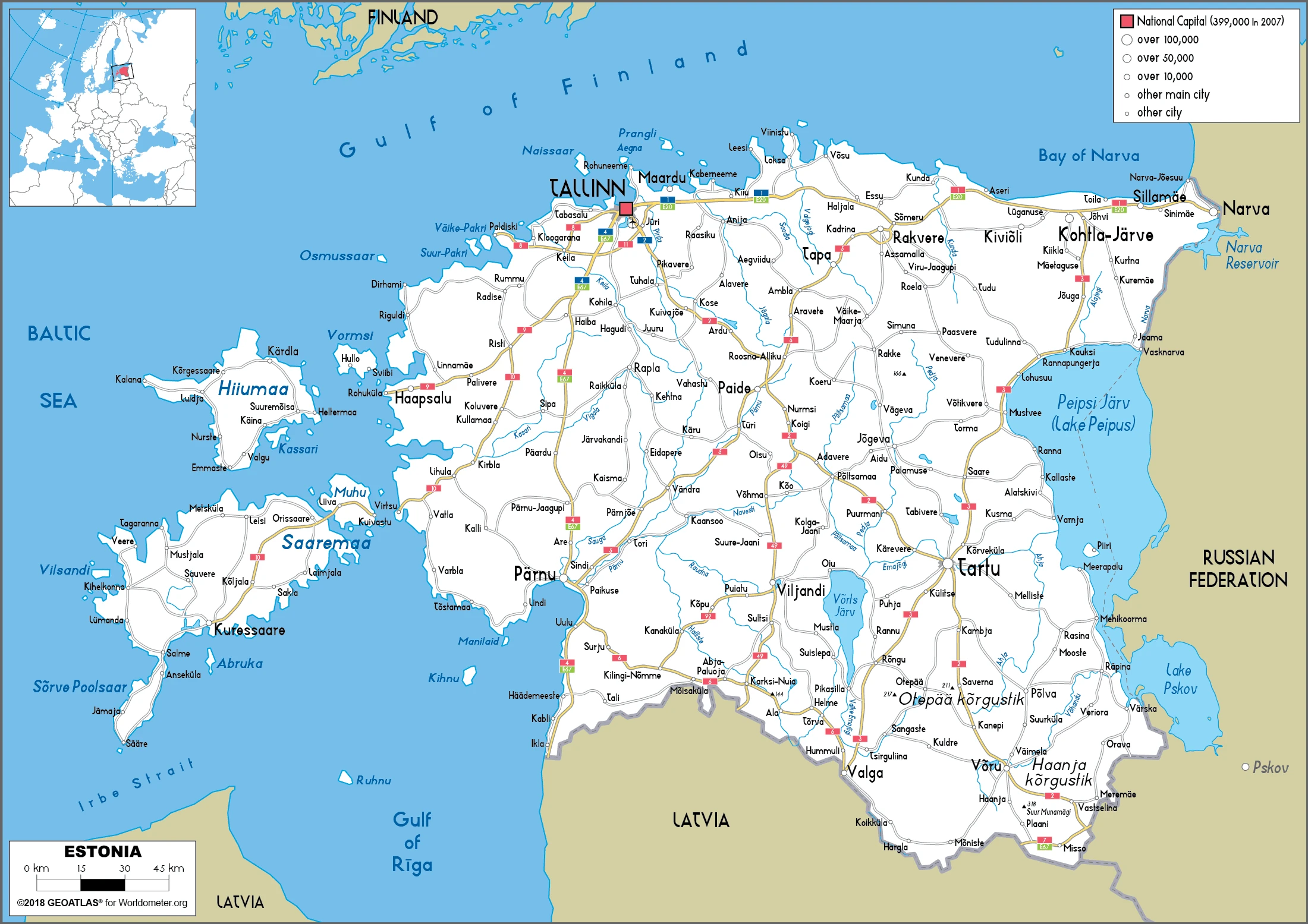
Are you interested in visiting Estonia and looking for driving directions? Click here to plan your route, or see a printable road map of Estonia below for an overview of the route network.
Printable map of Estonia
Did you know about Estonia?
Estonia is a small country located in Northern Europe. It has 1.3 million people, making it one of the most densely populated countries globally, with a population density of 135 people per square kilometer. Most Estonians are ethnic Estonians, and many speak the Estonian language, but Russian is also commonly spoken.
Its history dates back to medieval times when it was founded as an independent state in 1918 with around one million people. Estonia became a republic after World War II and joined the European Union in 2004. Estonia is known for having many advancements in science, technology, and medicine.
After virtually visiting Estonia, you may also be interested in the neighboring countries: Latvia, Russia.
If you liked our Google map and Estonia information page,
please share it with others or save the link https://www.drivingdirections.net in your bookmarks.