
Guinea Google Maps is a site/tool that offers a wide range of map views (topographic, satellite, street view) and navigation options, with little effort on your part, yet efficiently. If you need to plan a trip to a new place like Guinea, Google maps are available on desktop, mobile, or tablet. This Google maps and information page is dedicated to Guinea, Africa (54 countries), showing its location, country facts, details about its capital city Conakry, bordering countries like Côte d’Ivoire, Guinea-Bissau, Liberia, Mali, Senegal, Sierra Leone, and plenty of other information which may be interesting when you visit this African state.
Quick links: Google Maps Guinea, Conakry Google maps, Driving Directions Guinea, Printable Road Map.
About Guinea in a nutshell
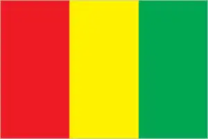
- The colors of Guineas flag represent the three words of the countrys motto: work (red), justice (yellow), and solidarity (green).
- Conventional short form of the name: Guinea
- The conventional long form of the name: Republic of Guinea
- Local long form: Republique de Guinee
- Local short form: Guinee
- Former name(s): French Guinea
- Etymology: the country is named after the Guinea region of West Africa that lies along the Gulf of Guinea and stretches north to the Sahel.
- The legal system in Guinea: civil law system based on the French model.
- Climate: Tropical, with a wet season April October. Conakry is especially rainy. Hot, dry harmattan wind blows from Sahara during dry season.
- The national symbols are elephant; national colors: red, yellow, green.
- Internet TLD: .gn
Background
Guineas’ deep Muslim heritage arrived via the neighboring Almoravid Empire in the 11th century. Following Almoravid’s decline, Guinea existed on the fringe of several African kingdoms competing for regional dominance. In the 13th century, the Mali Empire took control of Guinea, encouraging its already growing Muslim faith. After the fall of the West African empires, various smaller kingdoms controlled Guinea. In the 18th century, Fulani Muslims established an Islamic state in central Guinea that represents one of the earliest examples of a written constitution and alternating leadership. While European traders first arrived in the 16th century, the French secured colonial rule in the 19th century. In 1958, Guinea became independent from France, and Sekou TOURE established an authoritarian regime.
TOURE ruled until he died in 1984. After TOUREs death, General Lansana CONTE staged a coup and seized the government. CONTE organized and won presidential elections in 1993, 1998, and 2003. Upon CONTEs death in December 2008, Captain Moussa Dadis CAMARA led a military coup, seized power, and suspended the constitution. In September 2009, presidential guards opened fire on an opposition rally, killing more than 150 people. In early December 2009, CAMARA was wounded in an assassination attempt and exiled to Burkina Faso. In 2010 and 2013, the country held its first free and fair presidential and legislative elections. Alpha CONDE won the 2010 and 2015 presidential elections. Conde’s first cabinet was the first all-civilian government in Guinean history. In March 2020, Guinea passed a constitutional referendum that extended presidential terms and reset Conde’s term count, and later that year, Alpha CONDE won a controversial third presidential term. On 5 September 2021, Col Mamady DOUMBOUYA led a military coup by a National Committee of Rally and Development that arrested President CONDE, suspended the constitution, and dissolved the government. DOUMBOUYA was declared president on 17 September 2021. A charter of transition, issued in late September, made DOUMBOUYA transitional president for an undefined period, and on 1 October 2021, he was formally sworn in.
Geography
Coastal plains and mangrove swamps in the west rise to forested or savanna highlands in the south. Semidesert in the north.
Located on the west coast of Africa, Guinea was the first French colony in Africa to gain independence in 1958. The country was under military rule in 1984-1995 and 2008-2010.
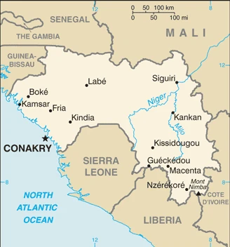
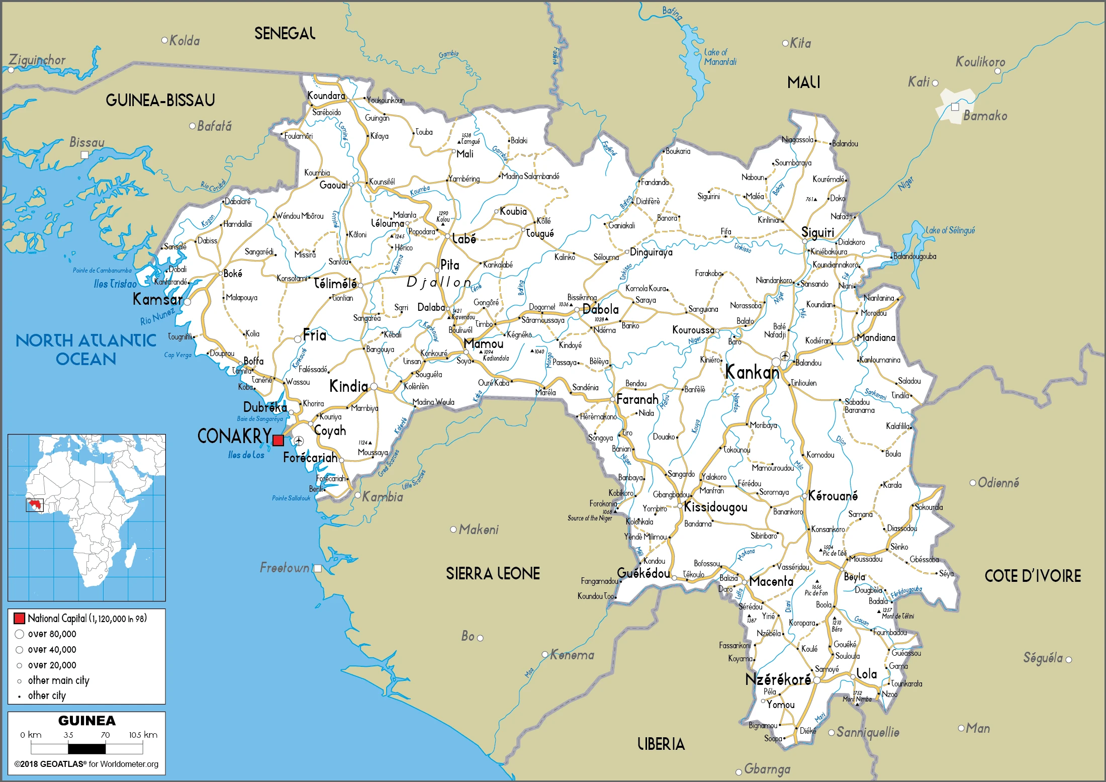
This state is located in Western Africa, bordering the North Atlantic Ocean, between Guinea-Bissau and Sierra Leone, under the coordinates of 11 00 N, 10 00 W, covering an area of 245,857 sq km with a coastline of 320 km. Guinea is Slightly smaller than Oregon, slightly larger than twice the size of Pennsylvania.
Guinea has 4,046 km of land boundaries in total and borders with (6 nations): Côte d’Ivoire 816 km, Guinea-Bissau 421 km, Liberia 590 km, Mali 1062 km, Senegal 363 km, Sierra Leone 794 km.
The generally flat coastal plain, hilly to the mountainous interior, with Mont Nimba 1,752 m as the highest point of Guinea, while Atlantic Ocean 0 m as the lowest point, causing a mean elevation at 472 m throughout the country. With a total of 245,857 sq km, Guinea has 245,717 sq km of land and 140 sq km water surface area.
The principal rivers are the Niger river source (shared with Mali and Nigeria) – 4,200 km, the Gambia river source (shared with Senegal and The Gambia) – 1,094 km. The significant watersheds for Guinea are Atlantic Ocean drainage: Niger (2,261,741 sq km) Senegal (456,397 sq km).
The Niger and its important tributary, the Milo River, are sourced in the Guinean highlands.
The climate in Guinea is as follows: Generally hot and humid, monsoonal-type rainy season (June to November) with southwesterly winds, dry season (December to May) with northeasterly harmattan winds.
When you visit Guinea, the natural hazards shall be considered: Hot, dry, dusty harmattan haze may reduce visibility during the dry season.
The following major health-threatening issues shall be considered when visiting Guinea: degree of risk: very high (2020), bacterial and protozoal diarrhea, hepatitis A, typhoid fever, malaria, dengue fever, yellow fever, schistosomiasis, rabies, Lassa fever.
Current environmental issues affecting the Guinean people: deforestation; inadequate potable water; desertification; soil contamination and erosion; overfishing, overpopulation in forest regions; poor mining practices leading to environmental damage; water pollution; improper waste disposal.
Google Maps Guinea
The capital and other divisions
Capital city: Conakry found under the coordinates 9 30 N, 13 42 W, applying the time zone UTC 0 (5 hours ahead of Washington, DC, during Standard Time), using the following daylight saving time: none.
Conakry is the capital of Guinea. Sierra Leone borders it to the west, Ivory Coast and Liberia to the south, and Mali to the east. Conakry is a large city with an estimated population of 2 million as of 2014.
Guinea became independent on 2 October 1958 (from France), and its national holiday is Independence Day, 2 October (1958).
Administrative divisions: 7 regions administrative and 1 gouvenorat; Boke, Conakry, Faranah, Kankan, Kindia, Labe, Mamou, NZerekore.
People and society
Peul and Malinké make up most of the population, but rivalries between them have allowed coastal peoples such as the Soussou to dominate politics. Daily life revolves around the extended family. Women acquired influence under Marxist party rule between 1958 and 1984, but the Muslim revival has reversed the trend since then. Private enterprise has created a business class. A deadly Ebola outbreak hit the country in 2014.
The population in Guinea is 12,877,894 (July 2021 estimate), with an average of 2.76% (2021 estimate) change. That means Guinea is the No. 76 in the world’s populated rank list. With an average of 19.1 years median age (18.9 years for males and 18.9 years for women), Guinea ranks No. 205 on the globe’s median age rank list.
The people living in this country are the Guinean(s) (noun) or Guinean (adjective) and belong mainly to the following ethnic groups: Fulani (Peuhl) 33.4%, Malinke 29.4%, Susu 21.2%, Guerze 7.8%, Kissi 6.2%, Toma 1.6%, other/foreign 0.4% (2018 estimate).
They speak French (official language), Pular, Maninka, Susu, other native languages. Note: about 40 languages are spoken; each ethnic group has its language languages and practice the following religions: Muslim 89.1%, Christian 6.8%, animist 1.6%, other 0.1%, none 2.4% (2014 estimate).
We can conclude the following about the population in Guinea: Areas of highest density area in the west and south. The interior is sparsely populated, as shown in this population distribution map. In Guinea, we are talking about 37.3% (2021) of the total population is living in cities, and most of them reside in the following municipalities: 1.991 million, Conakry (capital city) (2021).
Industry
Substantial gold, diamond, and especially bauxite reserves. Cash crops: bananas, coffee, pineapples, palm oil. Poor infrastructure. Instability.
Guinea is a developing country with approximately 12.9 million people in 2016 that possesses the world’s largest reserves of bauxite and largest untapped high-grade iron ore reserves and gold and diamonds. In addition, Guinea has fertile soil with ample rainfall and is the source of several West African rivers, including Senegal, Niger, and The Gambia. Guinea’s hydro potential is enormous, and the country could be a significant exporter of electricity. The country also has tremendous agricultural potential. Gold, bauxite, and diamonds are Guinea’s main exports. International investors have shown interest in Guineas unexplored mineral reserves, which have the potential to propel Guineas future growth., Following the death of long-term President Lansana CONTE in 2008 and the coup that followed, international donors, including the G-8, the IMF, and the World Bank, significantly curtailed their development programs in Guinea. However, the IMF approved a 3-year Extended Credit Facility arrangement in 2012, following the December 2010 presidential elections. In September 2012, Guinea achieved Heavily Indebted Poor Countries completion point status. Future access to international assistance and investment will depend on the government’s ability to be transparent, combat corruption, reform its banking system, improve its business environment, and build infrastructure.
In April 2013, the government amended its mining code to reduce taxes and royalties. In 2014, Guinea complied with the requirements of the Extractive Industries Transparency Initiative by publishing its mining contracts. Guinea completed its program with the IMF in October 2016, even though some targeted reforms have been delayed. Currently, Guinea is negotiating a new IMF program based on Guinea’s new five-year economic plan, focusing on developing higher value-added products, including from the agro-business sector and the development of the rural economy. Political instability, a reintroduction of the Ebola virus epidemic, low international commodity prices, and an enduring legacy of corruption, inefficiency, and lack of government transparency are factors that could impact Guinea’s future growth. Economic recovery will be a long process while the government adjusts to lower inflows of international donor aid following the surge of Ebola-related emergency support. Ebola stalled promising economic growth in the 2014-15 period and impeded several projects, such as offshore oil exploration and the Simandou iron ore project. However, the economy grew by 6.6% in 2016 and 6.7% in 2017, mainly due to growth from bauxite mining and thermal energy generation and the resiliency of the agricultural sector.
The 240-megawatt Kaleta Dam, inaugurated in September 2015, has expanded access to electricity for residents of Conakry. Combined with fears of the Ebola virus, it undermines Guinea’s economic viability. The Guineas iron ore industry took a hit in 2016 when investors in the Simandou iron ore project announced plans to divest. In 2017, agriculture output and public investment boosted economic growth, while the mining sector continued to play a prominent role in economic performance. Successive governments have failed to address the country’s crumbling infrastructure. Guinea suffers from chronic electricity shortages, poor roads, rail lines, bridges, and a lack of access to clean water – all of which continue to plague economic development. The present government, led by President Alpha CONDE, is working to create an environment to attract foreign investment and hopes to have greater participation from western countries and firms in Guineas economic development.
Guinea is rich in the following natural resources: Bauxite, iron ore, diamonds, gold, uranium, hydropower, fish, salt.
The main industrial sectors are typically bauxite, gold, diamonds, iron ore, light manufacturing, agricultural processing.
The country’s export sectors are particularly strong in aluminum, gold, bauxite, diamonds, fish, cashews (2019), partnering with these nations: the United Arab Emirates 39%, China 36%, India 6% (2019). The export trade resulted in $4.04 billion. Note: Data are in current year dollars (2019 estimate). In a global rank of the export, values resulted in Guinea’s position of 135.
Land use in Guinea: 26.5% (2018 estimate) forest, 15.4% (2018 estimate) other.
The arable land area is 11.8% (2018 estimate), and the agricultural land is 58.1% (2018 estimate). Land use for permanent crops 2.8% (2018 estimate), permanent pasture 43.5% (2018 estimate). The sum of the area of the irrigated land is 950 sq km (2012).
The main agro-industrial products of Guinea are rice, cassava, groundnuts, maize, oil palm fruit, fonio, plantains, sugar cane, sweet potatoes, vegetables.
The country typically needs to import: rice, refined petroleum, packaged medicines, delivery trucks, cars (2019), partnering with the following nations: China 39%, India 8%, Netherlands 6%, Belgium 5%, United Arab Emirates 5% (2019) in a sum value of $4.32 billion. Note: data are in current year dollars (2019 estimate) $4.18 billion. Note: data are in current year dollars (2018 estimate) $7.317 billion (2017 estimate). This sum value on the global ranking list of imports resulted in Guinea 146.
Guinea Driving Directions
In this post, you learned about Guinea, Western Africa, bordering the North Atlantic Ocean, between Guinea-Bissau and Sierra Leone. We published some basic information about its capital Conakry, and the Guinean nation.
Are you interested in visiting Guinea and looking for driving directions? Click here to plan your route, or see a printable road map of Guinea below for an overview of the route network.
Printable map of Guinea
Did you know about Guinea?
Guinea is a country in West Africa named after the Guinea River. Senegal borders it in the north, Mali to the northeast, and Niger to the east and south. The capital city is Conakry. There are over 25 ethnic groups living in Guinea, but about 90% of people are part of the Malinke group. The history of Guinea is rich with stories of explorers, rulers, traders, and other visitors from Europe.
After virtually visiting Guinea, you may also be interested in the neighboring countries: Côte d’Ivoire, Guinea-Bissau, Liberia, Mali, Senegal, Sierra Leone.
If you liked our Google map and Guinea information page,
please share it with others or save the link https://www.drivingdirections.net in your bookmarks.