
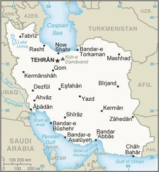
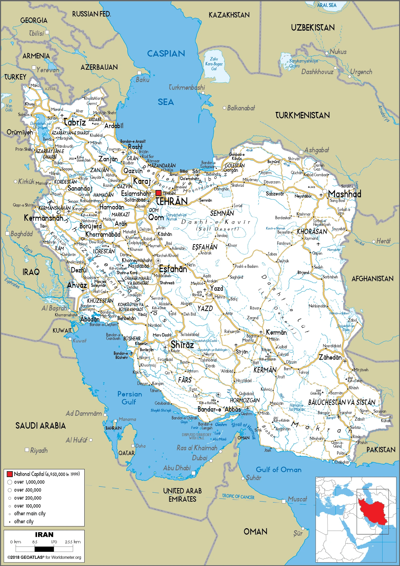
Iran Google Maps is a site/tool that offers a wide range of map views (topographic, satellite, street view) and navigation options, with little effort on your part, yet efficiently. If you need to plan a trip to a new place like Iran, Google maps are available on desktop, mobile, or tablet. This Google maps and information page is dedicated to Iran, Middle East (19 countries), showing its location, country facts, details about its capital city Tehran, bordering countries like Afghanistan, Armenia, Azerbaijan, Iraq, Pakistan, Turkey, Turkmenistan, and plenty of other information which may be interesting when you visit this Middle Eastern state.
Quick links: Google Maps Iran, Tehran Google maps, Driving Directions Iran, Printable Road Map.
About Iran in a nutshell
- More than a hundred offenses carry the death penalty.
- Conventional short form of the name: Iran
- The conventional long form of the name: Islamic Republic of Iran
- Local long form: Jomhuri-ye Eslami-ye Iran
- Local short form: Iran
- Former name(s): Persia
- Etymology: name derives from the Avestan term aryanam meaning Land of the Noble Ones.
- The legal system in Iran: religious legal system based on secular and Islamic law.
- Climate: Desert climate. Hot summers, and bitterly cold winters. Area around the Caspian Sea is more temperate.
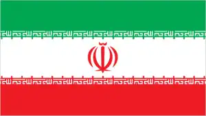
- The national symbols are lion; national colors: green, white, red.
- Internet TLD: .ir
Background
Known as Persia until 1935, Iran became an Islamic republic in 1979 after the ruling monarchy was overthrown and Shah Mohammad Reza PAHLAVI was forced into exile. Conservative clerical forces led by Ayatollah Ruhollah KHOMEINI established a theocratic system of government with the ultimate political authority vested in a learned religious scholar referred to commonly as the Supreme Leader who, according to the constitution, is accountable only to the Assembly of Experts (AOE) – a popularly elected 88-member body of clerics. US-Iranian relations became strained when Iranian students seized the US Embassy in Tehran in November 1979 and held embassy personnel hostages until mid-January 1981. The US cut off diplomatic relations with Iran in April 1980.
During 1980-1988, Iran fought a bloody, indecisive war with Iraq that eventually expanded into the Persian Gulf and led to clashes between US Navy and Iranian military forces. Iran has been designated a state sponsor of terrorism and was subject to US, UN, and EU economic sanctions and export controls because of its continued involvement in terrorism and concerns over possible military dimensions of its nuclear program until the Joint Comprehensive Plan of Action (JCPOA) Implementation Day in 2016. The US began re-imposing sanctions gradually on Iran after the US withdrawal from JCPOA in May 2018. Following the election of reformer Hojjat ol-Eslam Mohammad KHATAMI as president in 1997 and a reformist Majles (legislature) in 2000, a campaign to foster political reform in response to popular dissatisfaction was initiated. The movement floundered as conservative politicians, supported by the Supreme Leader, unelected institutions of authority like the Council of Guardians. The security services reversed and blocked reform measures while increasing security repression. Starting with nationwide municipal elections in 2003 and continuing through Majles elections in 2004, conservatives reestablished control over Iran’s elected government institutions, culminating with the August 2005 inauguration of hardliner Mahmud AHMADI-NEJAD as president. His controversial reelection in June 2009 sparked nationwide protests over allegations of electoral fraud, but the protests were quickly suppressed.
Deteriorating economic conditions due primarily to government mismanagement and international sanctions prompted two major economically based protests in July and October 2012, but Iran’s internal security situation remained stable. President AHMADI-NEJADs independent streak angered regime establishment figures, including the Supreme Leader, leading to conservative opposition to his agenda for the last year of his presidency and an alienation of his political supporters. In June 2013, Iranians elected a centrist cleric Dr. Hasan Fereidun ROHANI, to the presidency. He is a long-time senior member of the regime but has promised to reform society and Iran’s foreign policy. The UN Security Council has passed several resolutions calling for Iran to suspend its uranium enrichment and reprocessing activities and comply with its IAEA obligations and responsibilities. In July 2015, Iran and the five permanent members, plus Germany (P5+1), signed the JCPOA under which Iran agreed to restrictions on its nuclear program in exchange for sanctions relief. Iran held elections in 2016 for the AOE and Majles, resulting in a conservative-controlled AOE and a Majles that many Iranians perceive as more supportive of the ROHANI administration than the previous, conservative-dominated body. ROHANI was reelected president in May 2017. Economic concerns again led to nationwide protests in December 2017 and January 2018, but Irans security services contained them. Additional widespread economic protests broke out in November 2019 in response to the raised price of subsidized gasoline.
Geography
High desert plateau with large salt pans in the east. West and north are mountainous. Coastal land bordering the Caspian Sea is rainy and forested.
Since the 1979 Islamic fundamentalist revolution led by Ayatollah Khomeini, the Middle Eastern country of Iran has been the worlds largest theocracy.
This state is located in the Middle East, bordering the Gulf of Oman, the Persian Gulf, and the Caspian Sea, between Iraq and Pakistan, under the coordinates of 32 00 N, 53 00 E, covering an area of 1,648,195 sq km with a coastline of 2,440 km. Iran is Almost 2.5 times the size of Texas, slightly smaller than Alaska.
Iran has 5,894 km of land boundaries in total, and bordering with (7 nations): Afghanistan 921 km, Armenia 44 km, Azerbaijan 689 km, Iraq 1599 km, Pakistan 959 km, Turkey 534 km, Turkmenistan 1148 km.
Rugged, mountainous rim, high, central basin with deserts, mountains, small, discontinuous plains along both coasts, with Kuh-e Damavand 5,625 m as the highest point of Iran, while the Caspian Sea -28 m as the lowest point, causing a mean elevation at 1,305 m throughout the country. With a total of 1,648,195 sq km, Iran has 1,531,595 sq km of land and 116,600 sq km water surface area.
Major water bodies in the country: N/A (freshwater lake), Caspian Sea (shared with Russia, Azerbaijan, Turkmenistan, and Kazakhstan) – 374,000 sq km; Lake Urmia – 5,200 sq km; Lake Namak – 750 sq km (saltwater lake) while the major rivers are: Euphrates (shared with Turkey, Syria, and Iraq m) – 3,596 km, Tigris (shared with Turkey, Syria, and Iraq) – 1,950 km, Helmand (shared with Afghanistan) – 1,130 km. The significant watersheds for Iran are the Indian Ocean drainage: (Persian Gulf), Tigris, and Euphrates (918,044 sq km).
Strategic location on the Persian Gulf and Strait of Hormuz, which are vital maritime pathways for crude oil transport.
The climate in Iran is mostly arid or semiarid, subtropical along the Caspian coast.
When you visit Iran, the natural hazards shall be considered: Periodic droughts, floods, dust storms, sandstorms, earthquakes.
The following major health-threatening issues shall be considered when visiting Iran: degree of risk: intermediate (2020), bacterial diarrhea, Crimean-Congo hemorrhagic fever.
Current environmental issues affecting the Iranian people: air pollution, especially in urban areas, from vehicle emissions, refinery operations, and industrial effluents; deforestation; overgrazing; desertification; oil pollution in the Persian Gulf; wetland losses from drought; soil degradation (salination); inadequate supplies of potable water; water pollution from raw sewage and industrial waste; urbanization.
Google Maps Iran
The capital and other divisions
Capital city: Tehran found under the coordinates 35 42 N, 51 25 E, applying the time zone UTC+3.5 (8.5 hours ahead of Washington, DC, during Standard Time), using the following daylight saving time: +1hr, begins fourth Wednesday in March; ends fourth Friday in September.
Tehran is Iran’s largest city and capital, with a high population of 3.2 million people. For many years now, Tehran has also been home to many foreign embassies and Iranian embassies abroad. A major tourist destination for its old architecture and plethora of cultural attractions, you will find many things to do in Tehran. If you’re visiting Iran, be sure to make it a priority to see this captivating city.
Iran became independent on 1 April 1979 (the Islamic Republic of Iran proclaimed); notable earlier dates: ca. 550 B.C. (Achaemenid (Persian) Empire established); A.D. 1501 (Iran reunified under the Safavid Dynasty); 1794 (beginning of Qajar Dynasty); 12 December 1925 (modern Iran established under the PAHLAVI Dynasty), and its national holiday is Republic Day, 1 April (1979).
Administrative divisions: 31 provinces (ostanha, singular – ostan); Alborz, Ardabil, Azarbayjan-e Gharbi (West Azerbaijan), Azarbayjan-e Sharqi (East Azerbaijan), Bushehr, Chahar Mahal va Bakhtiari, Esfahan, Fars, Gilan, Golestan, Hamadan, Hormozgan, Ilam, Kerman, Kermanshah, Khorasan-e Jonubi (South Khorasan), Khorasan-e Razavi (Razavi Khorasan), Khorasan-e Shomali (North Khorasan), Khuzestan, Kohgiluyeh va Bowyer Ahmad, Kordestan, Lorestan, Markazi, Mazandaran, Qazvin, Qom, Semnan, Sistan va Baluchestan, Tehran, Yazd, Zanjan.
People and society
Many ethnic groups, including Persians, Azaris (ethnically related to Azeris), and Kurds. Militant Shia Islamism has dominated since the 1979 revolution. The mullah’s belief that adherence to religious values is more important than economic welfare has led to falling living standards. Female emancipation has been reversed. Student-backed demonstrations favoring greater liberalism have been suppressed. International sanctions press for the end of the uranium enrichment program.
The population in Iran is 85,888,910 (July 2021 estimate), with an average of 1.03% (2021 estimate) change. That means Iran is the No. 17 in the world’s populated rank list. With an average of 31.7 years median age (31.5 years for males and 31.5 years for women), Iran ranks No. 113 on the globe’s median age rank list.
The people living in this country are the Iranian(s) (noun) or Iranian (adjective) and belong mainly to the following ethnic groups: Persian, Azeri, Kurd, Lur, Baloch, Arab, Turkmen, and Turkic tribes.
They speak Persian Farsi (official language), Azeri and other Turkic dialects, Kurdish, Gilaki and Mazandarani, Luri, Balochi, Arabic languages and practice the following religions: Muslim (official) 99.4% (Shia 90-95%, Sunni 5-10%), other (includes Zoroastrian, Jewish, and Christian) 0.3%, unspecified 0.4% (2011 estimate).
We can conclude the following about the population in Iran: Population is concentrated in the north, northwest, and west, reflecting the position of the Zagros and Elburz mountains. The vast dry areas in the center and eastern parts of the country, around the deserts of the Dasht-e Kavir and the Dasht-e Lut, have a much lower population density. In Iran, we are talking about 76.3% (2021) of the total population is living in cities. Most of them reside in the following municipalities: 9.259 million, Tehran (capital city), 3.264 million, Mashhad, 2.177 million, Esfahan, 1.675 million, Shiraz, 1.627 million, Tabriz, 1.582 million, Karaj (2021).
Industry
A leading oil producer, though sanctions limit exports. The government restricts contact with the West, blocking the acquisition of vital technology. High unemployment, inflation. Black market.
Iran’s economy is marked by statist policies, inefficiencies, and reliance on oil and gas exports, but Iran also possesses significant agricultural, industrial, and service sectors. The Iranian government directly owns and operates hundreds of state-owned enterprises and indirectly controls many companies affiliated with the country’s security forces. Distortions – including corruption, price controls, subsidies, and a banking system holding billions of dollars of non-performing loans – weigh down the economy, undermining the potential for private-sector-led growth., Private sector activity includes small-scale workshops, farming, some manufacturing, and services, in addition to medium-scale construction, cement production, mining, and metalworking.
Significant informal market activity flourishes, and corruption is widespread. The lifting of most nuclear-related sanctions under the Joint Comprehensive Plan of Action (JCPOA) in January 2016 sparked a restoration of Iran’s oil production and revenue that drove rapid GDP growth. Still, economic growth declined in 2017 as oil production plateaued. The economy continues to suffer from low levels of investment and declines in productivity since before the JCPOA, and high levels of unemployment, especially among women and college-educated Iranian youth. In May 2017, the re-election of President Hasan RUHANI generated widespread public expectations that the economic benefits of the JCPOA would expand and reach all levels of society. RUHANI will need to implement structural reforms that strengthen the banking sector and improve Iran’s business climate to attract foreign investment and encourage the growth of the private sector. Sanctions unrelated to Iran’s nuclear program remain in effect, and theseplus fears over the possible re-imposition of nuclear-related sanctionswill continue to deter foreign investors from engaging with Iran.
Iran is rich in the following natural resources: Petroleum, natural gas, coal, chromium, copper, iron ore, lead, manganese, zinc, sulfur.
The main industrial sectors are typically petroleum, petrochemicals, gas, fertilizer, caustic soda, textiles, cement, other construction materials, food processing (particularly sugar refining and vegetable oil production), ferrous and nonferrous metal fabrication, armaments.
The country’s export sectors are particularly strong in crude petroleum, polymers, industrial alcohols, iron, pistachios (2019), partnering with these nations: China 48%, India 12%, South Korea 8%, Turkey 6%, the United Arab Emirates 5% (2019). The export trade resulted in $101.4 billion. Note: Data are in current year dollars (2017 estimate). In a global rank of the export, values resulted in Iran’s position of 40.
Land use in Iran: 6.8% (2018 estimate) forest, 63.1% (2018 estimate) other.
The arable land area is 10.8% (2018 estimate), and the agricultural land is 30.1% (2018 estimate). Land use for permanent crops 1.2% (2018 estimate), permanent pasture 18.1% (2018 estimate). The sum of the area of the irrigated land is 95,530 sq km (2012).
The main agro-industrial products of Iran are wheat, sugar cane, milk, sugar beet, tomatoes, barley, potatoes, oranges, poultry, apples.
The country typically needs to import: rice, corn, broadcasting equipment, soybean products, beef (2019), partnering with the following nations: China 28%, United Arab Emirates 20%, India 11%, Turkey 7%, Brazil 6%, Germany 5% (2019) in a sum value of $76.39 billion (2017 estimate) $63.14 billion (2016 estimate). This sum value on the global ranking list of imports resulted in Iran 46.
Iran Driving Directions
In this post, you learned about Iran, the Middle East, bordering the Gulf of Oman, the Persian Gulf, and the Caspian Sea, between Iraq and Pakistan. We published some basic information about its capital Tehran, and the Iranian nation.
Are you interested in visiting Iran and looking for driving directions? Click here to plan your route, or see a printable road map of Iran below for an overview of the route network.
Printable map of Iran
Did you know about Iran?
If you have not been paying attention to the news, Iran is becoming a bit more and more of a controversial issue. There are many different perspectives from both sides of the aisle on whether Iran should be allowed to continue their nuclear development. The United States has placed sanctions on certain individuals in Iran, so politicians must understand that this country cannot be trusted.
After virtually visiting Iran, you may also be interested in the neighboring countries: Afghanistan, Armenia, Azerbaijan, Iraq, Pakistan, Turkey, Turkmenistan.
If you liked our Google map and Iran information page,
please share it with others or save the link https://www.drivingdirections.net in your bookmarks.