
Kyrgyzstan Google Maps is a site/tool that offers a wide range of map views (topographic, satellite, street view) and navigation options, with little effort on your part, yet efficiently. If you need to plan a trip to a new place like Kyrgyzstan, Google maps are available on desktop, mobile, or tablet. This Google maps and information page is dedicated to Kyrgyzstan, Asia (22 countries), showing its location, country facts, details about its capital city Bishkek, bordering countries like China, Kazakhstan, Tajikistan, Uzbekistan, and plenty of other information which may be interesting when you visit this Asian state.
Quick links: Google Maps Kyrgyzstan, Bishkek Google maps, Driving Directions Kyrgyzstan, Printable Road Map.
About Kyrgyzstan in a nutshell
- Kyrgyz folklore is based around the 1000-year-old poem, Manas, which takes a week to recite.
- Conventional short form of the name: Kyrgyzstan
- The conventional long form of the name: Kyrgyz Republic
- Local long form: Kyrgyz Respublikasy
- Local short form: Kyrgyzstan
- Former name(s): Kirghiz Soviet Socialist Republic
- Etymology: a combination of the Turkic words kyrg (forty) and -yz (tribes) with the Persian suffix -stan (country) creating the meaning Land of the Forty Tribes; the name refers to the 40 clans united by the legendary Kyrgyz hero, MANAS.
- The legal system in Kyrgyzstan: civil law system, which includes features of French civil law and Russian Federation laws.
- Climate: Varies from permanent snow and cold deserts at high altitudes, to hot deserts in low regions.
- The national symbols are white falcon; national colors: red, yellow.
- Internet TLD: .kg
Nestled between the central Tien-san ranges, the former Soviet republic is the most popular and accessible Central Asian destination because of its unspoiled nature. Its infrastructure is still underdeveloped, but its hospitable Muslim inhabitants, who respect nomadic traditions, welcome fermented mare’s milk visitors. The capital’s name is also linked to mare’s milk fermentation tradition: Biskek means wooden spit. The country’s most popular tourist attractions are the Ala-Arcsa Gorge near the capital and the world’s second-largest alpine lake, Iszik-Köl, at 1,600 m.
Background
A Central Asian country of incredible natural beauty and proud nomadic traditions, most of the territory of the present-day Kyrgyz Republic was formally annexed to the Russian Empire in 1876. The Kyrgyz staged a major revolt against the Tsarist Empire in 1916, in which almost one-sixth of the Kyrgyz population was killed. The Kyrgyz Republic became a Soviet republic in 1936 and achieved independence in 1991 when the USSR dissolved. Nationwide demonstrations in 2005 and 2010 resulted in the ouster of the country’s first two presidents, Askar AKAEV and Kurmanbek BAKIEV. Interim President Roza OTUNBAEVA led a transitional government, and following a nationwide election, President Almazbek ATAMBAEV was sworn in as president in 2011. In 2017, ATAMBAEV became the first Kyrgyzstani president to step down after serving one full six-year term as required in the country’s constitution.
The former prime minister and ruling Social-Democratic Party of Kyrgyzstan member Sooronbay JEENBEKOV replaced him after winning an October 2017 presidential election that was the most competitive in the country’s history. However, international and local election observers noted cases of vote-buying and abuse of public resources. The president holds substantial powers as head of state even though the prime minister oversees the Kyrgyzstani Government and selects most cabinet members. The president represents the country internationally and can sign or veto laws, call for new elections, nominate Supreme Court judges, cabinet members for posts related to security or defense, and numerous other high-level positions. Continuing concerns for the Kyrgyz Republic include the trajectory of democratization, endemic corruption, a history of tense, and at times violent, interethnic relations, border security vulnerabilities, and potential terrorist threats.
Geography
The mountainous spurs of the Tien Shan range contain glaciers, alpine meadows, forests, and narrow valleys. Semidesert in the west.
A small and mountainous landlocked state in central Asia, Kyrgyzstan is one of the least urbanized ex-Soviet republics and was slow to develop its sense of cultural identity.
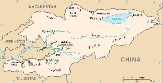
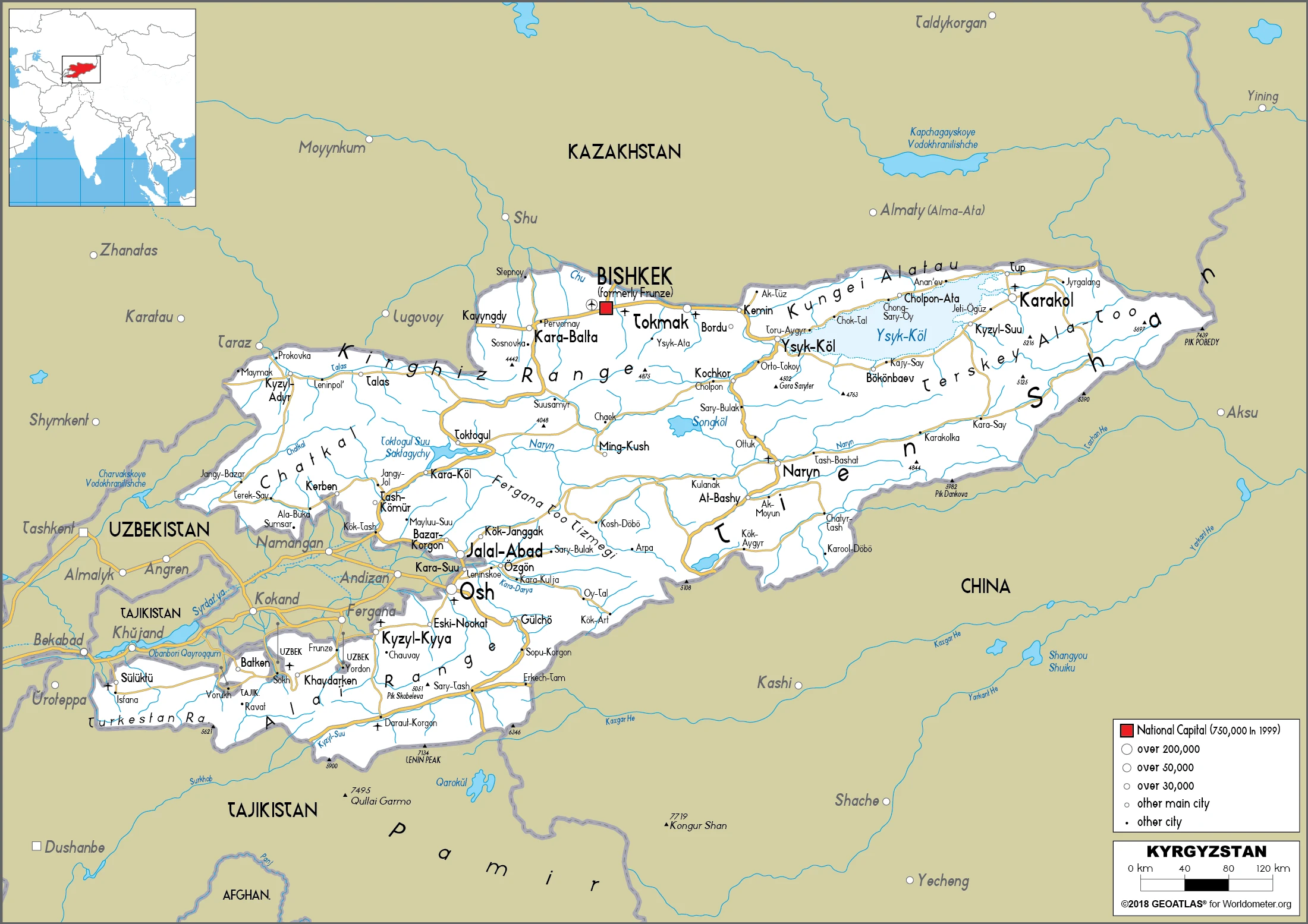
This state is located in Central Asia, west of China, south of Kazakhstan, under the coordinates of 41 00 N, 75 00 E, covering an area of 199,951 sq km with a coastline of 0 km (landlocked country). Kyrgyzstan is Slightly smaller than South Dakota.
Kyrgyzstan has 4,573 km of land boundaries and borders with (4 nations): China 1063 km, Kazakhstan 1212 km, Tajikistan 984 km, Uzbekistan 1314 km.
Peaks of the Tien Shan mountain range and associated valleys and basins encompass the entire country, with Jengish Chokusu (Pik Pobedy) 7,439 m as the highest point of Kyrgyzstan, while Kara-Daryya (Karadarya) 132 m as the lowest point, causing a mean elevation at 2,988 m throughout the country. With a total of 199,951 sq km, Kyrgyzstan has 191,801 sq km of land and 8,150 sq km water surface area.
Major water bodies in the country: Ozero Issyk-Kul 6,240 sq km (saltwater lake) while the major rivers are: Syr Darya (shared with Kazakhstan, Uzbekistan, and Tajikistan) – 3,078 km. The significant watersheds for Kyrgyzstan are Internal (endorheic basin) drainage: Tarim Basin (1,152,448 sq km), (Aral Sea basin), Amu Darya (534,739 sq km), Syr Darya (782,617 sq km).
Landlocked; entirely mountainous, dominated by the Tien Shan range; 94% of the country is 1,000 m above sea level with an average elevation of 2,750 m; many tall peaks, glaciers, and high-altitude lakes.
The climate in Kyrgyzstan is as follows: Dry continental to polar in high Tien Shan mountains, subtropical in southwest (Fergana Valley), temperate in northern foothill zone.
When you visit Kyrgyzstan, the natural hazards are major flooding during snowmelt; prone to earthquakes.
The following major health-threatening issues shall be considered when visiting Kyrgyzstan: none.
Current environmental issues affecting the Kyrgyzstani people: water pollution; many people get their water directly from contaminated streams and wells; as a result, water-borne diseases are prevalent; increasing soil salinity from faulty irrigation practices; air pollution due to the rapid increase of traffic.
Google Maps Kyrgyzstan
The capital and other divisions
Capital city: Bishkek found under the coordinates 42 52 N, 74 36 E, applying the time zone UTC+6 (11 hours ahead of Washington, DC, during Standard Time), using the following daylight saving time: none.
Bishkek is the capital and largest city of Kyrgyzstan. It is located in the north of the country on the northern shore of Issyk Kul Lake. It has been a seat of power since 1832.
Kyrgyzstan became independent on 31 August 1991 (from the Soviet Union), and its national holiday is Independence Day, 31 August (1991).
Administrative divisions: 7 provinces (oblustar, singular – oblus) and 2 cities (shaarlar, singular – shaar); Batken Oblusu, Bishkek Shaary, Chuy Oblusu (Bishkek), Jalal-Abad Oblusu, Naryn Oblusu, Osh Oblusu, Osh Shaary, Talas Oblusu, Ysyk-Kol Oblusu (Karakol) note: administrative divisions have the same names as their administrative centers (exceptions have the administrative center name following in parentheses).
People and society
Ethnic Kyrgyz have only been in the majority since the late 1980s due to a high birth rate and the emigration of ethnic Russians. Wary of losing skills vital to the economy, the government has attempted to deter Russians from leaving; concessions include making Russian an official language. There are tensions between Kyrgyz and Uzbeks and a trend toward greater Islamization, particularly in the poorer south.
The population in Kyrgyzstan is 6,018,789 (July 2021 estimate), with an average of 0.9% (2021 estimate) change. That means Kyrgyzstan is the No. 112 in the world’s populated rank list. With an average of 27.3 years median age (26.1 years for males and 26.1 years for women), Kyrgyzstan ranks No. 147 on the globe’s median age rank list.
The people living in this country are the Kyrgyzstani(s) (noun) or Kyrgyzstani (adjective) and belong mainly to the following ethnic groups: Kyrgyz 73.5%, Uzbek 14.7%, Russian 5.5%, Dungan 1.1%, other 5.2% (includes Uyghur, Tajik, Turk, Kazakh, Tatar, Ukrainian, Korean, German) (2019 estimate).
They speak Kyrgyz (official language) 71.4%, Uzbek 14.4%, Russian (official language) 9%, other 5.2% (2009 estimate) languages and practice the following religions: Muslim 90% (majority Sunni), Christian 7% (Russian Orthodox 3%), other 3% (includes Jewish, Buddhist, Bahai) (2017 estimate).
We can conclude the following about the population in Kyrgyzstan: The vast majority of Kyrgyzstanis live in rural areas. The densest population settlement is to the north in and around the capital, Bishkek, followed by Osh in the west. The least densely populated area in the east and southeast is the Tien Shan mountains. In Kyrgyzstan, we are talking about 37.1% (2021) of the total population is living in cities, and most of them reside in the following municipalities: 1.060 million, Bishkek (capital city) (2021).
Industry
Mainly still under state control; corruption issues. Agriculture employs a third of the labor force. Cotton, wool, meat, and tobacco exports. Mercury, gold, and antimony are mined. Great potential for hydroelectric power.
Kyrgyzstan is a landlocked, mountainous, lower-middle-income country with an economy dominated by minerals extraction, agriculture, and reliance on remittances from citizens working abroad. Cotton, wool, and meat are the primary agricultural products, although only cotton is exported in any quantity. Other exports include gold, mercury, uranium, natural gas, and – in some years – electricity. The country has sought to attract foreign investment to expand its export base, including hydroelectric dams. Still, a challenging investment climate and an ongoing legal battle with a Canadian firm over the nation’s largest gold mine joint ownership structure deter potential investors. Remittances from Kyrgyz migrant workers, predominantly in Russia and Kazakhstan, are equivalent to more than one-quarter of Kyrgyzstan’s GDP. Following independence, Kyrgyzstan rapidly implemented market reforms, such as improving the regulatory system and instituting land reform. In 1998, Kyrgyzstan was the first Commonwealth of Independent States country to be accepted into the World Trade Organization. The government has privatized much of its shares in public enterprises.
Despite these reforms, the country suffered a severe drop in production in the early 1990s and faced slow growth in recent years as the global financial crisis. Declining oil prices have dampened economies across Central Asia. The Kyrgyz government remains dependent on foreign donor support to finance its annual budget deficit of approximately 3 to 5% of GDP. Kyrgyz leaders hope the country’s August 2015 accession to the Eurasian Economic Union (EAEU) will bolster trade and investment. Still, slowing economies in Russia and China and low commodity prices hamper economic growth. Large-scale trade and investment pledged by Kyrgyz leaders have been slow to develop. Many Kyrgyz entrepreneurs and politicians complain that non-tariff measures imposed by other EAEU member states are hurting specific sectors of the Kyrgyz economy, such as meat and dairy production, in which they have a comparative advantage. Since acceding to the EAEU, the Kyrgyz Republic has continued harmonizing its laws and regulations to meet EAEU standards, though many local entrepreneurs believe this process is disjointed and incomplete. Kyrgyzstan’s economic development continues to be hampered by corruption, lack of administrative transparency, lack of diversity in domestic industries, and difficulty attracting foreign aid and investment.
Kyrgyzstan is rich in the following natural resources: Abundant hydropower, gold, rare earth metals, locally exploitable coal, oil, natural gas, other deposits of nepheline, mercury, bismuth, lead, and zinc.
The main industrial sectors are typically small machinery, textiles, food processing, cement, shoes, lumber, refrigerators, furniture, electric motors, gold, rare earth metals.
The country’s export sectors are influential in gold, precious metals, various beans, refined petroleum, scrap copper (2019), partnering with these nations: the United Kingdom 56%, Kazakhstan 13%, Russia 13%, Uzbekistan 5% (2019). The export trade resulted in $3.11 billion. Note: Data are in current year dollars (2019 estimate). In a global rank of the export, values resulted in Kyrgyzstan’s position of 144.
Land use in Kyrgyzstan: 5.1% (2018 estimate) forest, 39.5% (2018 estimate) other.
The arable land area is 6.7% (2018 estimate), and the agricultural land is 55.4% (2018 estimate). Land use for permanent crops 0.4% (2018 estimate), permanent pasture 48.3% (2018 estimate). The sum of the area of the irrigated land is 10,233 sq km (2012).
The main agro-industrial products of Kyrgyzstan are milk, potatoes, sugar beet, maize, wheat, barley, tomatoes, watermelons, onions, carrots/turnips.
The country typically needs to import: refined petroleum, footwear, clothing and apparel, broadcasting equipment, walnuts (2019), partnering with the following nations: China 53%, Russia 17%, Kazakhstan 7%, Uzbekistan 7%, Turkey 5% (2019) in a sum value of $5.67 billion. Note: data are in current year dollars (2019 estimate) $5.86 billion. Note: data are in current year dollars (2018 estimate) $4.953 billion (2017 estimate). This sum value on the global ranking list of imports resulted in Kyrgyzstan 135.
Kyrgyzstan Driving Directions
You learned about Kyrgyzstan, Central Asia, west of China, south of Kazakhstan in this post. We published some basic information about its capital Bishkek, and the Kyrgyzstani nation.
Are you interested in visiting Kyrgyzstan and looking for driving directions? Click here to plan your route, or see a printable road map of Kyrgyzstan below for an overview of the route network.
Printable map of Kyrgyzstan
Did you know about Kyrgyzstan?
Kyrgyzstan, landlocked and mountainous, is a country in Central Asia. Its capital is Bishkek. The country has been called “the Switzerland of Central Asia” because it has a similar landscape to Switzerland and is extremely rich in natural resources.
Russia annexed Kyrgyzstan in 1876, but the locals soon revolted against Russian rule. During this revolt, Kyrgyzs engaged in bloody battles with Russians and each other. In 1916, the country declared independence from Russia after the Bolshevik Revolution toppled Tsar Nicholas II.
After virtually visiting Kyrgyzstan, you may also be interested in the neighboring countries: China, Kazakhstan, Tajikistan, Uzbekistan.
If you liked our Google map and Kyrgyzstan information page,
please share it with others or save the link https://www.drivingdirections.net in your bookmarks.