
Mauritania Google Maps is a site/tool that offers a wide range of map views (topographic, satellite, street view) and navigation options, with little effort on your part, yet efficiently. If you need to plan a trip to a new place like Mauritania, Google maps are available on desktop, mobile, or tablet. This Google maps and information page is dedicated to Mauritania, Africa (54 countries), showing its location, country facts, details about its capital city Nouakchott, bordering countries like Algeria, Mali, Morocco, Senegal, and plenty of other information which may be interesting when you visit this African state.
Quick links: Google Maps Mauritania, Nouakchott Google maps, Driving Directions Mauritania, Printable Road Map.
About Mauritania in a nutshell
- Conventional short form of the name: Mauritania
- The conventional long form of the name: Islamic Republic of Mauritania
- Local long form: Al Jumhuriyah al Islamiyah al Muritaniyah
- Local short form: Muritaniyah
- Former name(s): N/A
- Etymology: named for the ancient kingdom of Mauretania (3rd century B.C. to 1st century A.D.) and the subsequent Roman province (1st-7th centuries A.D.), which existed further north in present-day Morocco; the name derives from the Mauri (Moors), the Berber-speaking peoples of northwest Africa.
- The legal system in Mauritania: mixed legal system of Islamic and French civil law.
- Climate: The is generally hot and dry, aggravated by the dusty harmattan wind. Summer rain in the south, virtually none in the north.
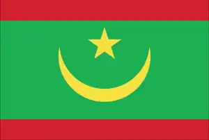
- The national symbols are five-pointed star between the horns of a horizontal crescent moon; national colors: green, yellow.
- Internet TLD: .mr
Mauritania’s borders, drawn along the former French colonial line, are “irregular” to the south by the curve of the Senegal River and the 700 km of Atlantic coastline. The shallow coastal sandbars, the surrounding coastal marshes, and the dunes have created a unique coastal wetland habitat: the Arguin Sandbar National Park is the largest breeding site for migratory birds in West Africa and its habitat for sea turtles and dolphins – a UNESCO World Heritage Site. The cultural world heritage sites of Ouadane, Chinguetti, Tichit, and Oulata, built along the caravan routes between the 11th and 16th centuries, are now sand-buried fortress cities of Mauritania, essentially turned into ‘ghost towns’ – the Ksars – remnants of the nomadic Islamic culture of the peoples of Western Sahara. Chinguetti is the holy city of Islam, with a library of 1,300 13th century volumes. Thanks to the influence of the Azorean Current, Cape Verde is the ‘coolest’ state in West Africa – with temperatures ranging from 20-29°C. When the first Portuguese sailors first landed on the islands, 600 km off the coast of Africa in 1456, the volcanic archipelago of ten large and five small islands was still uninhabited. At the dawn of the new era, the islands played a vital role in the division of the world: in 1494, the Treaty of Tordesillas drew the boundary between the Spanish and Portuguese spheres of interest along the southern circle 370 leagues (about 2,000 kilometers) west of the Cape Verde Islands.
Slavery officially became illegal in Mauritania in 1980, but de facto slavery persists.
Background
The Berber and Bafour people were among the first to settle in what is now Mauritania. Originally a nomadic people, they were among the first recorded history to convert from a nomadic to an agricultural lifestyle. These groups account for roughly one-third of Mauritania’s ethnic makeup. The remainder of Mauritania’s ethnic groups derives from formerly enslaved peoples and sub-Saharan ethnic groups originating mainly from the Senegal River Valley. These three groups constitute a strict caste system with deep ethnic divides that still exist today. Formerly a French colony, Mauritania became an independent state in 1960. Mauritania initially began as a single-party authoritarian regime and saw 49 years of dictatorships, flawed elections, failed attempts at democracy, and military coups. Following the last coup in 2008, Ould Abdel AZIZ was elected president in 2009 and reelected in 2014. International observers recognized the elections as free and fair. AZIZ became the first Mauritanian president to step down and observe a democratic transfer of power following his two terms. This solidified Mauritania’s status as an emerging democracy. After winning 52% of the vote, Mohamed Cheikh El GHAZOUANI was inaugurated in 2019. The country faces several issues, including ethnic tensions and a terrorist threat. Between 2005 and 2011, Al-Qaeda in the Islamic Maghreb (AQIM) launched a series of attacks killing American and foreign tourists and aid workers, attacking diplomatic and government facilities, and ambushing Mauritanian soldiers and gendarmes. Although Mauritania has not seen an attack since 2011, AQIM and similar groups remain active in the Sahel region and threaten Mauritanians and foreign visitors.
Geography
The Sahara, barren except for some scattered oases, covers the north. Savanna lands lie to the south.
Two-thirds of Mauritanias territory is desert the only productive land is drained by the Senegal River. The country has taken a strongly Arab direction since 1964.
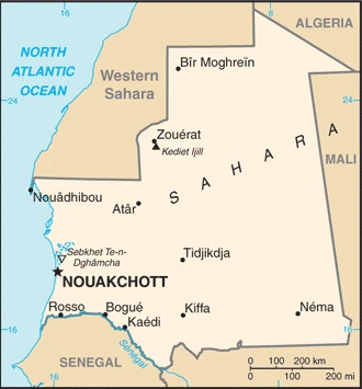
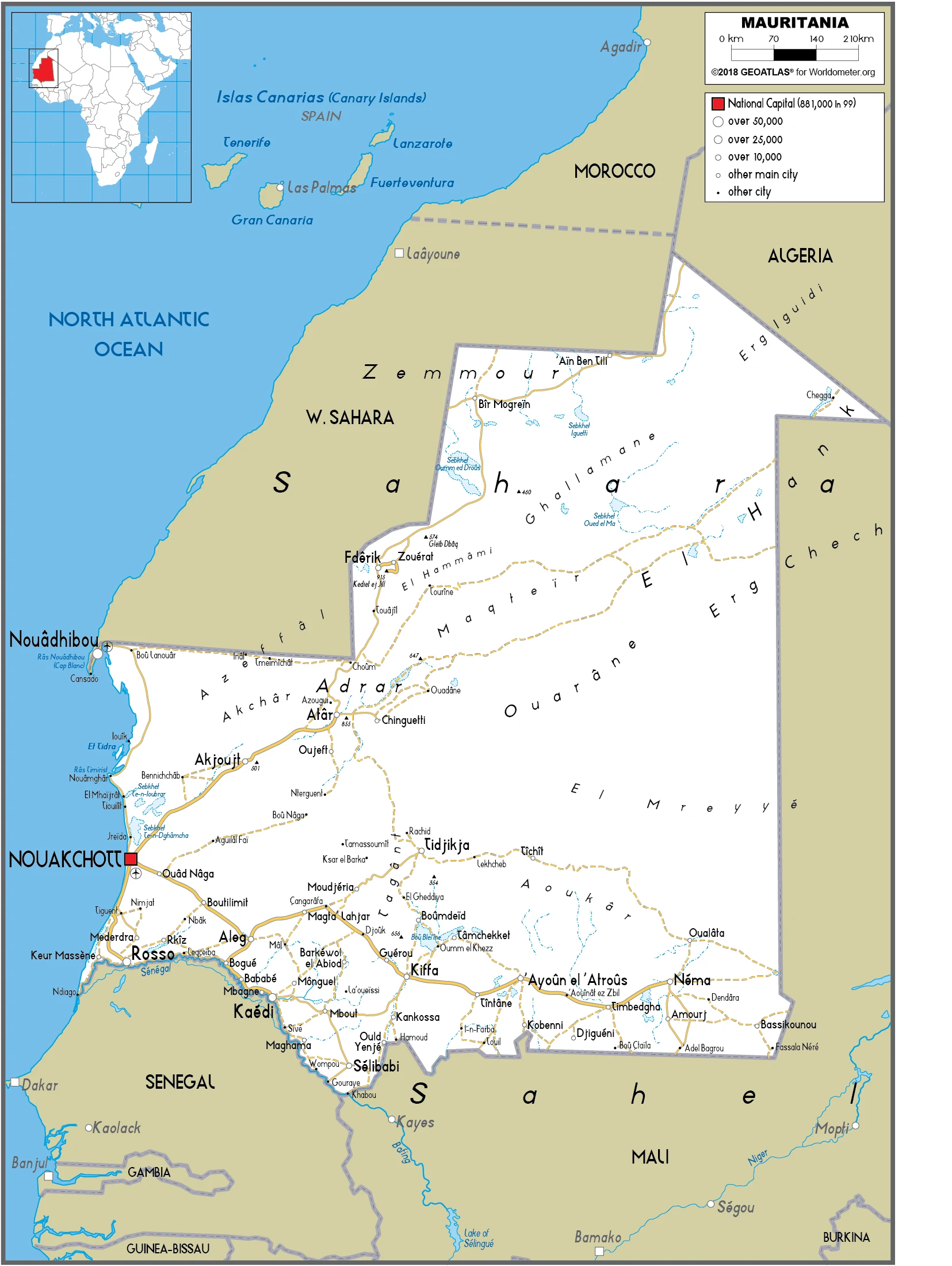
This state is located in Western Africa, bordering the North Atlantic Ocean, between Senegal and Western Sahara, under the coordinates of 20 00 N, 12 00 W, covering an area of 1,030,700 sq km with a coastline of 754 km. Mauritania is Slightly more extensive than three times the size of New Mexico; about six times the size of Florida.
Mauritania has 5,002 km of land boundaries in total and borders with (4 nations): Algeria 460 km, Mali 2236 km, Morocco 1564 km, Senegal 742 km.
Mostly barren, flat plains of the Sahara, some central hills, with Kediet Ijill 915 m as the highest point of Mauritania, while Sebkhet Te-n-Dghamcha -5 m as the lowest point, causing a mean elevation at 276 m throughout the country. With a total of 1,030,700 sq km, Mauritania has 1,030,700 sq km of land and 0 sq km water surface area.
Major water bodies in the country: The principal river is Senegal (shared with Senegal and Mali) – 1,641 km. The significant watersheds for Mauritania are Atlantic Ocean drainage: Niger (2,261,741 sq km) Senegal (456,397 sq km).
Mauritania is considered a part of North Africas Maghreb region and West Africas Sahel region; most of the population is concentrated in the cities of Nouakchott and Nouadhibou and along the Senegal River in the southern part of the country.
The climate in Mauritania is as follows: Desert, constantly hot, dry, dusty.
When you visit Mauritania, the natural hazards shall be considered: Hot, dry, dust/sand-laden sirocco wind primarily in March and April; periodic droughts.
The following major health-threatening issues shall be considered when visiting Mauritania: degree of risk: very high (2020), bacterial and protozoal diarrhea, hepatitis A, and typhoid fever, malaria, and dengue fever, rabies, meningococcal meningitis.
Current environmental issues affecting the Mauritanian people: overgrazing, deforestation, and soil erosion aggravated by drought contribute to desertification; limited natural fresh water resources away from Senegal, the only perennial river; locust infestation.
Google Maps Mauritania
The capital and other divisions
Capital city: Nouakchott found under the coordinates 18 04 N, 15 58 W, applying the time zone UTC 0 (5 hours ahead of Washington, DC, during Standard Time), using the following daylight saving time: none.
Nouakchott is a significant city in Mauritania. It is Mauritania’s capital and largest city, located 40 kilometers southwest of the capital and oldest city of Mauritius, Port Louis. French colonists founded the town in 1843 as a military post on the route to the Senegal River. Nouakchott has been home to many significant historical events that have shaped the history of Mauritania and its relations with other countries. The first constitution of Mauritania was drafted there in 1959, and it was also the site where the Mauritanian independence from France was proclaimed.
Mauritania became independent on 28 November 1960 (from France), and its national holiday is Independence Day, 28 November (1960).
Administrative divisions: 15 regions (wilayas, singular – wilaya); Adrar, Assaba, Brakna, Dakhlet Nouadhibou, Gorgol, Guidimaka, Hodh ech Chargui, Hodh El Gharbi, Inchiri, Nouakchott Nord, Nouakchott Ouest, Nouakchott Sud, Tagant, Tiris Zemmour, Trarza.
People and society
The Maures control political and economic life. Family solidarity among nomadic peoples is powerful. Ethnic tension centers on the oppression of the black minority. Tens of thousands of blacks are estimated to be in illegal slavery. Coups have interrupted civilian rule in recent years.
The population in Mauritania is 4,079,284 (July 2021 estimate), with an average of 2.02% (2021 estimate) change. That means Mauritania is the No. 128 in the world’s populated rank list. With an average of 21 years median age (20.1 years for males and 20.1 years for women), Mauritania ranks No. 187 on the globe’s median age rank list.
The people living in this country are the Mauritanian(s) (noun) or Mauritanian (adjective) and belong mainly to the following ethnic groups: Black Moors (Haratines – Arab-speaking enslaved people, formerly enslaved people, and their descendants of African origin, enslaved by white Moors) 40%, White Moors (of Arab-Berber descent, known as Beydane) 30%, Sub-Saharan Mauritanians (non-Arabic speaking, largely resident in or originating from the Senegal River Valley, including Halpulaar, Fulani, Soninke, Wolof, and Bambara ethnic groups) 30%.
They speak Arabic (official language and national), Pular, Soninke, Wolof (all national languages), French languages and practice the following religions: Muslim (official) 100%.
We can conclude the following about the population in Mauritania: With most of the country being a desert, vast areas, particularly in the central, northern, and eastern areas, are without sizeable population clusters. Half the population lives in or around the coastal capital of Nouakchott. Smaller clusters are found near the southern border with Mali and Senegal, as shown in this population distribution map. In Mauritania, we are talking about 56.1% (2021) of the total population is living in cities, and most of them reside in the following municipalities: 1.372 million, Nouakchott (capital city) (2021).
Industry
Agriculture and herding. Iron, copper, and gold mining. Worlds largest gypsum deposits. Offshore oil from 2006. Rich fishing grounds.
Mauritania’s economy is dominated by extractive industries (oil and mines), fisheries, livestock, agriculture, and services. Half the population still depends on farming and raising livestock, even though many nomads and subsistence farmers were forced into the cities by recurrent droughts in the 1970s, 1980s, 2000s, and 2017. Recently, foreign investment in the mining and oil sectors has primarily driven GDP growth. Mauritania’s extensive mineral resources include iron ore, gold, copper, gypsum, and phosphate rock, and ongoing exploration for tantalum, uranium, crude oil, and natural gas. Extractive commodities make up about three-quarters of Mauritania’s total exports, subjecting the economy to price swings in world commodity markets.
Mining is also a growing source of government revenue, rising from 13% to 30% of total revenue from 2006 to 2014. The nation’s coastal waters are among the most affluent fishing areas globally, and fishing accounts for about 15% of budget revenues and 45% of foreign currency earnings. Mauritania processes a total of 1,800,000 tons of fish per year, but overexploitation by foreign and national fleets threaten the sustainability of this crucial source of revenue., The economy is susceptible to international food and extractive commodity prices. Other risks to Mauritania’s economy include its recurring droughts, dependence on foreign aid and investment, insecurity in neighboring Mali, and significant shortages of infrastructure, institutional capacity, and human capital. In December 2017, Mauritania and the IMF agreed to a three-year agreement under the Extended Credit Facility to foster economic growth, maintain macroeconomic stability, and reduce poverty. Investment in agriculture and infrastructure are the most significant components of the country’s public expenditures.
Mauritania is rich in the following natural resources: Iron ore, gypsum, copper, phosphate, diamonds, gold, oil, fish.
The main industrial sectors are typically fish processing, oil production, mining (iron ore, gold, copper). Note: gypsum deposits have never been exploited.
The country’s export sectors are robust in iron ore, fish products, gold, mollusks, processed crustaceans (2019), partnering with these nations: China 32%, Switzerland 13%, Spain 9%, Japan 9%, Italy 5% (2019). The export trade resulted in $2.52 billion. Note: Data are in current year dollars (2019 estimate). In a global rank of the export, values resulted in Mauritania’s position of 148.
Land use in Mauritania: 0.2% (2018 estimate) forest, 61.3% (2018 estimate) other.
The arable land area is 0.4% (2018 estimate), and the agricultural land is 38.5% (2018 estimate). Land use for permanent crops 0% (2018 estimate), permanent pasture 38.1% (2018 estimate). The sum of the area of the irrigated land is 450 sq km (2012).
The main agro-industrial products of Mauritania are rice, milk, goat milk, sheep milk, sorghum, mutton, beef, camel milk, camel meat, dates.
The country typically needs to import: ships, aircraft, wheat, raw sugar, refined petroleum (2019), partnering with the following nations: China 26%, France 6%, Spain 6%, Morocco 6%, United Arab Emirates 5% (2019) in a sum value of $3.68 billion. Note: data are in current year dollars (2019 estimate) $3.28 billion. Note: data are in current year dollars (2018 estimate) $319 million (2017 estimate). This sum value on the global ranking list of imports resulted in Mauritania 153.
Mauritania Driving Directions
In this post, you learned about Mauritania, Western Africa, bordering the North Atlantic Ocean, between Senegal and Western Sahara. We published some basic information about its capital Nouakchott, and the Mauritanian nation.
Are you interested in visiting Mauritania and looking for driving directions? Click here to plan your route, or see a printable road map of Mauritania below for an overview of the route network.
Printable map of Mauritania
Did you know about Mauritania?
Mauritania is a Muslim-majority country in West Africa. It’s the second-largest country on the African continent, and most of it is covered by the Sahara Desert. France colonized Mauritania for about six decades before gaining independence in 1960. The capital city is Nouakchott, and its second-largest city is Nouadhibou. The people of Mauritania are primarily from the Arab-Berber minority, with a small population of black Africans called Bantu and Soninke.
After virtually visiting Mauritania, you may also be interested in the neighboring countries: Algeria, Mali, Morocco, Senegal.
If you liked our Google map and Mauritania information page,
please share it with others or save the link https://www.drivingdirections.net in your bookmarks.