
Paraguay Google Maps is a site/tool that offers a wide range of map views (topographic, satellite, street view) and navigation options, with little effort on your part, yet efficiently. If you need to plan a trip to a new place like Paraguay, Google maps are available on desktop, mobile, or tablet. This Google maps and information page is dedicated to Paraguay, South America (13 countries), showing its location, country facts, details about its capital city Asuncion, bordering countries like Argentina, Bolivia, and Brazil, and plenty of other information which may be interesting when you visit this South American state.
Quick links: Google Maps Paraguay, Asuncion Google maps, Driving Directions Paraguay, Printable Road Map.
About Paraguay in a nutshell
- The War of the Triple Alliance (1864-1870) killed almost 90% of Paraguays male population.
- Conventional short form of the name: Paraguay
- The conventional long form of the name: Republic of Paraguay
- Local long form: Republica del Paraguay
- Local short form: Paraguay
- Former name(s): N/A
- Etymology: the precise meaning of the name Paraguay is unclear, but it seems to derive from the river of the same name; one explanation has the name means water of the Payagua (an indigenous tribe that lived along the river).
- The legal system in Paraguay: civil law system with influences from Argentine, Spanish, Roman, and French civil law models; judicial review of legislative acts in the Supreme Court of Justice.
- Climate: Subtropical. The Gran Chaco is generally hotter and drier. All areas experience floods and droughts.
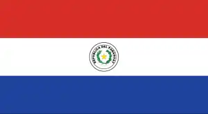
- The national symbol is a lion. The national colors are red, white, and blue.
- Internet TLD: .py
The vast majority of Paraguay’s inhabitants are descendants of the Guaraní Indians who call the Paraná and Paraguay Rivers and the dry savannah of the Gran Chaco their home. They inhabited the area even before the first Europeans arrived in the early 16th century. The peaceful indigenous people got on well with the Spanish settlers and Jesuit missionaries: the Guaraní gradually mixed with the Spanish, adopting each other’s customs and learning each other’s languages. After a while, a prosperous Spanish-Guaraní society emerged, with the Spanish taking the political leaders and the Meshtic population adopting Spanish cultural values. Colonialism also brought the arrival of the missionaries: the indigenous communities lived in fortified missionary communes, or “reductions”, which for about 150 years became a flourishing “Jesuit state”. In 1767 the Spanish king expelled the Jesuits, and with it, the peaceful life of the Guaraní came to an end. Independence in 1811 was followed by dictatorships, invasions, and struggles for freedom, and in the second half of the 20th century, by a policy of isolation. The World Heritage-listed ruins of the missionary towns of Trinidad de Parana and Jesus de Tavarangue are a reminder of the heyday of the peaceful spread of Christianity.
Background
Paraguay achieved its independence from Spain in 1811. In the disastrous War of the Triple Alliance (1865-1870) – between Paraguay and Argentina, Brazil, and Uruguay – Paraguay lost two-thirds of its adult males and much of its territory. The country stagnated economically for the next half-century. Following the Chaco War of 1932-1935 with Bolivia, Paraguay gained a large part of the Chaco lowland region. The 35-year military dictatorship of Alfredo STROESSNER ended in 1989, and Paraguay has held relatively free and regular presidential elections since the country’s return to democracy.
Geography
The Paraguay River divides the hilly and forested east from a flat alluvial plain, with marsh and semidesert scrub land in the west.
Landlocked in central South America and once a Spanish colony, Paraguays post-independence history has included periods of military rule. Free elections have been held since 1993.
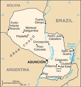
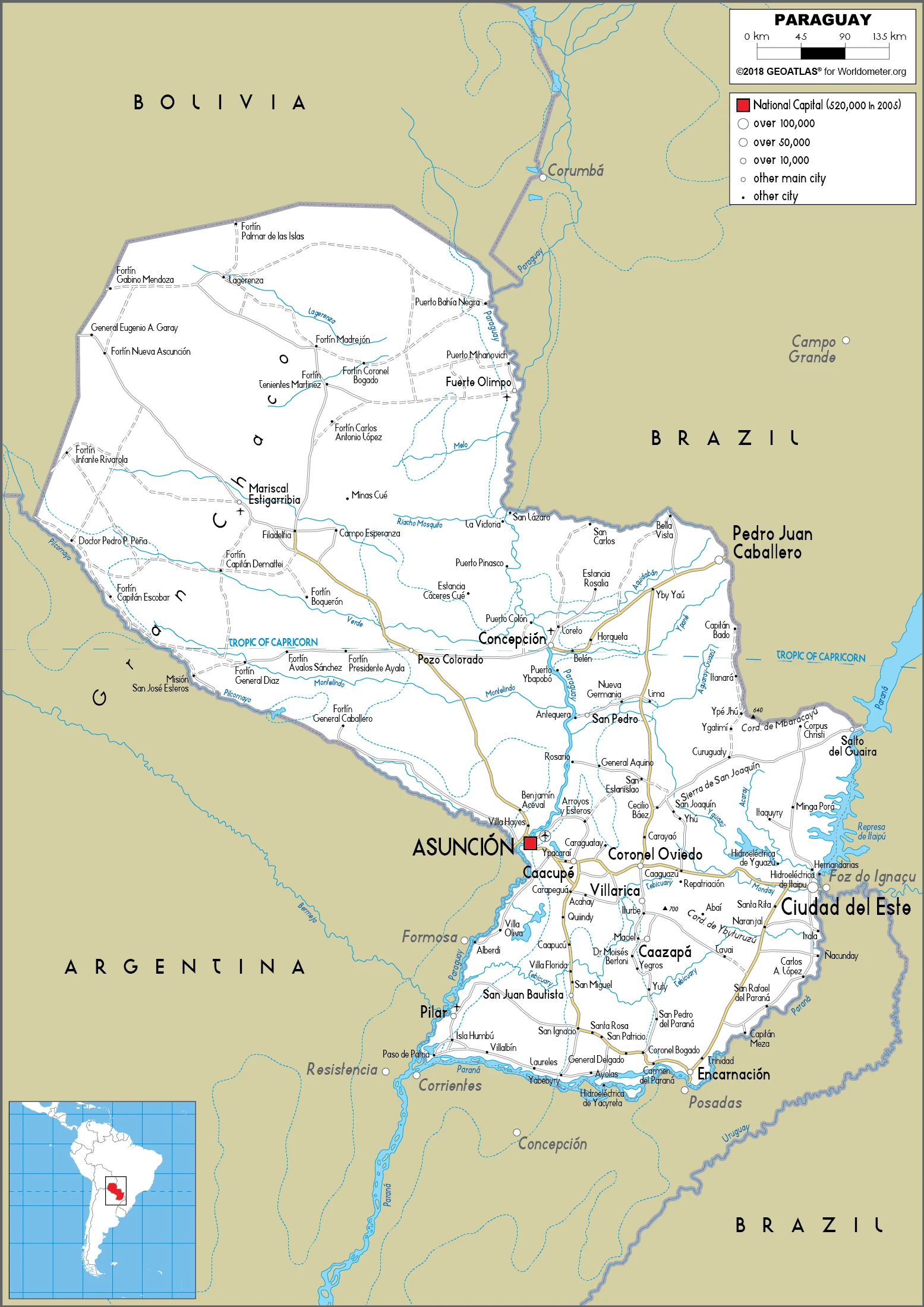
This state is located in Central South America, northeast of Argentina, southwest of Brazil, under the coordinates of 23 00 S, 58 00 W, covering an area of 406,752 sq km with a coastline of 0 km (landlocked country). Paraguay is About three times the size of New York state, slightly smaller than California.
Paraguay has 4,655 km of land boundaries in total and bordering with (3 nations): Argentina 2531 km, Bolivia 753 km, and Brazil 1371 km.
Grassy plains and wooded hills east of Rio Paraguay, Gran Chaco region west of Rio Paraguay mostly low, marshy plain near the river, and dry forest and thorny scrub elsewhere, with Cerro Pero 842 m as the highest point of Paraguay, while junction of Rio Paraguay and Rio Parana 46 m as the lowest point, causing a mean elevation at 178 m throughout the country. With a total of 406,752 sq km, Paraguay has 397,302 sq km of land and 9,450 sq km of water surface area.
The principal rivers are Rio de la Plata/Parana (shared with Brazil, Argentina, Uruguay, and Bolivia) – 4,880 km, and Paraguay (shared with Brazil and Argentina) – 2,549 km. The significant watersheds for Paraguay are Atlantic Ocean drainage: Paraná (2,582,704 sq km).
Landlocked; lies between Argentina, Bolivia, and Brazil; population concentrated in the eastern and southern part of the country.
The climate in Paraguay is as follows: Subtropical to temperate, with substantial rainfall in the eastern portions, becoming semiarid in the far west.
When you visit Paraguay, the natural hazards shall be considered: Local flooding in the southeast (early September to June); poorly drained plains may become boggy (early October to June).
The following major health-threatening issues shall be considered when visiting Paraguay: Degree of risk: intermediate (2020), bacterial diarrhea, hepatitis A, typhoid fever, and dengue fever.
Current environmental issues affecting the Paraguayan people: deforestation; water pollution; rivers suffering from toxic dumping; tanneries releasing mercury and chromium into rivers and streams; loss of wetlands; inadequate means for waste disposal pose health risks for many urban residents.
Google Maps Paraguay
The capital and other divisions
Capital city: Asuncion found under the coordinates 25 16 S, 57 40 W, applying the time zone UTC-4 (1 hour ahead of Washington, DC, during Standard Time), using the following daylight saving time: +1hr, begins first Sunday in October; ends last Sunday in March.
Asuncion is a city in Paraguay, and it is the capital. It is known for being near the border of Brazil and Argentina. Asuncion is the third-largest city in South America by population, located on the country’s main branch of the Paraná River and near its outlet to the Atlantic Ocean. At the same time, Asuncion contains plenty of interesting features and sights worth exploring on your trip to the city.
Paraguay became independent on 14-15 May 1811 (from Spain), and its national holiday is Independence Day, 14-15 May (1811) (observed 15 May); 14 May is celebrated as Flag Day.
Administrative divisions: 17 departments (departamentos, singular – departamento) and 1 capital city; Alto Paraguay, Alto Parana, Amambay, Asuncion, Boqueron, Caaguazu, Caazapa, Canindeyu, Central, Concepcion, Cordillera, Guaira, Itapua, Misiones, Neembucu, Paraguari, Presidente Hayes, San Pedro.
People and society
The population is mainly mestizo (mixed Spanish and native Guaraní origin). Most people are bilingual, though, in rural areas, Guaraní is more widely used. Cattle ranchers populate the Chaco and communities of the German-origin Mennonite Church. Right-wing Colorados were in power for decades, except from 2008-2012.
The population in Paraguay is 7,272,639 (July 2021 estimate), with an average of 1.15% (2021 estimate) change. That means Paraguay is the No. 103 in the world’s populated rank list. With an average of 29.7 years median age (29.5 years for males and 29.5 years for women), Paraguay ranks No. 128 on the globe’s median age list.
The people living in this country are the Paraguayan(s) (noun) or Paraguayan (adjective) and belong mainly to the following ethnic groups: Mestizo (mixed Spanish and Amerindian) 95%, other 5%.
They speak Spanish (official language) and Guarani (official language) 46.3%, only Guarani 34%, only Spanish 15.2%, other (includes Portuguese, German, and other indigenous languages) 4.1%, no response 0.4%; languages and practice the following religions: Roman Catholic 89.6%, Protestant 6.2%, other Christian 1.1%, other or unspecified 1.9%, none 1.1% (2002 estimate).
We can conclude the following about the population in Paraguay: Most of the population resides in the eastern half of the country. To the west lies the Gran Chaco (a semiarid lowland plain), which accounts for 60% of the land territory, but only 2% of the overall population. In Paraguay, we are talking about 62.5% (2021) of the total population living in cities, and most of them reside in the following municipalities: 3.394 million, Asuncion (capital city) (2021).
Industry
Agriculture: soybeans are the main export. Electricity is exported from massive hydroelectric dams, including Itaipú (the worlds second-largest, jointly run with Brazil). Large informal economy. Corruption and smuggling.
Landlocked Paraguay has a market economy distinguished by a large informal sector, featuring the re-export of imported consumer goods to neighboring countries and the activities of thousands of microenterprises and urban street vendors. A large percentage of the population, especially in rural areas, derives its living from agricultural activity, often subsistence. Because of the importance of the informal sector, accurate economic measures are difficult to obtain. On a per capita basis, real income has grown steadily over the past five years. Strong world demand for commodities, high prices, and favorable weather supported Paraguay’s commodity-based export expansion.
Paraguay is the fifth largest soy producer in the world. Drought-hit in 2008, reducing agricultural exports and slowing the economy even before the global recession. The economy fell 3.8% in 2009, as lower world demand and commodity prices caused exports to contract. Severe drought and outbreaks of hoof-and-mouth disease in 2012 led to a brief drop in beef and other agricultural exports. Since 2014, however, Paraguay’s economy has grown at a 4% average annual rate due to strong production and high global prices at a time when other countries in the region have contracted. The Paraguayan Government recognizes the need to diversify its economy and has taken steps in recent years. In addition to looking for new commodity markets in the Middle East and Europe, Paraguayan officials have promoted the country’s low labor costs, cheap energy from its massive Itaipu Hydroelectric Dam, and single-digit tax rate on foreign firms.
As a result, the number of factories operating in the country primarily transplants from Brazil – has tripled since 2014. Corruption, limited progress on structural reform, and deficient infrastructure are the main obstacles to long-term growth. Judicial corruption is endemic and is seen as the most significant barrier to attracting more foreign investment. Paraguay has been averse to public debt throughout its history but has recently sought to finance infrastructure improvements to attract foreign investment.
Paraguay is rich in the following natural resources: Hydropower, timber, iron ore, manganese, and limestone.
The main industrial sectors are sugar processing, cement, textiles, beverages, wood products, steel, base metals, and electric power.
The country’s export sectors are particularly strong in soybeans and soybean products, electricity, beef, corn, and insulated wiring (2019), partnering with these nations: Brazil 32%, Argentina 22%, Chile 8%, Russia 8% (2019). The export trade resulted in $11.81 billion. Note: Data are in current year dollars (2020 estimate). In a global rank of the export, values resulted in Paraguay’s position of 98.
Land use in Paraguay: 43.8% (2018 estimate) forest, 2.4% (2018 estimate) other.
The arable land area is 10.8% (2018 estimate), and the agricultural land is 53.8% (2018 estimate). Land use for permanent crops is 0.2% (2018 estimate), and permanent pasture is 42.8% (2018 estimate). The sum of the area of the irrigated land is 1,362 sq km (2012).
The main agro-industrial products of Paraguay are soybeans, sugar cane, maize, cassava, wheat, rice, beef, milk, oranges, and oil palm fruit.
The country typically needs to import: broadcasting equipment, cars, pesticides, refined petroleum, and tires (2019), partnering with the following nations: Brazil 24%, the United States 22%, China 17%, Argentina 10%, Chile 5% (2019) in a sum value of $10.62 billion. Note: data are in current year dollars (2020 estimate) $13.15 billion. Note: data are in current year dollars (2019 estimate) $13.88 billion. Note: data are in current year dollars (2018 estimate). This sum value on the global ranking list of imports resulted in Paraguay 104.
Paraguay Driving Directions
In this post, you learned about Paraguay, Central South America, northeast Argentina, and southwest Brazil. We published some basic information about its capital Asuncion, and the Paraguayan nation.
Are you interested in visiting Paraguay and looking for driving directions? Click here to plan your route, or see a printable road map of Paraguay below for an overview of the route network.
Printable map of Paraguay
Did you know about Paraguay?
- Did you know that Paraguay is a landlocked country in South America, bordered by Argentina, Brazil, and Bolivia?
- Did you know that Paraguay is one of the few countries in the world with both a presidential and a parliamentary system of government?
- Did you know that Paraguay has a rich cultural heritage, with indigenous influences from the Guaraní people and Spanish and European influences from its colonial past?
- Did you know that Paraguay is one of the world’s largest hydroelectric power producers due to the extensive network of dams and hydroelectric power plants on the Paraguay River?
- Did you know that Paraguay is also a significant exporter of soybeans and beef and has a rapidly growing agricultural sector?
- Did you know that Paraguay is home to several national parks and wildlife reserves, including the Chaco National Park, which is home to a wide variety of wildlife, including jaguars, pumas, and tapirs?
- Did you know that Paraguay is famous for its traditional music, including the lively paragüero style of folk music, as well as its traditional dances, such as the Paraguayan polka and the bottle dance?
After virtually visiting Paraguay, you may also be interested in the neighboring countries: Argentina, Bolivia, and Brazil.
If you liked our Google map and Paraguay information page,
please share it with others or save the link https://www.drivingdirections.net in your bookmarks.