
Wallis and Futuna Google Maps is a site/tool that offers a wide range of map views (topographic, satellite, street view) and navigation options, with little effort on your part, yet efficiently. If you need to plan a trip to a new place like Wallis and Futuna, Google maps are available on desktop, mobile, or tablet. This Google maps and information page is dedicated to Wallis and Futuna, Oceania (27 countries), showing its location, country facts, details about its capital city Mata-Utu, bordering countries like none, and plenty of other information which may be interesting when you visit this Oceanian state.
Quick links: Google Maps Wallis and Futuna, Mata-Utu Google maps, Driving Directions Wallis and Futuna, Printable Road Map.
About Wallis and Futuna in a nutshell
- Conventional short form of the name: Wallis and Futuna
- The conventional long form of the name: Territory of the Wallis and Futuna Islands
- Local long form: Territoire des Iles Wallis et Futuna
- Local short form: Wallis et Futuna
- Former name(s): the Hoorn Islands is the former name of the Futuna Islands
- Etymology: Wallis Island is named after British Captain Samuel WALLIS, who discovered it in 1767; Futuna is derived from the native word futu, the name of the fish-poison tree found on the island.
- The legal system in Wallis and Futuna: French civil law World the legal systems of nearly all countries are generally modeled upon elements of five primary types: civil law (including French law, the Napoleonic Code, Roman law, Roman-Dutch law, and Spanish law); common law (including English and U.S. law); customary law; mixed or pluralistic law; and religious law (including Islamic sharia law); an additional type of legal system – international law – governs the conduct of independent nations in their relationships with one another.
- Climate: N/A
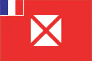
- The national symbols are red saltire (Saint Andrews Cross) on a white square on a red field; national colors: red and white.
- Internet TLD: .wf
Background
The first humans settled Wallis and Futuna around 800 B.C. The islands were a natural midpoint between Fiji and Samoa. Around A.D. 1500, Tongans invaded Wallis and a chiefdom system resembling Tonga’s formal hierarchy developed on the island. Tongans attempted to settle Futuna but were repeatedly rebuffed. Samoans settled Futuna in the 1600s, and a slightly less centralized chiefdom system formed. Dutch explorers were the first Europeans to see the islands in 1616, followed intermittently by other Europeans, including British explorer Samuel WALLIS in 1767. French Catholic missionaries were the first Europeans to settle Wallis and Futuna in 1837 permanently. The missionaries converted most of the population of Wallis by 1842 and of Futuna by 1846. The missionaries and newly-converted King LAVELUA of Uvea on Wallis asked France for a protectorate in 1842 following a rebellion of locals. France agreed although the protectorate status would not be ratified until 1887. In 1888, King MUSULAMU of Alo and King TAMOLE of Sigave, both on Futuna, signed a treaty establishing a French protectorate.
The Wallis and Futuna protectorate was integrated into the territory of New Caledonia that same year. France renegotiated the terms of the protectorate with the territory’s three kings in 1910, expanding French authority. Wallis and Futuna was the only French colony to side with the Vichy regime during World War II until Free French, and U.S. troops arrived in 1942. In 1959, inhabitants of the islands voted to separate from New Caledonia and become a French overseas territory, a status it assumed in 1961. Despite the split, a significant Wallisian and Futunan community still live in New Caledonia. In 2003, Wallis and Futuna’s designation changed to that of an overseas collectivity. Wallis and Futuna became associate members of the Pacific Islands Forum in 2018, two years after Frances’s and other Pacific territories became full members of the organization.
Geography
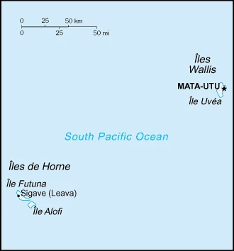
Wallis and Futuna is a group of Islands in the south pacific. They are considered the last piece of the “Polynesian triangle”.
This state is located in Oceania, islands in the South Pacific Ocean, about two-thirds of the way from Hawaii to New Zealand, under the coordinates of 13 18 S, 176 12 W, covering an area of 142 sq km with a coastline of 129 km. Wallis and Futuna is 1.5 times the size of Washington, DC.
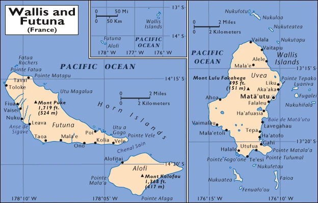
Volcanic origin, low hills, with Mont Singavi (on Futuna) 522 m as the highest point of Wallis and Futuna, while Pacific Ocean 0 m as the lowest point, causing a mean elevation at N/A throughout the country. With a total of 142 sq km, Wallis and Futuna have 142 sq km of land and 0 sq km of water surface area.
Both island groups have fringing reefs; Wallis contains several prominent crater lakes.
The climate in Wallis and Futuna is as follows: Tropical, hot, rainy season (November to April), cool, dry season (May to October), rains 250-300 cm per year (80% humidity), the average temperature of 26.6 degrees celsius.
When you visit Wallis and Futuna, the natural hazards shall be considered: Cyclones; tsunamis.
The following major health-threatening issues shall be considered when visiting Wallis and Futuna: high (2020) degree of risk, bacterial diarrhea, and malaria.
Current environmental issues affecting the Wallisian, Futunan, or Wallis and Futuna Islander people: deforestation (only small portions of the original forests remain) primarily as a result of the continued use of wood as the primary fuel source; as a consequence of cutting down the forests, the mountainous terrain of Futuna is particularly prone to erosion; there are no permanent settlements on Alofi because of the lack of natural freshwater resources; lack of soil fertility on the islands of Uvea and Futuna negatively impacts agricultural productivity.
Google Maps Wallis and Futuna
The capital and other divisions
Capital city: Mata-Utu (on Ile Uvea) found under the coordinates 13 57 S, 171 56 W, using the following daylight saving time: none.
Mata-Utu is the capital of Ile Uvea, an island in the Tuamoto archipelago. The population is just over 2,000, and there are no cars or roads on the island. Mata-Utu is a relatively small village with a few stores, restaurants, and cafes.
Wallis and Futuna became independent on none (overseas collectivity of France), and its national holiday is Bastille Day, 14 July (1789).
Administrative divisions: 3 administrative precincts (circonscriptions, singular – circonscription) Alo, Sigave, Uvea World 195 countries, 71 dependent areas, and other entities.
People and society
The population in Wallis and Futuna is 15,851 (July 2021 estimate), with an average of 0.26% (2021 estimate) change. That means Wallis and Futuna is the No. 220 in the world’s populated rank list. With an average of 34 years median age (33.1 years for males and 33.1 years for women), Wallis and Futuna rank No. 93 on the globe’s median age rank list.
The people living in this country are the Wallisian(s), Futunan(s), or Wallis and Futuna Islanders (noun) or Wallisian, Futunan, or Wallis and Futuna Islander (adjective) and belong mainly to the following ethnic groups: Polynesian.
They speak Wallisian (an indigenous Polynesian language) 58.9%, Futunian 30.1%, French (official language) 10.8%, other 0.2% (2003 census) languages and practice the following religions: Roman Catholic 99%, other 1%.
We can conclude the following about the population in Wallis and Futuna: In Wallis and Futuna, we are talking about 0% (2021) of the total population is living in cities, and most of them reside in the following municipalities: 1,000 Mata-Utu (capital city) (2018).
Industry
The economy is limited to traditional subsistence agriculture, with about 80% of labor force earnings coming from agriculture (coconuts and vegetables), livestock (mainly pigs), and fishing. However, roughly 70% of the labor force is employed in the public sector, although only about a third of the population is in salaried employment. Revenues come from French Government subsidies, licensing of fishing rights to Japan and South Korea, import taxes, and remittances from expatriate workers in New Caledonia. France directly finances the public sector and healthcare and education services. It also provides funding for key development projects in various areas, including infrastructure, economic development, environmental management, and healthcare facilities. A key concern for Wallis and Futuna is an aging population with consequent economic development issues. Very few people aged 18-30 live on the islands due to the limited formal employment opportunities. Improving job creation is a current priority for the territorial government.
Wallis and Futuna is rich in the following natural resources: N/A.
The main industrial sectors are copra, handicrafts, fishing, and lumber.
The country’s export sectors are particularly strong in integrated circuits, jewelry, cars, aircraft parts, and polyacetals (2019), partnering with these nations: Singapore 47%, France 32%, Belgium 9% (2019). The export trade resulted in $47,450. Note: Data are in current year dollars (2004 estimate). In a global export rank, values resulted in Wallis and Futuna’s position of 226.
Land use in Wallis and Futuna: 41.9% (2018 estimate) forest, 15.3% (2018 estimate) other.
The arable land area is 7.1% (2018 estimate), and the agricultural land is 42.8% (2018 estimate). Land use for permanent crops 35.7% (2018 estimate), permanent pasture 0% (2018 estimate). The area of the irrigated land is 0 sq km (2012).
The main agro-industrial products of Wallis and Futuna are coconuts, breadfruit, yams, taro, bananas, pigs, goats, and fish.
The country typically needs to import: refined petroleum, beef products, poultry meats, engine parts, and packaged medicines (2019), partnering with the following nations: France 43%, Fiji 24%, New Zealand 11%, Australia 6% (2019) in a sum value of $61.17 million (2004 estimate). This sum value on the global ranking list of imports resulted in Wallis and Futuna 222.
Wallis and Futuna Driving Directions
In this post, you learned about Wallis and Futuna, Oceania, islands in the South Pacific Ocean, about two-thirds of the way from Hawaii to New Zealand. We published some basic information about its capital Mata-Utu (on Ile Uvea), and the Wallisian, Futunan, or Wallis and Futuna Islander nations.
Are you interested in visiting Wallis and Futuna and looking for driving directions? Click here to plan your route, or see a printable road map of Wallis and Futuna below for an overview of the route network.
Printable map of Wallis and Futuna
Did you know about Wallis and Futuna?
Wallis and Futuna are two small islands in the South Pacific. They are located about halfway between Hawaii and New Zealand. Despite their small size, these islands are home to a diverse range of wildlife. There are over 100 different species of birds, including the red-tailed tropicbird. The islands are also home to several reptiles, including the skink and the gecko.
After virtually visiting Wallis and Futuna, you may also be interested in the neighboring countries: none.
If you liked our Google map and Wallis and Futuna information page,
please share it with others or save the link https://www.drivingdirections.net in your bookmarks.