
Zambia Google Maps is a site/tool that offers a wide range of map views (topographic, satellite, street view) and navigation options, with little effort on your part, yet efficiently. If you need to plan a trip to a new place like Zambia, Google maps are available on desktop, mobile, or tablet. This Google maps and information page is dedicated to Zambia, Africa (54 countries), showing its location, country facts, and details about its capital city Lusaka, bordering countries like Angola, Botswana, the Democratic Republic of the Congo, Malawi, Mozambique, Namibia, Tanzania, Zimbabwe, and plenty of other information which may be interesting when you visit this African state.
Quick links: Google Maps Zambia, Lusaka Google maps, Driving Directions Zambia, Printable Road Map.
About Zambia in a nutshell
- Conventional short form of the name: Zambia
- The conventional long form of the name: Republic of Zambia
- Former name(s): Northern Rhodesia
- Etymology: name is derived from the Zambezi River, which flows through the western part of the country and forms its southern border with neighboring Zimbabwe.
- The legal system in Zambia: mixed legal system of English common law and customary law.
- Climate: Tropical, with three seasons: cool and dry, hot and dry, and wet. Southwest is prone to drought.
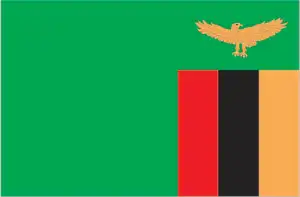
- The national symbols are the African fish eagle; the national colors: are green, red, black, and orange.
- Internet TLD: .zm
Zambia, a landlocked country in the Central African Highlands, has a capital city home to a tenth of its population. Its population is relatively diverse. Zambia lies in the tropical belt, but its climate is particularly favorable due to its altitude. Its stunningly beautiful national parks are bordered by the Zambezi and its major tributaries, the Luangwa and the Kafue. Where the fourth longest river on the continent plunges into a hundred-meter-deep crevasse carved into the lava of the Batoka Plateau, the gushing waters of the savannah forest and the roar of the falling waters have long been known to the people living along the river: the falls were known by the Makoloi as the “Mosi-oa-Tunya”, or “thundering steam”. In November 1855, the first European to see it, David Livingstone, christened it Victoria, after the then monarch of the British Empire. The waterfall is shared with Zambia’s southern neighbor, Zimbabwe. The immediate area around the falls on both sides is a national park, a UNESCO World Heritage Site.
Spray from Musi-o-Tunya (Victoria Falls) can be seen up to 20 miles (35 km) away.
Background
Multiple waves of Bantu-speaking groups moved into and through what is now Zambia over the past thousand years. In the 1880s, the British began securing mineral and other economic concessions from local leaders. The territory, now Zambia, eventually came under the control of the former British South Africa Company and was incorporated as the protectorate of Northern Rhodesia in 1911. The UK took over administrative control in 1924. During the 1920s and 1930s, advances in mining spurred development and immigration. The name was changed to Zambia upon independence in 1964. In the 1980s and 1990s, declining copper prices, economic mismanagement, and a prolonged drought hurt the economy. Elections in 1991 ended one-party rule and propelled the Movement for Multiparty Democracy (MMD) to government. However, the subsequent vote in 1996 saw increasing harassment of opposition parties and abuse of state media and other resources. The election in 2001 was marked by administrative problems, with three parties filing a legal petition challenging the election of ruling party candidate Levy MWANAWASA.
MWANAWASA was reelected in 2006 in an election deemed free and fair. Upon his death in August 2008, he was succeeded by his vice president, Rupiah BANDA, who won a special presidential byelection later that year. The MMD and BANDA lost to the Patriotic Front (PF) and Michael SATA in the 2011 general elections. SATA, however, presided over haphazard economic management and attempted to silence opposition to PF policies. SATA died in October 2014 and was succeeded by his vice president, Guy SCOTT, who served as interim president until January 2015, when Edgar LUNGU won the presidential byelection and completed SATA’s term. LUNGU then won a full term in the August 2016 presidential elections. Hakainde HICHILEMA was elected president in August 2021.
Geography
A high savanna plateau, broken by mountains in the northeast. The vegetation is mainly trees and scrub.
Bordered to the south by the Zambezi River, Zambia lies at the heart of southern Africa. In 1991, it peacefully transitioned from single-party rule to multiparty democracy.
This state is located in Southern Africa, east of Angola, south of the Democratic Republic of the Congo, under the coordinates of 15 00 S, 30 00 E, covering an area of 752,618 sq km with a coastline of 0 km (landlocked country). Zambia is Almost five times the size of Georgia, slightly larger than Texas.
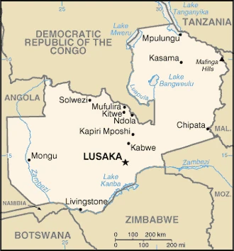
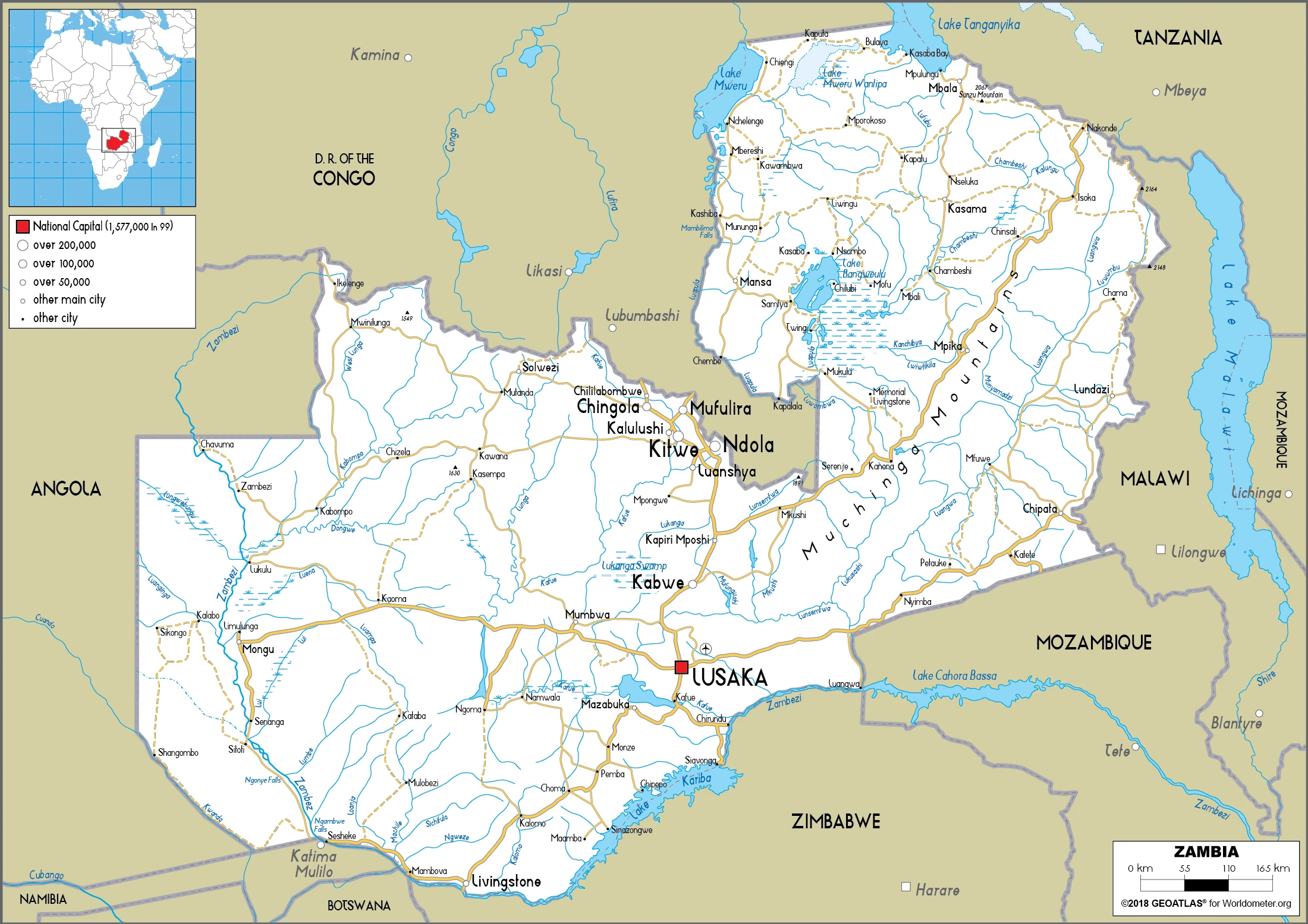
Zambia has 6,043.15 km of land boundaries in total and borders (8 nations): Angola 1065 km, Botswana 0.15 km, the Democratic Republic of the Congo 2332 km, Malawi 847 km, Mozambique 439 km, Namibia 244 km, Tanzania 353 km, Zimbabwe 763 km.
Mostly high plateau with some hills and mountains, with Mafinga Central at 2,330 m as the highest point of Zambia, while Zambezi river at 329 m as the lowest point, causing a mean elevation of 1,138 m throughout the country. With 752,618 sq km, Zambia has 743,398 sq km of land and 9,220 sq km of water surface area.
Major water bodies in the country: Lake Tanganyika (shared with the Democratic Republic of Congo, Tanzania, and Burundi) – 32,000 sq km; Lake Mweru (shared with the Democratic Republic of Congo) – 4,350 sq km; Lake Bangweulu – 4,000-15,000 sq km seasonal variation (a freshwater lake), while the major rivers are: Congo river source (shared with Angola, Republic of Congo, and the Democratic Republic of Congo m) – 4,700 km, Zambezi river source (shared with Angola, Namibia, Botswana, Zimbabwe, and Mozambique) – 2,740 km. The significant watersheds for Zambia are the Atlantic Ocean drainage: Congo (3,730,881 sq km) and Indian Ocean drainage: Zambezi (1,332,412 sq km).
Landlocked, the Zambezi forms a natural riverine boundary with Zimbabwe; Lake Kariba on the Zambia-Zimbabwe border forms the world’s largest reservoir by volume (180 cu km; 43 cu mi).
The climate in Zambia is as follows: Tropical, modified by altitude, and the rainy season (October to April).
When you visit Zambia, periodic drought and tropical storms (November to April) are natural hazards.
The following major health-threatening issues shall be considered when visiting Zambia: degree of risk: very high (2020), bacterial and protozoal diarrhea, hepatitis A, typhoid fever, malaria, dengue fever, schistosomiasis, rabies.
Current environmental issues affecting the Zambian people: air pollution and resulting acid rain in the mineral extraction and refining region; chemical runoff into watersheds; loss of biodiversity; poaching seriously threatens rhinoceros, elephant, antelope, and large cat populations; deforestation; soil erosion; desertification; lack of adequate water treatment presents human health risks.
Google Maps Zambia
The capital and other divisions
Capital city: Lusaka found under the coordinates 15 25 S, 28 17 E, applying the time zone UTC+2 (7 hours ahead of Washington, DC, during Standard Time), using the following daylight saving time: none.
Lusaka is the capital of Zambia; it was built in 1956. Previously, the capital was called Fort Jameson. Lusaka started to develop in the 1940s when copper mining became popular and became an important center for trade and transportation within Zambia. It is also considered to be the largest city in southern Africa. Lusaka is actually three cities: Apollo, Kaunda, and Kasama.
Zambia became independent on 24 October 1964 (from the UK), and its national holiday is Independence Day, 24 October (1964).
Administrative divisions: 10 provinces; Central, Copperbelt, Eastern, Luapula, Lusaka, Muchinga, Northern, North-Western, Southern, and Western.
People and society
There are more than 70 different ethnic groups, but there are fewer tensions than in many African states. Primary groups are the Bemba (in the northeast), Tonga (south), Nyanja (east), and Lozi (in the west). There are also thousands of refugees, mainly from the DRC and Angola. A National Gender Policy was issued in 2000 to redress inequalities between the sexes. The standard of living has fallen in real terms since independence. One in seven adults is infected with HIV/AIDS.
The population in Zambia is 19,077,816 (July 2021 estimate). Note: estimates for this country explicitly take into account the effects of excess mortality due to AIDS; this can result in lower life expectancy, higher infant mortality, higher death rates, lower population growth rates, and changes in the distribution of the population by age and sex than would otherwise be expected, with an average of 2.93% (2021 estimate) change. That means Zambia is the No. 65 in the world’s populated rank list. With an average of 16.9 years median age (16.7 years for males and 16.7 years for women), Zambia ranks No. 220 on the globe’s median age list.
The people living in this country are the Zambian(s) (noun) or Zambian (adjective) and belong mainly to the following ethnic groups: Bemba 21%, Tonga 13.6%, Chewa 7.4%, Lozi 5.7%, Nsenga 5.3%, Tumbuka 4.4%, Ngoni 4%, Lala 3.1%, Kaonde 2.9%, Namwanga 2.8%, Lunda (North Western) 2.6%, Mambwe 2.5%, Luvale 2.2%, Lamba 2.1%, Ushi 1.9%, Lenje 1.6%, Bisa 1.6%, Mbunda 1.2%, other 13.8%, unspecified 0.4% (2010 estimate).
They speak Bemba 33.4%, Nyanja 14.7%, Tonga 11.4%, Lozi 5.5%, Chewa 4.5%, Nsenga 2.9%, Tumbuka 2.5%, Lunda (North Western) 1.9%, Kaonde 1.8%, Lala 1.8%, Lamba 1.8%, English (official language) 1.7%, Luvale 1.5%, Mambwe 1.3%, Namwanga 1.2%, Lenje 1.1%, Bisa 1%, other 9.7%, unspecified 0.2% (2010 estimate). Note: Zambia is said to have over 70 languages, although many of these may be considered dialects; all of Zambia’s major languages are members of the Bantu family; Chewa and Nyanja are mutually intelligible dialects languages and practice the following religions: Protestant 75.3%, Roman Catholic 20.2%, other 2.7% (includes Muslim Buddhist, Hindu, and Bahai), none 1.8% (2010 estimate).
We can conclude the following about the population in Zambia: One of Africa’s highest levels of urbanization. This population distribution map shows high density in the central area, particularly around the cities of Lusaka, Ndola, Kitwe, and Mufulira. In Zambia, we are talking about 45.2% (2021) of the total population living in cities, and most of them reside in the following municipalities: 2.906 million, Lusaka (capital city) (2021).
Industry
Copper: output has risen since 2000, when decades of falling global prices ended.
New agricultural exports, notably flowers. Debt relief.
Zambia had one of the world’s fastest-growing economies for the ten years up to 2014, with real GDP growth averaging roughly 6.7% per annum. However, growth slowed from 2015 to 2017 due to falling copper prices, reduced power generation, and kwacha depreciation. Zambia’s lack of economic diversification and dependency on copper as its sole major export makes it vulnerable to fluctuations in the world commodities market. Prices turned downward in 2015 due to declining demand from China; the Democratic Republic of Congo overtook Zambia as Africa’s largest copper producer. GDP growth picked up in 2017 as mineral prices rose. Despite recent strong economic growth and its status as a lower-middle-income country, widespread and extreme rural poverty and high unemployment remain significant problems, made worse by a high birth rate, a relatively high HIV/AIDS burden, market-distorting agricultural and energy policies, and growing government debt. Zambia raised $7 billion from international investors by issuing separate sovereign bonds in 2012, 2014, and 2015. Concurrently, it issued over $4 billion in domestic debt and agreed to Chinese-financed infrastructure projects, significantly increasing its public debt burden to more than 60% of GDP. The government has considered refinancing $3 billion worth of Eurobonds and significant Chinese loans to cut debt servicing costs.
Zambia is rich in natural resources: Copper, cobalt, zinc, lead, coal, emeralds, gold, silver, uranium, and hydropower.
The main industrial sectors are copper mining and processing, emerald mining, construction, foodstuffs, beverages, chemicals, textiles, fertilizer, and horticulture.
The country’s export sectors are robust in copper, gold, gemstones, sulfuric acid, raw sugar, and tobacco (2019), partnering with these nations: Switzerland 29%, China 16%, Namibia 12%, the Democratic Republic of the Congo 9%, Singapore 5% (2019). The export trade resulted in $8.55 billion. Note: Data are in current year dollars (2020 estimate). In a global export rank, values resulted in Zambia’s position of 105.
Land use in Zambia: 66.3% (2018 estimate) forest, 2% (2018 estimate) other.
The arable land area is 4.8% (2018 estimate), and the agricultural land is 31.7% (2018 estimate). Land use for permanent crops is 0% (2018 estimate), and permanent pasture is 26.9% (2018 estimate). The sum of the area of the irrigated land is 1,560 sq km (2012).
The main agro-industrial products of Zambia are sugar cane, cassava, maize, milk, vegetables, soybeans, beef, tobacco, wheat, and groundnuts.
The country typically needs to import: refined petroleum, crude petroleum, delivery trucks, gold, and fertilizers (2019), partnering with the following nations: South Africa 29%, China 14%, the United Arab Emirates 12%, India 5% (2019) in a sum value of $5.92 billion. Note: data are in current year dollars (2020 estimate) $8.04 billion. Note: data are in current year dollars (2019 estimate) $10.19 billion. Note: data are in current year dollars (2018 estimate). This sum value on the global ranking list of imports resulted in Zambia 133.
Zambia Driving Directions
In this post, you learned about Zambia, Southern Africa, east of Angola, and south of the Democratic Republic of the Congo. We published some basic information about its capital Lusaka, and the Zambian nation.
Are you interested in visiting Zambia and looking for driving directions? Click here to plan your route, or see a printable road map of Zambia below for an overview of the route network.
Printable map of Zambia
Did you know about Zambia?
Zambia is a great country that you may not have heard of. It is located in southern Africa and has a population of about 19 million. Zambia is home to some of the most incredible wildlife globally, including elephants, lions, and buffalos. The country is also known for its beautiful landscapes, stunning lakes, and delicious food. If you are looking for a unique travel experience, you should consider visiting Zambia.
It’s also one of the poorest countries in the world. But that doesn’t mean it isn’t safe to visit. Zambia is one of the safest countries in the world to travel to. The main reason for this is because of the strong police presence. There are also many security cameras in place, which helps to keep the streets safe. Additionally, few street crimes are committed in Zambia, so tourists have little to fear when traveling here.
After virtually visiting Zambia, you may also be interested in the neighboring countries: Angola, Botswana, the Democratic Republic of the Congo, Malawi, Mozambique, Namibia, Tanzania, and Zimbabwe.
If you liked our Google map and Zambia information page,
please share it with others or save the link https://www.drivingdirections.net in your bookmarks.