
The Democratic Republic of the Congo Google Maps is a site/tool that offers a wide range of map views (topographic, satellite, street view) and navigation options, with little effort on your part, yet efficiently. If you need to plan a trip to a new place like the Democratic Republic of the Congo, Google maps are available on desktop, mobile, or tablet. This Google maps and information page is dedicated to the Democratic Republic of the Congo, Africa (54 countries), showing its location, country facts, details about its capital city Kinshasa, bordering countries like Angola, Burundi, Central African Republic, Republic of the Congo, Rwanda, South Sudan, Tanzania, Uganda, Zambia, and plenty of other information which may be interesting when you visit this African state.
Quick links: Google Maps Democratic Republic of the Congo, Kinshasa Google maps, Driving Directions Democratic Republic of the Congo, Printable Road Map.
About Democratic Republic of the Congo in a nutshell
- The DRCs rainforests comprise 6% of the worlds, and 50% of Africas, remaining woodlands.
- Conventional short form of the name: N/A
- The conventional long form of the name: Democratic Republic of the Congo
- The legal system in Democratic Republic of the Congo: civil law system primarily based on Belgian law, but also customary and tribal law.
- Climate: Tropical and humid. Distinct wet and dry seasons south of the equator. The north is mainly wet.
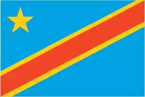
- The national symbols are leopard; national colors: sky blue, red, yellow.
- Internet TLD: .cd
The Democratic Republic of Congo, formerly known as Zaire after the river’s indigenous name, is home to five natural World Heritage sites. All of which are on the List of World Heritage in Danger due to war damage. The Virunga National Park ranges from the snow-capped Ruwenzori, at 5,000 meters above sea level, to the legendary Mountains of the Moon, through the slopes of the eponymous volcanic group inhabited by mountain gorillas and savannahs.
During Rwanda’s civil war, a million refugees settled in a refugee camp in the park, the forest was cleared, and most animals were hunted. The savannah area of Garamba National Park is the last refuge for the 30 or so remaining windswept rhinos. Kahuzi-Biega National Park is the habitat of the eastern lowland and mountain gorillas. During the civil war, refugees and military groups cleared most of the forest and wiped out three-quarters of the gorilla population. The Salonga National Park, in the ‘heart’ of the tropical rainforest, is the largest rainforest reserve in Central Africa and home to the dwarf chimpanzee and forest elephant. The Okapi Wild Reserve is home to the eponymous forest antelope in the rainforest of Ituri and is home to the Mbuti and Efe hunter-gatherer pygmy.
Background
The Kingdom of Kongo ruled the area around the mouth of the Congo River from the 14th to 19th centuries. To the center and East, the kingdoms of Luba and Lunda ruled from the 16th and 17th centuries to the 19th century. In the 1870s, European exploration of the Congo Basin, sponsored by King Leopold II of Belgium, eventually allowed the ruler to acquire rights to the Congo territory and make it his private property under the name of the Congo Free State. The king’s colonial military forced the local population to produce rubber during the Free State. From 1885 to 1908, millions of Congolese people died due to disease and exploitation. International condemnation finally forced Leopold to cede the land to Belgium, creating the Belgian Congo. The Republic of the Congo gained its independence from Belgium in 1960, but its early years were marred by political and social instability. Col. Joseph MOBUTU seized power and declared himself president in a November 1965 coup. He subsequently changed his name – to MOBUTU Sese Seko – and that of the country – to Zaire. MOBUTU retained his position for 32 years through several sham elections, as well as through brutal force. Ethnic strife and civil war, touched off by a massive inflow of refugees in 1994 from conflict in Rwanda and Burundi, led in May 1997 to the toppling of the MOBUTU regime by a rebellion backed by Rwanda and Uganda fronted by Laurent KABILA. KABILA was renamed the Democratic Republic of the Congo (DRC), but in August 1998, his regime was rechallenged by a second insurrection backed by Rwanda and Uganda.
Troops from Angola, Chad, Namibia, Sudan, and Zimbabwe supported Kabila’s regime. In January 2001, KABILA was assassinated, and his son, Joseph KABILA, was named head of state. In October 2002, the new president successfully negotiated the withdrawal of Rwandan forces occupying the eastern DRC. Two months later, the Pretoria Accord was signed by all remaining warring parties to end the fighting and establish a government of national unity. Presidential, National Assembly, and provincial legislatures took place in 2006, with Joseph KABILA elected to office. National elections were held in November 2011, and disputed results allowed Joseph KABILA to be re-elected to the presidency. While the DRC constitution barred President KABILA from running for a third term, the DRC Government delayed national elections initially slated for November 2016 to 30 December 2018. This failure to hold elections as scheduled fueled significant civil and political unrest, with sporadic street protests by Kabila’s opponents and exacerbation of tensions in the tumultuous eastern DRC regions. Presidential, legislative, and provincial elections were held in late December 2018 and early 2019 across most countries. The DRC Government canceled presidential elections in Beni and Butembo (citing concerns over an ongoing Ebola outbreak in the region) and Yumbi (which had recently experienced heavy violence). Opposition candidate Felix TSHISEKEDI was announced the election winner on 10 January 2019 and inaugurated two weeks later. This was the first transfer of power to an opposition candidate without significant violence or a coup since the DRCs independence. The DRC, particularly in the East, continues to experience violence perpetrated by more than 100 armed groups active in the region, including the Allied Democratic Forces (ADF), the Democratic Forces for the Liberation of Rwanda (FDLR), and assorted Mai Mai militias.
The UN Organization Stabilization Mission in the DRC (MONUSCO) has operated in the region since 1999 and is the most extensive and most expensive UN peacekeeping mission globally. Congo, Republic of the Upon independence in 1960, the former French region of Middle Congo became the Republic of the Congo. A quarter-century of experimentation with Marxism was abandoned in 1990, and a democratically elected government took office in 1992. A two-year civil war that ended in 1999 restored former Marxist President Denis SASSOU-Nguesso, who had ruled from 1979 to 1992, and sparked a short period of ethnic and political unrest resolved by a peace agreement in late 1999. A new constitution adopted three years later provided for a multi-party system and a seven-year presidential term, and elections arranged shortly after that installed SASSOU-Nguesso. Following a year of renewed fighting, President SASSOU-Nguesso and southern-based rebel groups agreed to a final peace accord in March 2003. SASSOU-Nguesso was re-elected in 2009 and, after passing a referendum allowing him to run for a third term, was re-elected again in 2016. The Republic of Congo is one of Africas largest petroleum producers, but with declining production, it will need new offshore oil finds to sustain its oil earnings over the long term.
Geography
The rainforested basin of the Congo River occupies 60% of the land area. High mountain ranges and lakes stretch down the eastern border.
A former Belgian colony in east-central Africa, the Democratic Republic of the Congo (DRC) is Africas second-largest country and the scene of one of its worst regional wars.
This state is located in Central Africa, northeast of Angola, under the coordinates of 0 00 N, 25 00 E, covering an area of 2,344,858 sq km with a coastline of 37 km. The Democratic Republic of the Congo is Slightly less than one-fourth the size of the US.
The Democratic Republic of the Congo has 11,027 km of land boundaries in total, and bordering with (9 nations): Angola 2646 km (of which 225 km is the boundary of Angolas discontiguous Cabinda Province), Burundi 236 km, Central African Republic 1747 km, Republic of the Congo 1775 km, Rwanda 221 km, South Sudan 714 km, Tanzania 479 km, Uganda 877 km, Zambia 2332 km.
Vast central basin is a low-lying plateau, mountains in the East, with Pic Marguerite on Mont Ngaliema (Mount Stanley) 5,110 m as the highest point of the Democratic Republic of the Congo, while Atlantic Ocean 0 m as the lowest point, causing a mean elevation at 726 m throughout the country. With a total of 2,344,858 sq km, the Democratic Republic of the Congo has 2,267,048 sq km of land and 77,810 sq km water surface area.
Major water bodies in the country: Lake Tanganyika (shared with Burundi, Tanzania, and Zambia) – 32,000 sq km; Lake Albert (shared with Uganda) – 5,590 sq km; Lake Mweru (shared with Zambia) – 4,350 sq km; Lac Mai-Ndombe – 2,300 sq km; Lake Kivu (shared with Rwanda) – 2,220 sq km; Lake Edward (shared with Uganda) – 2,150 sq km; Lac Tumba – 500 sq km; Lac Upemba – 530 sq km (freshwater lakes), Lake Manzala – 1,360 sq km (a saltwater lake) while the major rivers are: Congo river mouth (shared with Zambia, Angola, and the Republic of Congo) – 4,700 km, Ubangi river mouth (shared with the Central African Republic and the Republic of Congo) – 2,270 km. The significant watersheds for the Democratic Republic of the Congo are Atlantic Ocean drainage: Congo (3,730,881 sq km), (Mediterranean Sea), Nile (3,254,853 sq km) Indian Ocean drainage: Zambezi (1,332,412 sq km).
The second-largest country in Africa (after Algeria) and the largest country in Sub-Saharan Africa; straddles the equator; dense tropical rain forest in the central river basin and eastern highlands; the narrow strip of land that controls the lower Congo River is the DRCs only outlet to the South Atlantic Ocean.
The climate in the Democratic Republic of the Congo is as follows: Tropical, hot, and humid in the equatorial river basin, more relaxed and drier in southern highlands, cooler and wetter in eastern highlands, north of the equator – wet season (April to October), dry season (December to February), south of the equator – wet season (November to March), dry season (April to October).
When you visit the Democratic Republic of the Congo, the natural hazards shall be considered: Periodic droughts in the south; Congo River floods (seasonal); active volcanoes in the East along with the significant rift valley volcanism: Nyiragongo (3,470 m), which erupted in 2002 and is experiencing ongoing activity, poses a significant threat to the city of Goma, home to a quarter-million people; the volcano produces unusually fast-moving lava, known to travel up to 100 km/hr; Nyiragongo has been deemed a decade volcano by the international association of volcanology and chemistry of the interior of the earth, worthy of study due to its tumultuous history and proximity to human populations; its neighbor, Nyamuragira, which erupted in 2010, is Africa’s most active volcano; Visoke is the only other historically active volcano.
The following major health-threatening issues shall be considered when visiting the Democratic Republic of the Congo: degree of risk: very high (2020), bacterial and protozoal diarrhea, hepatitis A, typhoid fever, malaria, dengue fever, and trypanosomiasis-gambiense (African sleeping sickness), schistosomiasis, rabies.
Current environmental issues affecting the Congolese or Congo people: poaching threatens wildlife populations; water pollution; deforestation (forests endangered by fires set to clear the land for agricultural purposes; forests also used as a source of fuel); soil erosion; mining (diamonds, gold, coltan – a mineral used in creating capacitors for electronic devices) causing environmental damage.
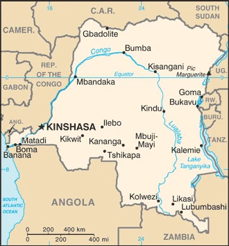
Google Maps Democratic Republic of the Congo
The capital and other divisions
Capital city: Kinshasa found under the coordinates 4 19 S, 15 18 E, applying the time zone UTC+1 (6 hours ahead of Washington, DC, during Standard Time), using the following daylight saving time: none.
Kinshasa is the capital and largest city of the Democratic Republic of Congo. It is located on the river banks of the Congo River in Central Africa, near the heart of Africa.
The Democratic Republic of the Congo became independent on 30 June 1960 (from Belgium), and its national holiday is Independence Day, 30 June (1960).
Administrative divisions: 26 provinces (provinces, singular – province); Bas-Uele (Lower Uele), Equateur, Haut-Katanga (Upper Katanga), Haut-Lomami (Upper Lomami), Haut-Uele (Upper Uele), Ituri, Kasai, Kasai-Central, Kasai-Oriental (East Kasai), Kinshasa, Kongo Central, Kwango, Kwilu, Lomami, Lualaba, Mai-Ndombe, Maniema, Mongala, Nord-Kivu (North Kivu), Nord-Ubangi (North Ubangi), Sankuru, Sud-Kivu (South Kivu), Sud-Ubangi (South Ubangi), Tanganyika, Tshopo, Tshuapa.
People and society
There are 12 main ethnic groups and around 190 smaller ones. The civil war from 1996 drew neighboring countries into a bloody conflict. The indigenous forest pygmies, victimized in the war, are now marginalized. A tentative peace deal in 2003 has been undermined by intercommunal violence in the east.
The Democratic Republic of the Congo’s population is 105,044,646 (July 2021 estimate). Note: estimates for this country explicitly take into account the effects of excess mortality due to AIDS; this can result in lower life expectancy, higher infant mortality, higher death rates, lower population growth rates, and changes in the distribution of the population by age and sex than would otherwise be expected, with an average of 3.16% (2021 estimate) change. That means the Democratic Republic of the Congo is the No. 15 in the world’s populated rank list. With an average of 16.7 years median age (16.5 years for males and 16.5 years for women), the Democratic Republic of the Congo ranks No. 222 on the globe’s median age rank list.
The people living in this country are the Congolese (also singular and plural) (noun) or Congolese or Congo (adjective) and belong mainly to the following ethnic groups: more than 200 African ethnic groups of which the majority are Bantu; the four largest tribes – Mongo, Luba, Kongo (all Bantu), and the Mangbetu-Azande (Hamitic) – make up about 45% of the population.
They speak French (official language), Lingala (a lingua franca trade language), Kingwana (a dialect of Kiswahili or Swahili), Kikongo, Tshilubamajor-language sample(s): Buku Oyo ya Bosembo ya Mokili Mobimba Ezali na Makanisi ya Liboso Mpenza. (Lingala) languages and practice the following religions: Roman Catholic 29.9%, Protestant 26.7%, other Christian 36.5%, Kimbanguist 2.8%, Muslim 1.3%, other (includes syncretic sects and indigenous beliefs) 1.2%, none 1.3%, unspecified .2% (2014 estimate).
We can conclude the following about the population in the Democratic Republic of the Congo: Urban clusters are spread throughout the country, particularly in the northeast along the border with Uganda, Rwanda, and Burundi. Kinshasha’s most significant city is located west of the congo river. The south is the least densely populated, as shown in this population distribution map. In the Democratic Republic of the Congo, we are talking about 46.2% (2021) of the total population is living in cities. Most of them reside in the following municipalities: 14.970 million, Kinshasa (capital city), 2.643 million, Mbuji-Mayi, 2.584 million, Lubumbashi, 1.524 million, Kananga, 1.321 million, Kisangani, 1.133 million, Bukavu (2021).
Industry
Rich resource base: minerals (copper, coltan, cobalt, diamonds) dominate export earnings. War and decades of corruption have caused the economic collapse. Food aid is needed to ease the humanitarian crisis.
The Democratic Republic of the Congo economy – a nation endowed with vast natural resource wealth – continues to perform poorly. Systemic corruption since independence in 1960, combined with countrywide instability and intermittent conflict that began in the early-90s, has reduced national output and government revenue and increased external debt. With the installation of a transitional government in 2003 after peace accords, economic conditions slowly improved as the government reopened relations with international financial institutions and international donors, and President KABILA began implementing reforms.
Progress on implementing substantive economic reforms remains slow because of political instability, bureaucratic inefficiency, corruption, and patronage, dampening international investment prospects. Renewed activity in the mining sector, the source of most export income, boosted Kinshasa’s fiscal position and GDP growth until 2015. Still, low commodity prices have led to slower growth, volatile inflation, currency depreciation, and a growing fiscal deficit. An uncertain legal framework, corruption, and a lack of transparency in government policy are long-term problems for the large mining sector and the economy. Much economic activity still occurs in the informal sector and is not reflected in GDP data.
Poverty remains widespread in DRC, and the country failed to meet any Millennium Development Goals by 2015. DRC also concluded its program with the IMF in 2015. The price of copper, the DRCs primary export – plummeted in 2015 and remained at record lows during 2016-17, reducing government revenues, expenditures, and foreign exchange reserves, while inflation reached nearly 50% in mid-2017 , its highest level since the early 2000s.
The Democratic Republic of the Congo is rich in the following natural resources: Cobalt, copper, niobium, tantalum, petroleum, industrial and gem diamonds, gold, silver, zinc, manganese, tin, uranium, coal, hydropower, timber.
The main industrial sectors are typically mining (copper, cobalt, gold, diamonds, coltan, zinc, tin, tungsten), mineral processing, consumer products (textiles, plastics, footwear, cigarettes), metal products, processed foods and beverages, timber, cement, commercial ship repair.
The country’s export sectors are particularly strong in copper, cobalt, crude petroleum, diamonds (2019), partnering with these nations: China 53%, United Arab Emirates 11%, Saudi Arabia 6%, South Korea 5% (2019). The export trade resulted in $13.93 billion. Note: Data are in current year dollars (2020 estimate). In a global rank of the export, values resulted in the Democratic Republic of the Congo’s position of 94.
Land use in the Democratic Republic of the Congo: 67.9% (2018 estimate) forest, 20.7% (2018 estimate) other.
The arable land area is 3.1% (2018 estimate), and the agricultural land is 11.4% (2018 estimate). Land use for permanent crops 0.3% (2018 estimate), permanent pasture 8% (2018 estimate). The sum of the area of the irrigated land is 110 sq km (2012).
The main agro-industrial products of the Democratic Republic of the Congo are cassava, plantains, sugar cane, maize, oil palm fruit, rice, roots/tubers nes, bananas, sweet potatoes, groundnuts.
The country typically needs to import: packaged medicines, refined petroleum, sulfuric acid, stone processing machines, delivery trucks (2019), partnering with the following nations: China 29%, South Africa 15%, Zambia 12%, Rwanda 5%, Belgium 5%, India 5% (2019) in a sum value of $14.56 billion. Note: data are in current year dollars (2020 estimate) $16.89 billion. Note: data are in current year dollars (2019 estimate) $17.77 billion. Note: data are in current year dollars (2018 estimate). This sum value on the global ranking list of imports resulted in the Democratic Republic of the Congo 97.
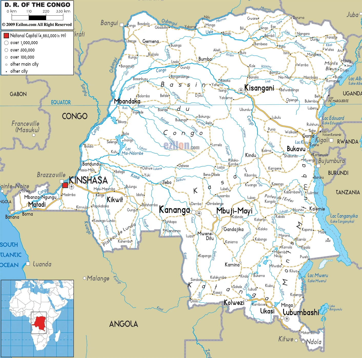
Democratic Republic of the Congo Driving Directions
In this post, you learned about the Democratic Republic of the Congo, Central Africa, northeast of Angola. We published some basic information about its capital Kinshasa, and the Congolese nation.
Are you interested in visiting the Democratic Republic of the Congo and looking for driving directions? Click here to plan your route, or see a printable road map of the Democratic Republic of the Congo below for an overview of the route network.
Printable map of Democratic Republic of the Congo
Did you know about Democratic Republic of the Congo?
The Democratic Republic of the Congo (DRC) is Central Africa, whose population is over 80% Christian. DRC has had a challenging history with violence, and one in four people were living in poverty as of 2009.
The Democratic Republic of the Congo is a country in Central Africa called Belgian Congo.
After virtually visiting the Democratic Republic of the Congo, you may also be interested in the neighboring countries: Angola, Burundi, Central African Republic, Republic of the Congo, Rwanda, South Sudan, Tanzania, Uganda, Zambia.
If you liked our Google map and Democratic the Republic of the Congo information page,
please share it with others or save the link https://www.drivingdirections.net in your bookmarks.