
Mozambique Google Maps is a site/tool that offers a wide range of map views (topographic, satellite, street view) and navigation options, with little effort on your part, yet efficiently. If you need to plan a trip to a new place like Mozambique, Google maps are available on desktop, mobile, or tablet. This Google maps and information page is dedicated to Mozambique, Africa (54 countries), showing its location, country facts, details about its capital city Maputo, bordering countries like Malawi, South Africa, Eswatini, Tanzania, Zambia, Zimbabwe, and plenty of other information which may be interesting when you visit this African state.
Quick links: Google Maps Mozambique, Maputo Google maps, Driving Directions Mozambique, Printable Road Map.
About Mozambique in a nutshell
- Maputos busy port serves Zimbabwe and South Africa.
- Conventional short form of the name: Mozambique
- The conventional long form of the name: Republic of Mozambique
- Local long form: Republica de Mocambique
- Local short form: Mocambique
- Former name(s): Portuguese East Africa, Peoples Republic of Mozambique
- Etymology: named for the offshore island of Mozambique; the island was apparently named after Mussa al-BIK, an influential Arab slave trader who set himself up as sultan on the island in the 15th century.
- The legal system in Mozambique: mixed legal system of Portuguese civil law and customary law;.
- Climate: Tropical. Temperatures are hottest on the coast. Extremes of rainfall: drought and flood.
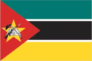
- The national symbols are national colors: green, black, yellow, white, red.
- Internet TLD: .mz
The mineral-rich country, almost nine times our size, was first landed on the shores of Europe by Vasco da Gama in 1498, but Arab traders had been trading intensively with the Bantu population for 400 years. The Portuguese also took their share of the trade, and by the 17th century, the African supply, consisting mainly of gold and ivory, had been supplemented by ‘black ivory’ enslaved people. At the end of the 19th century, two Hungarian missionaries, István Czímermann and László Menyhárth were also prominent in the exploration of Mozambique. Mozambique’s tourist attractions line the shores of the Indian Ocean: the colonial-style city of Maputo has an authentic colonial feel with its cozy restaurants, cafés, and colorful markets. The mosques of Inhambane, 400 km to the north, show the southernmost expansion of Arabism and Islam on the East African coast. The archipelago of Bazaruto, with its azure waters, craggy beaches, palm trees, and pristine coral, is a luxury holiday paradise. In contrast, the sandy beaches, fishing villages, and coral reefs of Tofo and Barra are frequented by backpackers. The country’s only world heritage site is the former Portuguese fortress city on Mozambique Island, accessible by bridge, which was the capital of Portuguese East Africa until the late 19th century.
Background
In the first half of the second millennium A.D., northern Mozambican port towns were frequented by traders from Somalia, Ethiopia, Egypt, Arabia, Persia, and India. The Portuguese were able to wrest much of the coastal trade from Arab Muslims in the centuries after 1500 and set up their colonies. Portugal did not relinquish Mozambique until 1975. Large-scale emigration, economic dependence on South Africa, a severe drought, and a prolonged civil war hindered the country’s development until the mid-1990s. The ruling Front for the Liberation of Mozambique (FRELIMO) party formally abandoned Marxism in 1989. A new constitution provided for multiparty elections and a free market economy.
An UN-negotiated peace agreement between FRELIMO and rebel Mozambique National Resistance (RENAMO) forces ended the fighting in 1992. In 2004, Mozambique underwent a delicate transition as Joaquim CHISSANO stepped down after 18 years. His elected successor, Armando GUEBUZA, served two terms and then passed executive power to Filipe NYUSI in 2015. RENAMOs residual armed forces intermittently engaged in a low-level insurgency after 2012, but a late December 2016 ceasefire eventually led to the two sides signing a comprehensive peace deal in August 2019. Elections in October 2019, challenged by Western observers and civil society as being problematic, resulted in resounding wins for NYUSI and FRELIMO across the country. Since October 2017, violent extremists – an official ISIS media outlet recognized as an ISISs network in Mozambique for the first time in June 2019 – have been conducting attacks against civilians and security services in the northern province of Cabo Delgado.
Geography
Essentially a savanna-covered plateau. Coral reefs and lagoons fringe the coast. The Zambezi River bisects the country.
Mozambique lies on the southeast African coast. It was torn apart by a savage and devastating civil war between the Marxist government and a rebel faction between 1977 and 1992.
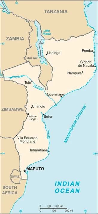
This state is located in Southeastern Africa, bordering the Mozambique Channel, between South Africa and Tanzania, under the coordinates of 18 15 S, 35 00 E, covering an area of 799,380 sq km with a coastline of 2,470 km. Mozambique is Slightly more than five times the size of Georgia; slightly less than twice the size of California.
Mozambique has 4,783 km of land boundaries and borders with (6 nations): Malawi 1498 km, South Africa 496 km, Eswatini 108 km, Tanzania 840 km, Zambia 439 km, Zimbabwe 1402 km.
Mostly coastal lowlands, uplands in the center, high plateaus in the northwest, mountains in the west, with Monte Binga 2,436 m as the highest point of Mozambique, while the Indian Ocean 0 m as the lowest point, causing a mean elevation of 345 m throughout the country. With a total of 799,380 sq km, Mozambique has 786,380 sq km of land and 13,000 sq km of water surface area.
Major water bodies in the country: Lake Malawi (shared with Malawi and Tanzania) – 22,490 (a freshwater lake), while the major rivers are: Zambezi river mouth (shared with Zambia), Angola, Namibia, Botswana, and Zimbabwe) – 2,740 km, Limpopo river mouth (shared with South Africa, Botswana, and Zimbabwe) – 1,800 km. The significant watersheds for Mozambique are Indian Ocean drainage: Zambezi (1,332,412 sq km).
The Zambezi River flows through the north-central and most fertile part of the country.
The climate in Mozambique is as follows: Tropical to subtropical.
When you visit Mozambique, the natural hazards shall be considered: Severe droughts, devastating cyclones, and floods in central and southern provinces.
The following major health-threatening issues shall be considered when visiting Mozambique: degree of risk: very high (2020), bacterial and protozoal diarrhea, hepatitis A, typhoid fever, malaria, dengue fever, schistosomiasis, rabies.
Current environmental issues affecting the Mozambican people: increased migration of the population to urban and coastal areas with adverse environmental consequences; desertification; soil erosion; deforestation; water pollution caused by artisanal mining; pollution of surface and coastal waters; wildlife preservation (elephant poaching for ivory).
Google Maps Mozambique
The capital and other divisions
Capital city: Maputo found under the coordinates 25 57 S, 32 35 E, applying the time zone UTC+2 (7 hours ahead of Washington, DC, during Standard Time), using the following daylight saving time: none.
Maputo is a city in the eastern part of Mozambique. It is one of the country’s major cities, and it is also considered one of Africa’s metropolises. Maputo has a population of 3.3 million inhabitants, of which 80% are under 40 years old. The economic growth in Maputo has been speedy, but it was mainly contributed to by tourism and industrial manufacturing.
Mozambique became independent on 25 June 1975 (from Portugal), and its national holiday is Independence Day, 25 June (1975).
Administrative divisions: 10 provinces (provincias, singular – provincia), 1 city (cidade); Cabo Delgado, Gaza, Inhambane, Manica, Maputo, Cidade de Maputo, Nampula, Niassa, Sofala, Tete, Zambezia.
People and society
Tensions exist between north and south, rather than between ethnic groups. Life is centered on the extended family. Polygamy is pretty standard. The country is struggling with the legacy of a war that killed around a million people and the effects of frequent floods and droughts. Half the population lives in abject poverty.
The population in Mozambique is 30,888,034 (July 2021 estimate). Note: estimates for this country explicitly take into account the effects of excess mortality due to AIDS; this can result in lower life expectancy, higher infant mortality, higher death rates, lower population growth rates, and changes in the distribution of the population by age and sex than would otherwise be expected, with an average of 2.58% (2021 estimate) change. That means Mozambique is the No. 46 in the world’s populated rank list. With an average of 17 years median age (16.3 years for males and 16.3 years for women), Mozambique ranks No. 219 on the globe’s median age rank list.
The people living in this country are the Mozambican(s) (noun) or Mozambican (adjective) and belong mainly to the following ethnic groups: African 99% (Makhuwa, Tsonga, Lomwe, Sena, and others), Mestizo 0.8%, other (includes European, Indian, Pakistani, Chinese) .2% (2017 estimate).
They speak Makhuwa 26.1%, Portuguese (official language) 16.6%, Tsonga 8.6%, Nyanja 8.1, Sena 7.1%, Lomwe 7.1%, Chuwabo 4.7%, Ndau 3.8%, Tswa 3.8%, other Mozambican languages 11.8%, other 0.5%, unspecified 1.8% (2017 estimate) languages and practice the following religions: Roman Catholic 27.2%, Muslim 18.9%, Zionist Christian 15.6%, Evangelical/Pentecostal 15.3%, Anglican 1.7%, other 4.8%, none 13.9%, unspecified 2.5% (2017 estimate).
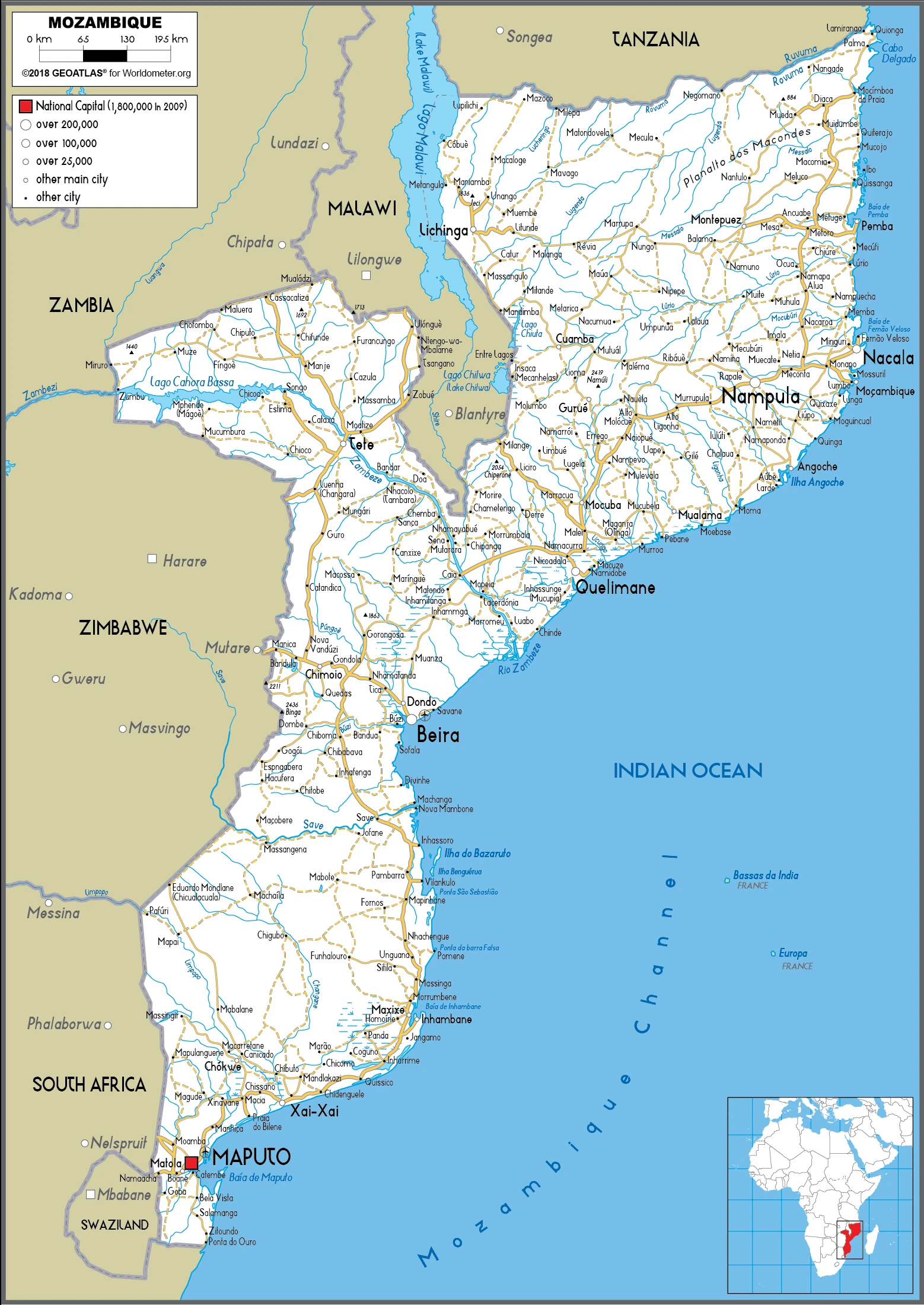
We can conclude the following about the population in Mozambique: Three large populations clusters are found along the southern coast between Maputo and Inhambane, in the central area between Beira and Chimoio along the Zambezi river, and in and around the northern cities of Nampula, Cidade de Nacala, and Pemba. The northwest and southwest are the least populated areas, as shown in this population distribution map. In Mozambique, we are talking about 37.6% (2021) of the total population lives in cities, and most of them reside in the following municipalities: 1.748 million, Matola, 1.122 million, Maputo (capital city), 887,000 Nampula (2021).
Industry
Extremely dependent on aid. Mineral potential. Cashew nuts, shrimp, cotton are exported. Debt relief.
At independence in 1975, Mozambique was one of the world’s poorest countries. Socialist policies, economic mismanagement, and a brutal civil war from 1977 to 1992 further impoverished the country. In 1987, the government embarked on a series of macroeconomic reforms designed to stabilize the economy. These steps, combined with donor assistance and political stability since the multiparty elections in 1994, propelled the country’s GDP, in purchasing power parity terms, from $4 billion in 1993 to about $37 billion in 2017. Fiscal reforms, including introducing a value-added tax and reform of the customs service, have improved the government’s revenue collection abilities. Despite these gains, about half the population remains below the poverty line, and subsistence agriculture employs the vast majority of the country’s workforce. Mozambique’s once substantial foreign debt was reduced through forgiveness and rescheduling under the IMF’s Heavily Indebted Poor Countries (HIPC) and Enhanced HIPC initiatives. However, in 2016, information surfaced revealing that the Mozambican Government was responsible for over $2 billion in government-backed loans secured between 2012-14 by the state-owned defense and security companies without parliamentary approval or national budget inclusion; this prompted the IMF and international donors to halt direct budget support to the Government of Mozambique.
An international audit was performed on Mozambique’s debt in 2016-17, but debt restructuring and resumption of donor support have yet to occur. Mozambique grew at an average annual rate of 6%-8% in the decade leading up to 2015, one of Africa’s strongest performances. Still, the sizable external debt burden, donor withdrawal, elevated inflation, and currency depreciation contributed to slower growth in 2016-2017. Two major international consortiums, led by American companies ExxonMobil and Anadarko, are seeking approval to develop massive natural gas deposits off the coast of Cabo Delgado province in what has the potential to become the largest infrastructure project in Africa. The government predicts sales of liquefied natural gas from these projects could generate several billion dollars in revenues annually sometime after 2022.
Mozambique is rich in the following natural resources: coal, titanium, natural gas, hydropower, tantalum, graphite.
The main industrial sectors are typically aluminum, petroleum products, chemicals (fertilizer, soap, paints), textiles, cement, glass, asbestos, tobacco, food, beverages.
The country’s export sectors are robust in coal, aluminum, natural gas, tobacco, electricity, gold, lumber (2019), partnering with these nations: South Africa 16%, India 13%, China 12%, Italy 7%, United Arab Emirates 5%, Germany 5% (2019). The export trade resulted in $4.35 billion. Note: Data are in current year dollars (2020 estimate). In a global rank of the export, values resulted in Mozambique’s position of 130.
Land use in Mozambique: 43.7% (2018 estimate) forest, 0% (2018 estimate) other.
The arable land area is 6.4% (2018 estimate), and the agricultural land is 56.3% (2018 estimate). Land use for permanent crops 0.3% (2018 estimate), permanent pasture 49.6% (2018 estimate). The sum of the area of the irrigated land is 1,180 sq km (2012).
The main agro-industrial products of Mozambique are sugar cane, cassava, maize, milk, bananas, tomatoes, sweet potatoes, rice, sorghum, potatoes.
The country typically needs to import: refined petroleum, chromium, iron, bauxite, electricity (2019), partnering with the following nations: South Africa 31%, India 18%, China 17% (2019) in a sum value of $8.38 billion. Note: data are in current year dollars (2020 estimate) $9.57 billion. Note: data are in current year dollars (2019 estimate) $10.52 billion. Note: data are in current year dollars (2018 estimate). This sum value on the global ranking list of imports resulted in Mozambique 116.
Mozambique Driving Directions
In this post, you learned about Mozambique, Southeastern Africa, bordering the Mozambique Channel, between South Africa and Tanzania. We published some basic information about its capital Maputo, and the Mozambican nation.
Are you interested in visiting Mozambique and looking for driving directions? Click here to plan your route, or see a printable road map of Mozambique below for an overview of the route network.
Printable map of Mozambique
Did you know about Mozambique?
Mozambique is an East African country located in the Indian Ocean. It is shaped like a triangle, and it borders Madagascar to the east, Malawi to the south, Zambia to the northwest, and Zimbabwe to the northeast. The capital city is Maputo. Mozambique has some of the most beautiful beaches in Africa that are often crowded with summer vacationers.
The Portuguese were the first Europeans to visit Mozambique. They established a trading post and plantation system on the coast of Mozambique in 1498. In 2004, Mozambique became independent from Portugal and had since been one of the fastest-growing economies in Africa.
After virtually visiting Mozambique, you may also be interested in the neighboring countries: Malawi, South Africa, Eswatini, Tanzania, Zambia, Zimbabwe.
If you liked our Google map and Mozambique information page,
please share it with others or save the link https://www.drivingdirections.net in your bookmarks.