
Angola Google Maps is a site/tool that offers a wide range of map views (topographic, satellite, street view) and navigation options, with little effort on your part, yet efficiently. If you need to plan a trip to a new place like Angola, Google maps are available on desktop, mobile, or tablet. This Google maps and information page is dedicated to Angola, Africa (54 countries), showing its location, country facts, details about its capital city, Luanda, bordering countries like the Democratic Republic of the Congo, Republic of the Congo, Namibia, Zambia, and plenty of other information which may be interesting when you visit this African state.
Quick links: Google Maps Angola, Luanda Google maps, Driving Directions Angola, Printable Road Map.
About Angola in a nutshell
- Angola has the greatest number of amputees (caused by landmines) in the world.
- Conventional short form of the name: Angola
- The conventional long form of the name: Republic of Angola
- Local long form: Republica de Angola
- Local short form: Angola
- Former name(s): Peoples Republic of Angola
- Etymology: name derived by the Portuguese from the title ngola held by kings of the Ndongo (Ndongo was a kingdom in what is now northern Angola).
- The legal system in Angola: civil legal system based on Portuguese civil law; no judicial review of legislation.
- Climate: Varies from temperate to tropical. Rainfall decreases north to south. Coast is cooler and dry.
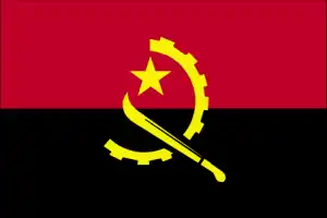
- The national symbols are Palanca Negra Gigante (giant black sable antelope); national colors: red, black, yellow.
- Internet TLD: .ao
Angola’s relatively large territory has plenty of space for a population of around 33 million. True, the colonially-rich capital Luanda, on the Atlantic coast, was built for 500 000 people at the time and is now home to many times that number: one in three Angolans live in the capital. After 27 years of civil war, the country has only been at peace since 2002. The country’s southwest is covered by the Namib desert, which was affected by the Benguela tidal current, while the north, around the Congo Delta, is now dominated by tropical rainforest. The extensive central highlands of the Biéi plateau, the savannah area, are the watershed of the Congo, the Okavango, and the Zambezi. Lubango, in the southwest, is the starting point for roads to the high coast and the 2600 m high Tunda-Vala lava mountain.
Background
From the late 14th to the mid 19th century, the Kingdom of Kongo stretched across central Africa from present-day northern Angola into the current Congo republics. It traded heavily with the Portuguese, who beginning in the 16th century, established coastal colonies and trading posts and introduced Christianity. By the 19th century, Portuguese settlement had spread to the interior. In 1914, Portugal abolished the last vestiges of the Kongo Kingdom, and Angola became a Portuguese colony.
Despite using its large oil reserves to rebuild, Angola has scored low on human development indexes since the end of a 27-year civil war in 2002. Fighting between the Popular Movement for the Liberation of Angola (MPLA), led by Jose Eduardo DOS SANTOS, and the National Union for the Total Independence of Angola (UNITA), led by Jonas SAVIMBI, followed independence from Portugal in 1975. Peace seemed imminent in 1992 when Angola held national elections, but fighting picked up again in 1993. Up to 1.5 million lives may have been lost – and 4 million people displaced – during the more than a quarter-century of fighting. Savimbi’s death in 2002 ended Unitas insurgency and cemented the MPLAs hold on power. DOS SANTOS stepped down from the presidency in 2017, having led the country since 1979. He pushed through a new constitution in 2010. Joao LOURENCO was elected president in August 2017 and became president of the MPLA in September 2018.
Geography
Most of the land is hilly and grass-covered. Desert in the south. Mountains in the center and north.
Located in southwest Africa, Angola suffered a civil war following independence from Portugal in 1975 until a 2002 peace deal. Hundreds of thousands of people died.
This state is located in Southern Africa, bordering the South Atlantic Ocean, between Namibia and the Democratic Republic of the Congo, under the coordinates of 12 30 S, 18 30 E, covering an area of 1,246,700 sq km with a coastline of 1,600 km. Angola is About eight times the size of Georgia; slightly less than twice the size of Texas.
Angola has 5,369 km of land boundaries in total, and bordering with (4 nations): the Democratic Republic of the Congo 2646 km (of which 225 km is the boundary of discontiguous Cabinda Province), Republic of the Congo 231 km, Namibia 1427 km, Zambia 1065 km.
Narrow coastal plain rises abruptly to vast interior plateau, with Moca 2,620 m as the highest point of Angola, while Atlantic Ocean 0 m as the lowest point, causing a mean elevation at 1,112 m throughout the country. With a total of 1,246,700 sq km, Angola has 1,246,700 sq km of land and 0 sq km water surface area.
The principal rivers are Zambezi (shared with Zambia s, Namibia, Botswana, Zimbabwe, and Mozambique m) – 2,740 km; Okavango river source (shared with Namibia and Botswana m) – 1,600 km. The significant watersheds for Angola are Atlantic Ocean drainage: Congo (3,730,881 sq km), Indian Ocean drainage: Zambezi (1,332,412 sq km), Internal (endorheic basin) drainage: Okavango Basin (863,866 sq km).
The province of Cabinda is an exclave, separated from the rest of the country by the Democratic Republic of the Congo.
The climate in Angola is as follows: Semiarid in the south and along the coast to Luanda, the north has a cool, dry season (May to October) and the hot, rainy season (November to April).
When you visit Angola, the natural hazards shall be considered: Locally heavy rainfall causes periodic flooding on the plateau.
The following major health-threatening issues shall be considered when visiting Angola: degree of risk: very high (2020), bacterial and protozoal diarrhea, hepatitis A, typhoid fever, dengue fever, malaria, schistosomiasis, rabies.
Current environmental issues affecting the Angolan people: overuse of pastures and subsequent soil erosion attributable to population pressures; desertification; deforestation of the tropical rain forest, in response to both international demand for tropical timber and domestic use as fuel, resulting in loss of biodiversity; soil erosion contributing to water pollution and siltation of rivers and dams; inadequate supplies of potable water.
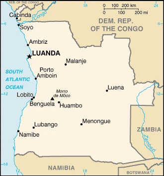
Google Maps Angola
The capital and other divisions
Capital city: Luanda found under the coordinates 40 26 W, N 79 58, applying the time zone UTC+1 (6 hours ahead of Washington, DC, during Standard Time), using the following daylight saving time: does not observe daylight savings time.
Luanda is the capital of Angola, and it is located on the south bank of the Luanda River. It has a population of about one million people. Luanda was a caravan route from the coast to Mozambique and Zambia.
Angola became independent on 11 November 1975 (from Portugal), and its national holiday is Independence Day, 11 November (1975).
Administrative divisions: 18 provinces (provincias, singular – provincia); Bengo, Benguela, Bie, Cabinda, Cuando Cubango, Cuanza-Norte, Cuanza-Sul, Cunene, Huambo, Huila, Luanda, Lunda-Norte, Lunda-Sul, Malanje, Moxico, Namibe, Uige, Zaire.
People and society
Civil war pitched the ruling Kimbundu-dominated MPLA against UNITA, representing the Ovimbundu. Multiparty elections in 19911992, after the MPLA had abandoned Marxism, failed to stall the war for long. Power-sharing from 2002 ended when the MPLA won the 2008 election. In 2006, separatists in the Cabinda exclave agreed on a peace deal.
The population in Angola is 33,642,646 (July 2021 estimate). Note: Angolas national statistical agency projected the country’s 2017 population of 28.4 million, with an average of 3.38% (2021 estimate) change. That means Angola is the No. 42 in the world’s populated rank list. With an average of 15.9 years median age (15.4 years for males and 15.4 years for women), Angola ranks No. 225 on the globe’s median age rank list.
The people living in this country are the Angolan(s) (noun) or Angolan (adjective) and belong mainly to the following ethnic groups: Ovimbundu 37%, Kimbundu 25%, Bakongo 13%, mestizo (mixed European and native African) 2%, European 1%, other 22%.
They speak Portuguese 71.2% (official language), Umbundu 23%, Kikongo 8.2%, Kimbundu 7.8%, Chokwe 6.5%, Nhaneca 3.4%, Nganguela 3.1%, Fiote 2.4%, Kwanhama 2.3%, Muhumbi 2.1%, Luvale 1%, other 3.6%; languages and practice the following religions: Roman Catholic 41.1%, Protestant 38.1%, other 8.6%, none 12.3% (2014 estimate).
We can conclude the following about the population in Angola: Most people live in the western half of the country. Urban areas account for the highest concentrations of people, particularly the capital of Luanda, as shown in this population distribution map. In Angola, we are talking about 67.5% (2021) of the total population is living in cities, and most of them reside in the following municipalities: 8.632 million, Luanda (capital city), 871,000 Lubango, 819,000 Cabinda (2021).
Industry
Potentially one of Africas wealthiest countries, but long civil war hampered economic development. Oil and diamonds are exported.
Angola’s economy is overwhelmingly driven by its oil sector. Oil production and its supporting activities contribute about 50% of GDP, more than 70% of government revenue, and more than 90% of its exports; Angola is an OPEC member and is subject to its direction regarding oil production levels. Diamonds contribute an additional 5% to exports. Subsistence agriculture provides the main livelihood for most of the people, but half of the country’s food is still imported., Increased oil production supported growth averaging more than 17% from 2004 to 2008. A postwar reconstruction boom and resettlement of displaced persons led to high growth rates in construction and agriculture. Some of the country’s infrastructures are still damaged or undeveloped from the 27-year-long civil war (1975-2002).
However, the government since 2005 has used billions of dollars in credit from China, Brazil, Portugal, Germany, Spain, and the EU to help rebuild Angola’s public infrastructure. Land mines left from the war still mar the countryside, and as a result, the national military, international partners, and private Angolan firms all continue to remove them., The global recession that started in 2008 stalled Angola’s economic growth, and many construction projects stopped because Luanda accrued billions in arrears to foreign construction companies when government revenue fell. Lower prices for oil and diamonds also decreased GDP by 0.7% in 2016. Angola formally abandoned its currency peg in 2009 but reinstituted it in April 2016 and maintains an overvalued exchange rate.
In late 2016, Angola lost the last of its correspondent relationships with foreign banks, further exacerbating challenging currency problems. Since 2013 the central bank has consistently spent down reserves to defend the kwanza, gradually allowing a 40% depreciation since late 2014. Consumer inflation declined from 325% in 2000 to less than 9% in 2014 before rising to above 30% from 2015-2017. Continued low oil prices, the depreciation of the kwanza, and slower than expected growth in non-oil GDP have reduced growth prospects. However, several major international oil companies remain in Angola. Corruption, especially in the extractive sectors, is a major long-term challenge that poses an additional threat to the economy.
Angola is rich in the following natural resources: Petroleum, diamonds, iron ore, phosphates, copper, feldspar, gold, bauxite, uranium.
The main industrial sectors are typically petroleum; diamonds, iron ore, phosphates, feldspar, bauxite, uranium, and gold; cement; basic metal products; fish processing; food processing, brewing, tobacco products, sugar; textiles; ship repair.
The country’s export sectors are particularly strong in crude petroleum, diamonds, natural gas, refined petroleum, ships (2019), partnering with these nations: China 62%, India 10%, United Arab Emirates 4%, Portugal 3%, Spain 3% (2019). The export trade resulted in $21 billion. Note: Data are in current year dollars (2020 estimate). In a global export rank, values resulted in Angola’s position of 80.
Land use in Angola: 54.3% (2018 estimate) forest.
The arable land area is 3.9% (2018 estimate), and the agricultural land is 45.7% (2018 estimate). Land use for permanent crops 0.3% (2018 estimate), permanent pasture 41.5% (2018 estimate). The sum of the area of the irrigated land is 860 sq km (2014).
The main agro-industrial products of Angola are cassava, bananas, maize, sweet potatoes, pineapples, sugar cane, potatoes, citrus fruit, vegetables, cabbage.
The country typically needs to import: refined petroleum, scrap vessels, meat, rice, palm oil (2019), partnering with the following nations: China 22%, Portugal 15%, Nigeria 6%, Belgium 6%, United States 5%, South Africa 5%, Brazil 5% (2019) in a sum value of $15.12 billion. Note: data are in current year dollars (2020 estimate) $22.3 billion. Note: data are in current year dollars (2019 estimate) $25.89 billion. Note: data are in current year dollars (2018 estimate). This sum value on the global ranking list of imports resulted in Angola 96.
Angola Driving Directions
In this post, you learned about Angola, Southern Africa, bordering the South Atlantic Ocean, between Namibia and the Democratic Republic of the Congo. We published basic information about its capital, Luanda, and the Angolan nation.
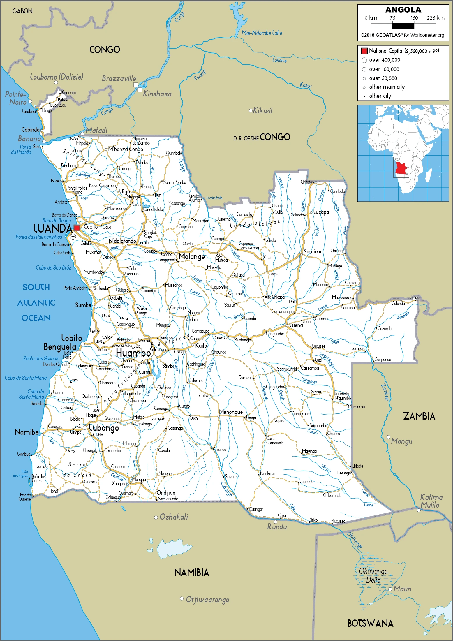
Are you interested in visiting Angola and looking for driving directions? Click here to plan your route, or see a printable road map of Angola below for an overview of the route network.
Printable map of Angola
Did you know about Angola?
Previous to the arrival of Europeans, Angola was home to a number of kingdoms and tribal states. These kingdoms traded with one another and had trading links with other parts of Africa from around 50 AD.
Did you know that relations between Angola and the United States date back to 1778? The warring parties signed the Treaty of Peace and Friendship, establishing diplomatic ties.
After virtually visiting Angola, you may also be interested in the neighboring countries: Democratic Republic of the Congo, Republic of the Congo, Namibia, Zambia.
If you liked our Google map and Angola information page,
please share it with others or save the link https://www.drivingdirections.net in your bookmarks.