
Benin Google Maps is a site/tool that offers a wide range of map views (topographic, satellite, street view) and navigation options, with little effort on your part, yet efficiently. If you need to plan a trip to a new place like Benin, Google maps are available on desktop, mobile, or tablet. This Google maps and information page is dedicated to Benin, Africa (54 countries), showing its location, country facts, details about its capital city Porto-Novo (constitutional capital); Cotonou (seat of government), bordering countries like Burkina Faso, Niger, Nigeria, Togo, and plenty of other information which may be interesting when you visit this African state.
Quick links: Google Maps Benin, Porto-Novo (constitutional capital); Cotonou (seat of government) Google maps, Driving Directions Benin, Printable Road Map.
About Benin in a nutshell
- Voodoo is thought to have originated in Benin, and was taken to Haiti by slaves.
- Conventional short form of the name: Benin
- The conventional long form of the name: Republic of Benin
- Local long form: Republique du Benin
- Local short form: Benin
- Former name(s): Dahomey, Peoples Republic of Benin
- Etymology: named for the Bight of Benin, the body of water on which the country lies.
- The legal system in Benin: civil law system modeled largely on the French system and some customary law.
- Climate: Hot and humid in the south. Two rainy seasons. Hot, dusty harmattan winds blow during the DecemberFebruary dry season.
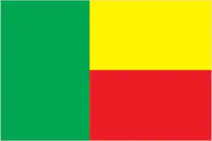
- The national symbols are leopard; national colors: green, yellow, red.
- Internet TLD: .bj
Background
Present-day Benin was the site of Dahomey, a West African kingdom that rose to prominence in about 1600. Over the next two and a half centuries, it became a regional power, primarily based on its slave trade. France began to control the coastal areas of Dahomey in the second half of the 19th century. The entire kingdom was conquered by 1894. French Dahomey achieved independence in 1960. It changed its name to the Republic of Benin in 1975. A succession of military governments ended in 1972 with the rise to power of Mathieu KEREKOU and the establishment of a government based on Marxist-Leninist principles.
A move to representative government began in 1989. Two years later, free elections ushered former Prime Minister Nicephore SOGLO as president, marking the first successful transfer of power from a dictatorship to a democracy in Africa. KEREKOU was returned to power by-elections held in 1996 and 2001, though some irregularities were alleged. KEREKOU stepped down at the end of his second term in 2006 and was succeeded by Thomas YAYI Boni, a political outsider and independent, won a second five-year term in March 2011. Patrice TALON, a wealthy businessman, took office in 2016 after campaigning to restore public confidence in the government.
Geography
Sandy coastal region. Numerous lagoons lie just behind the shoreline. Forested plateaus inland. Mountains in the northwest.
Benin stretches north from the west African coast. In 1990, Benin became one of the pioneers of African democratization, ending 17 years of one-party Marxist-Leninist rule.
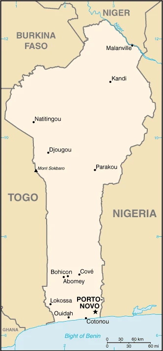
This state is located in Western Africa, bordering the Bight of Benin, between Nigeria and Togo, under the coordinates of 9 30 N, 2 15 E, covering an area of 112,622 sq km with a coastline of 121 km. Benin is Slightly smaller than Pennsylvania.
Benin has 2,123 km of land boundaries in total and borders with (4 nations): Burkina Faso 386 km, Niger 277 km, Nigeria 809 km, Togo 651 km.
Mostly flat to undulating plain, some hills and low mountains, with Mont Sokbaro 658 m as the highest point of Benin, while Atlantic Ocean 0 m as the lowest point, causing a mean elevation at 273 m throughout the country. With a total of 112,622 sq km, Benin has 110,622 sq km of land and 2,000 sq km water surface area.
The significant watersheds for Benin are Atlantic Ocean drainage: Niger (2,261,741 sq km) Volta (410,991 sq km).
sandbanks create difficult access to the coast with no natural harbors, river mouths, or islands
The climate in Benin is as follows: Tropical, hot, humid in the south, semiarid in the north.
When you visit Benin, the natural hazards shall be considered: Hot, dry, dusty harmattan wind may affect north from December to March.
The following major health-threatening issues shall be considered when visiting Benin: degree of risk: very high (2020), bacterial and protozoal diarrhea, hepatitis A, typhoid fever, dengue fever, malaria, rabies, meningococcal meningitis.
Current environmental issues affecting the Beninese people: inadequate potable water supplies; water pollution; poaching threatens wildlife populations; deforestation; desertification (the spread of the desert into agricultural lands in the north is accelerated by regular droughts).
Google Maps Benin
The capital and other divisions
Capital city: Porto-Novo (constitutional capital); Cotonou (seat of government) found under the coordinates 6 29 N, 2 37 E, applying the time zone UTC+1 (6 hours ahead of Washington, DC, during Standard Time), using the following daylight saving time: none.
Porto-Novo is the second-largest city in Benin, in the country’s southwestern region. It has a population of over 300,000 and is located in the Gulf of Guinea. In addition to its economic importance, Porto-Novo has also been home to many historical events and developments in West Africa.
Benin became independent on 1 August 1960 (from France), and its national holiday is Independence Day, 1 August (1960).
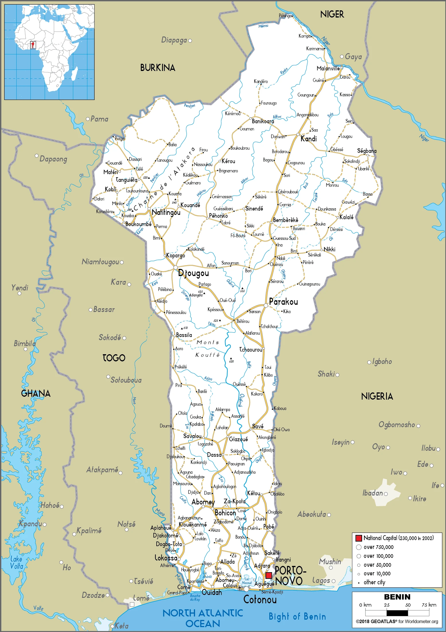
Administrative divisions: 12 departments; Alibori, Atacora, Atlantique, Borgou, Collines, Couffo, Donga, Littoral, Mono, Oueme, Plateau, Zou.
People and society
There are 42 different ethnic groups. The southern Fon has tended to dominate politics. Other significant groups are the Adja and Yoruba. The northern Fulani follow a nomadic lifestyle. North-south tension is mainly due to the south being more developed. French culture, centered on Cotonou, is highly prized. Substantial differences in wealth reflect a strongly hierarchical society.
The population in Benin is 13,301,694 (July 2021 estimate). Note: estimates for this country explicitly take into account the effects of excess mortality due to AIDS; this can result in lower life expectancy, higher infant mortality, higher death rates, lower population growth rates, and changes in the distribution of the population by age and sex than would otherwise be expected, with an average of 3.36% (2021 estimate) change. That means Benin is the No. 74 in the world’s populated rank list. With an average of 17 years median age (16.4 years for males and 16.4 years for women), Benin ranks No. 218 on the globe’s median age rank list.
The people living in this country are the Beninese (also singular and plural) (noun) or Beninese (adjective) and belong mainly to the following ethnic groups: Fon and related 38.4%, Adja and related 15.1%, Yoruba and related 12%, Bariba and related 9.6%, Fulani and related 8.6%, Ottamari and related 6.1%, Yoa-Lokpa and related 4.3%, Dendi and related 2.9%, other 0.9%, foreigner 1.9% (2013 estimate).
They speak French (official language), Fon and Yoruba (most common vernaculars in south), tribal languages (at least six major ones in north) languages and practice the following religions: Muslim 27.7%, Roman Catholic 25.5%, Protestant 13.5% (Celestial 6.7%, Methodist 3.4%, other Protestant 3.4%), Vodoun 11.6%, other Christian 9.5%, other traditional religions 2.6%, other 2.6%, none 5.8% (2013 estimate).
We can conclude the following about the population in Benin: The population is primarily located in the south, with the highest concentration of people residing in and around the cities on the Atlantic coast. As shown in this population distribution map, most of the north remains sparsely populated with higher residents in the west. In Benin, we are talking about 49% (2021) of the total population is living in cities, and most of them reside in the following municipalities: 285,000 Porto-Novo (capital city) (2018); 1.123 million, Abomey-Calavi, 699,000 Cotonou (Seat Of Government) (2021).
Industry
Strong agricultural sector: cash crops include cotton, oil palm, and cashew nuts. Large-scale smuggling is a serious problem. France is the leading aid donor. Recent floods.
The free market economy of Benin has grown consecutively for four years. However, growth slowed in 2017, as its close trade links to Nigeria exposed Benin to risks from volatile commodity prices. Cotton is an essential export commodity, with export earnings significantly impacted by the price of cotton in the broader market. The economy began deflating in 2017, with the consumer price index falling 0.8%. During the first two years of President TALONs administration, which began in April 2016, the government has followed an ambitious action plan to kickstart development through investments in infrastructure, education, agriculture, and governance. Electricity generation, which has constrained Benin’s economic growth, has increased, and blackouts have been considerably reduced. Private foreign direct investment is small, and foreign aid accounts for a large proportion of investment in infrastructure projects.
Benin has appealed for international assistance to mitigate piracy against commercial shipping in its territory and has used equipment from donors effectively against such piracy. Pilferage has significantly dropped at the Port of Cotonou, though the port is still struggling to implement the International Ship and Port Facility Security (ISPS) Code effectively. Projects included in Benin’s $307 million Millennium Challenge Corporation (MCC) first compact (2006-11) were designed to increase investment and private sector activity by improving critical institutional and physical infrastructure. The four projects focused on access to land, financial services, access to justice, and access to markets (including modernization of the port). The Port of Cotonou is a significant contributor to Benin’s economy, with revenues projected to account for more than 40% of Benin’s national budget., Benin will need further efforts to upgrade infrastructure, stem corruption, and expand access to foreign markets to achieve its potential.
In September 2015, Benin signed a second MCC Compact for $375 million that entered into force in June 2017 and is designed to strengthen the national utility service provider, attract private sector investment, fund infrastructure investments in electricity generation and distribution, and develop off-grid electrification for poor and unserved households. As part of the Government of Benin’s action plan to spur growth, Benin passed public-private partnership legislation in 2017 to attract more foreign investment, place more emphasis on tourism, facilitate the development of new food processing systems and agricultural products, encourage new information and communication technology, and establish Independent Power Producers. In April 2017, the IMF approved a three-year $150.4 million Extended Credit Facility agreement to maintain debt sustainability and boost donor confidence.
Benin is rich in the following natural resources: Small offshore oil deposits, limestone, marble, timber.
The main industrial sectors are typically textiles, food processing, construction materials, cement.
The country’s export sectors are particularly strong in cotton, refined petroleum, gold, cashews, copper (2019), partnering with these nations: Nigeria 25%, Bangladesh 14%, United Arab Emirates 14%, India 13%, China 8%, Vietnam 5% (2019). The export trade resulted in $3.58 billion. Note: Data are in current year dollars (2019 estimate). In a global rank of the export, values resulted in Benin’s position of 139.
Land use in Benin: 40% (2018 estimate) forest, 28.7% (2018 estimate) other.
The arable land area is 22.9% (2018 estimate), and the agricultural land is 31.3% (2018 estimate). Land use for permanent crops 3.5% (2018 estimate), permanent pasture 4.9% (2018 estimate). The sum of the area of the irrigated land is 230 sq km (2012).
The main agro-industrial products of Benin are cassava, yams, maize, cotton, oil palm fruit, rice, pineapples, tomatoes, vegetables, soybeans.
The country typically needs to import: rice, cars, palm oil, electricity, cotton (2019), partnering with the following nations: China 28%, Thailand 9%, India 8%, Togo 6%, United States 5% (2019) in a sum value of $4.31 billion. Note: data are in current year dollars (2019 estimate) $4.67 billion. Note: data are in current year dollars (2018 estimate) $5.035 billion (2017 estimate). This sum value on the global ranking list of imports resulted in Benin 147.
Benin Driving Directions
In this post, you learned about Benin, Western Africa, bordering the Bight of Benin, between Nigeria and Togo. We published some basic information about its capital Porto-Novo (constitutional capital), Cotonou (seat of government), and the Beninese nation.
Are you interested in visiting Benin and looking for driving directions? Click here to plan your route, or see a printable road map of Benin below for an overview of the route network.
Printable map of Benin
Did you know about Benin?
The country’s name means “land of the upright”. Benin was originally called Dahomey by the Portuguese. It has played an essential role in the African slave trade since the 16th century.
The country has one of the most stable economies in Africa, which provides an excellent environment for doing business. Benin has taken advantage of modern technologies like the Internet to move forward economically.
After virtually visiting Benin, you may also be interested in the neighboring countries: Burkina Faso, Niger, Nigeria, Togo.
If you liked our Google map and Benin information page,
please share it with others or save the link https://www.drivingdirections.net in your bookmarks.