
Comoros Google Maps is a site/tool that offers a wide range of map views (topographic, satellite, street view) and navigation options, with little effort on your part, yet efficiently. If you need to plan a trip to a new place like Comoros, Google maps are available on desktop, mobile, or tablet. This Google maps and information page is dedicated to Comoros, Africa (54 countries), showing its location, country facts, details about its capital city Moroni, bordering countries, and plenty of other information which may be interesting when you visit this African state.
Quick links: Google Maps Comoros, Moroni Google maps, Driving Directions Comoros, Printable Road Map.
About Comoros in a nutshell
- The Comoros is the worlds largest producer of ylang-ylang an extract from tree blossom used in manufacturing perfumes.
- Conventional short form of the name: DRC
- The conventional long form of the name: Democratic Republic of the Congo
- Local long form: Republique Democratique du Congo
- Local short form: RDC
- Former name(s): Congo Free State, Belgian Congo, Congo / Leopoldville, Congo / Kinshasa, Zaire
- Etymology: named for the Congo River, most of which lies within the DRC; the river name derives from Kongo, a Bantu kingdom that occupied its mouth at the time of Portuguese discovery in the late 15th century and whose name stems from its people the Bakongo, meaning hunters.
- The legal system in Comoros: mixed legal system of Islamic religious law, the French civil code of 1975, and customary law.
- Climate: Hot and humid all year round, especially on the coasts. November to May is hottest and wettest period. PEOPLE & SOCIETY
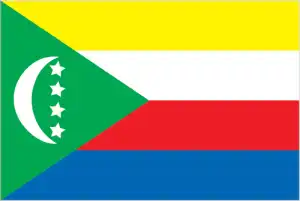
- The national symbols are four five-pointed stars and crescent moon; national colors: green, white.
- Internet TLD: .km
Background
The archipelago of Comoros in the Indian Ocean, composed of Mayotte, Anjouan, Moheli, and Grande Comore, declared independence from France on 6 July 1975. Residents of Mayotte voted to remain in France, and France now has classified it as a department of France. Since independence, Comoros has endured political instability through realized and attempted coups. In 1997, the islands of Anjouan and Moheli declared independence from Comoros. In 1999, military chief Col. AZALI Assoumani seized power of the entire government in a bloodless coup. He initiated the 2000 Fomboni Accords, a power-sharing agreement where the federal presidency rotates among the three islands and maintains its local government. AZALI won the 2002 federal presidential election as president of the Union of Comoros from Grande Comore Island, which held the first four-year term. AZALI stepped down in 2006, and President Ahmed Abdallah Mohamed SAMBI was elected to office as president from Anjouan.
In 2007, Mohamed BACAR effected Anjouan’s de-facto secession from the Union of Comoros, refusing to step down when Comoro’s other islands held legitimate elections in July. The African Union (AU) attempted to resolve the political crisis by applying sanctions and a naval blockade to Anjouan. Still, in March 2008, the AU and Comoran soldiers seized the island. The island’s inhabitants generally welcomed the move. In 2009, the Comorian population approved a constitutional referendum extending the president’s term from four years to five years. In May 2011, Ikililou DHOININE won the presidency in peaceful elections widely deemed free and fair. In closely contested elections in 2016, former President AZALI Assoumani won a second term when the rotating presidency returned to Grande Comore. A new July 2018 constitution removed the presidential term limits and the requirement for the presidency to rotate between the three main islands. In August 2018, President AZALI formed a new government and ran and was elected president in March 2019.
Geography
Main islands are of volcanic origin and are heavily forested. The remainder is coral atolls.

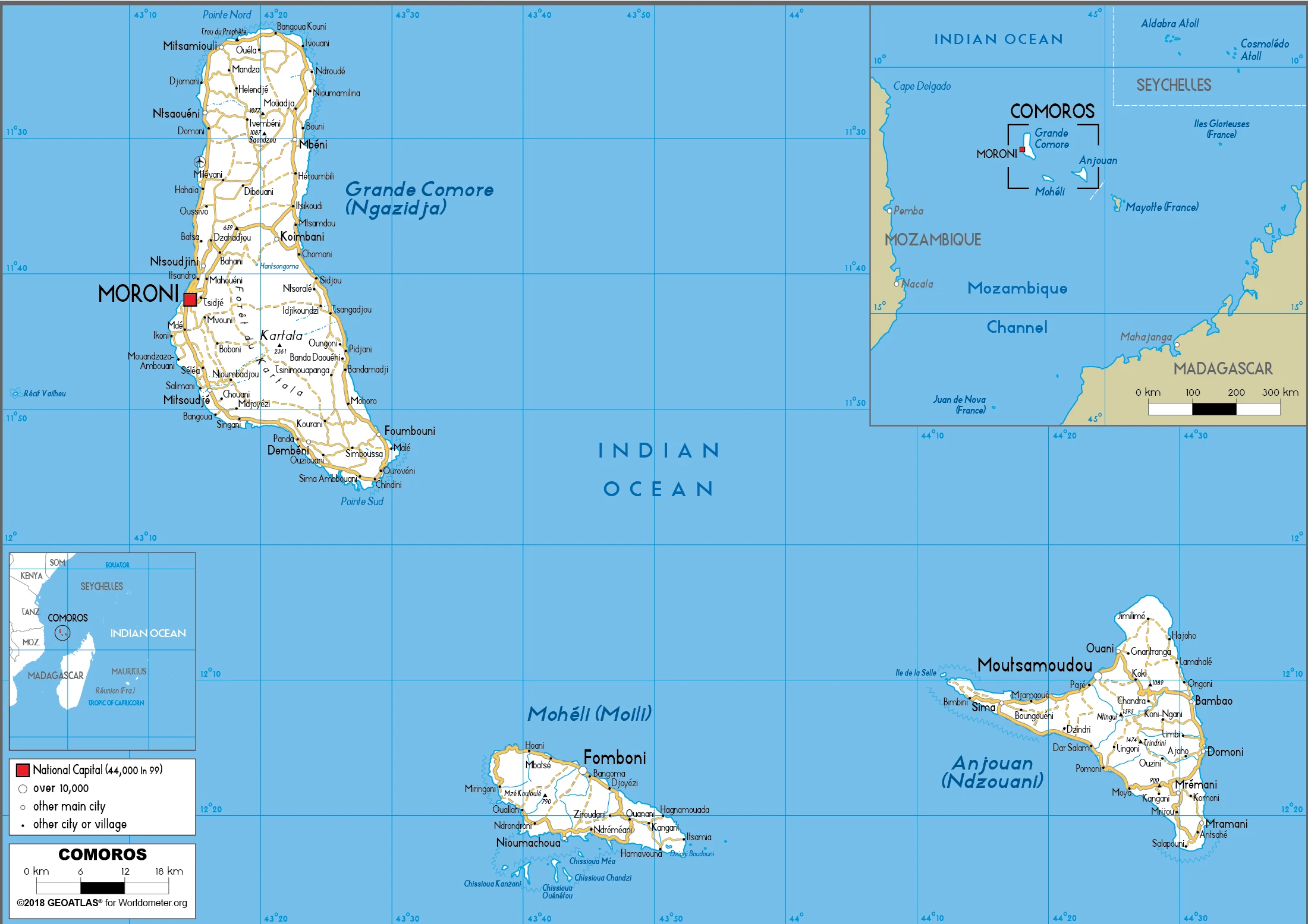
Between Mozambique and Madagascar, off the east African coast lies the archipelago Republic of Comoros, comprising three main islands and several smaller islets.
This state is located in Southern Africa, a group of islands at the northern mouth of the Mozambique Channel, about two-thirds of the way between northern Madagascar and northern Mozambique, under the coordinates of 12 10 S, 44 15 E, covering an area of 2,235 sq km with a coastline of 340 km. Comoros is Slightly more than 12 times the size of Washington, DC.
The interiors of volcanic islands vary from steep mountains to low hills, with Karthala 2,360 m as the highest point of Comoros, while the Indian Ocean 0 m as the lowest point. With a total of 2,235 sq km, Comoros has 2,235 sq km of land and 0 sq km water surface area.
Important location at the northern end of Mozambique Channel.
The climate in Comoros is as follows: Tropical marine, rainy season (November to May).
When you visit Comoros, the natural hazards shall be considered: Cyclones possible during the rainy season (December to April); volcanic activity on Grand Comore volcanism: Karthala (2,361 m) on grand Comore island last erupted in 2007; a 2005 eruption forced thousands of people to be evacuated and produced a large ash cloud.
The following major health-threatening issues shall be considered when visiting Comoros: none.
Current environmental issues affecting the Comoran people: deforestation; soil degradation and erosion resulting from forest loss and crop cultivation on slopes without proper terracing; marine biodiversity affected as soil erosion leads to the silting of coral reefs.
Google Maps Comoros
The capital and other divisions
Capital city: Moroni found under the coordinates 11 42 S, 43 14 E, applying the time zone UTC+3 (8 hours ahead of Washington, DC, during Standard Time), using the following daylight saving time: none.
The Republic of Comoros, Moroni, is a small city located in the country’s North West. King Ali Al-Salaam visited it in 1829, and it has been an important port since that time.
Comoros became independent on 6 July 1975 (from France), and its national holiday is Independence Day, 6 July (1975).
Administrative divisions: 3 islands; Anjouan (Ndzuwani), Grande Comore (Ngazidja), Moheli (Mwali).
People and society
Comoros has absorbed diverse people, including Africans, Arabs, Polynesians, and Persians. There have also been Portuguese, Dutch, French, and Indian immigrants. Ethnic discord is rare, but regional tensions between islands are marked. The country is politically unstable, and there have been frequent coups. A fragile new federal system was introduced in 2002, though in 2009, the island presidents were reduced to governors. A political and business elite controls most of the wealth.
The population in Comoros is 864,335 (July 2021 estimate), with an average of 1.41% (2021 estimate) change. That means Comoros is the No. 163 in the world’s populated rank list. With an average of 20.9 years median age (20.2 years for males and 20.2 years for women), Comoros ranks No. 188 on the globe’s median age rank list.
The people living in this country are the Comoran(s) (noun) or Comoran (adjective) and belong mainly to the following ethnic groups: Antalote, Cafre, Makoa, Oimatsaha, Sakalava.
They speak Arabic (official language), French (official language), Shikomoro (official language; a blend of Swahili and Arabic) (Comorian) languages and practice the following religions: Sunni Muslim 98%, other (including Shia Muslim, Roman Catholic, Jehovahs Witness, Protestant) 2%, note: Sunni Islam is the state religion.
We can conclude the following about the population in Comoros: The capital city of Maroni, located on the western side of the island of Grande Comore, is the country’s largest city. However, of the three islands that comprise Comoros, Anjouan is the most densely populated, as shown in this population distribution map. In Comoros, we are talking about 29.6% (2021) of the total population is living in cities, and most of them reside in the following municipalities: 62,000 Moroni (capital city) (2018).
Industry
One of the worlds poorest countries. Subsistence-level farming. Vanilla and cloves are the main cash crops. Lack of basic infrastructure.
One of the world’s poorest and smallest economies, Comoros comprises three islands hampered by inadequate transportation links, a young and rapidly increasing population, and few natural resources. The low educational level of the labor force contributes to a subsistence level of economic activity and a heavy dependence on foreign grants and technical assistance. Agriculture, including fishing, hunting, and forestry, accounts for about 50% of GDP, employs most of the labor force, and provides most exports. Export income is heavily reliant on the three main crops of vanilla, cloves, and ylang-ylang (perfume essence). Fires and extreme weather disasters easily disrupt the Comoros export earnings.
Despite agriculture’s importance to the economy, the country imports roughly 70% of its food; rice, the main staple, and other dried vegetables account for more than 25% of imports. Remittances from about 300,000 Comorans contribute about 25% of the country’s GDP. France, Comoros’s colonial power, remains a crucial trading partner and bilateral donor. Comoros faces an education system needing upgrades, limited private commercial and industrial enterprises opportunities, poor health services, limited exports, and a high population growth rate. Recurring political instability sometimes initiated from outside the country, and an ongoing electricity crisis has inhibited growth. The government, elected in mid-2016, has moved to improve revenue mobilization, reduce expenditures, and improve electricity access. However, the public sector wage bill remains one of the highest in Sub-Saharan Africa. In mid-2017, Comoros joined the Southern African Development Community with 15 other regional member states.
Comoros is rich in the following natural resources: Fish.
The main industrial sectors are typically fishing, tourism, perfume distillation.
The country’s export sectors are particularly strong in cloves, essential oils, vacuum flask, vanilla, scrap vessels (2019), partnering with these nations: France 32%, India 23%, Germany 10%, Turkey 9%, Madagascar 7% (2019). The export trade resulted in $140 million. Note: Data are in current year dollars (2019 estimate). In a global rank of the export, values resulted in Comoros’s position of 207.
Land use in Comoros: 1.4% (2018 estimate) forest, 14.2% (2018 estimate) other.
The arable land area is 46.7% (2018 estimate), and the agricultural land is 84.4% (2018 estimate). Land use for permanent crops 29.6% (2018 estimate), permanent pasture 8.1% (2018 estimate). The sum of the area of the irrigated land is 1.3 sq km (2012).
The main agro-industrial products of Comoros are coconuts, cassava, rice, bananas, pulses nes, milk, taro, sweet potatoes, maize, cloves.
The country typically needs to import: rice, chicken products, refined petroleum, cement, cars (2019), partnering with the following nations: China 22%, United Arab Emirates 16%, France 11%, Pakistan 9%, India 6% (2019) in a sum value of $350 million. Note: data are in current year dollars (2019 estimate) $360 million. Note: data are in current year dollars (2018 estimate). This sum value on the global ranking list of imports resulted in Comoros 209.
Comoros Driving Directions
In this post, you learned about Comoros, Southern Africa, a group of islands at the northern mouth of the Mozambique Channel, about two-thirds of the way between northern Madagascar and northern Mozambique. We published some basic information about its capital Moroni, and the Comoran nation.
Are you interested in visiting Comoros and looking for driving directions? Click here to plan your route, or see a printable road map of Comoros below for an overview of the route network.
Printable map of Comoros
Did you know about Comoros?
Comoros is a group of islands in the Indian Ocean off Africa’s east coast. The islands are French overseas possessions and have an official language, Comorian. Comoros was the site of one of the world’s most unusual international disputes when France faced Madagascar, claiming sovereignty over the islands.
After virtually visiting Comoros, you may also be interested in the neighboring countries: none.
If you liked our Google map and Comoros information page,
please share it with others or save the link https://www.drivingdirections.net in your bookmarks.