
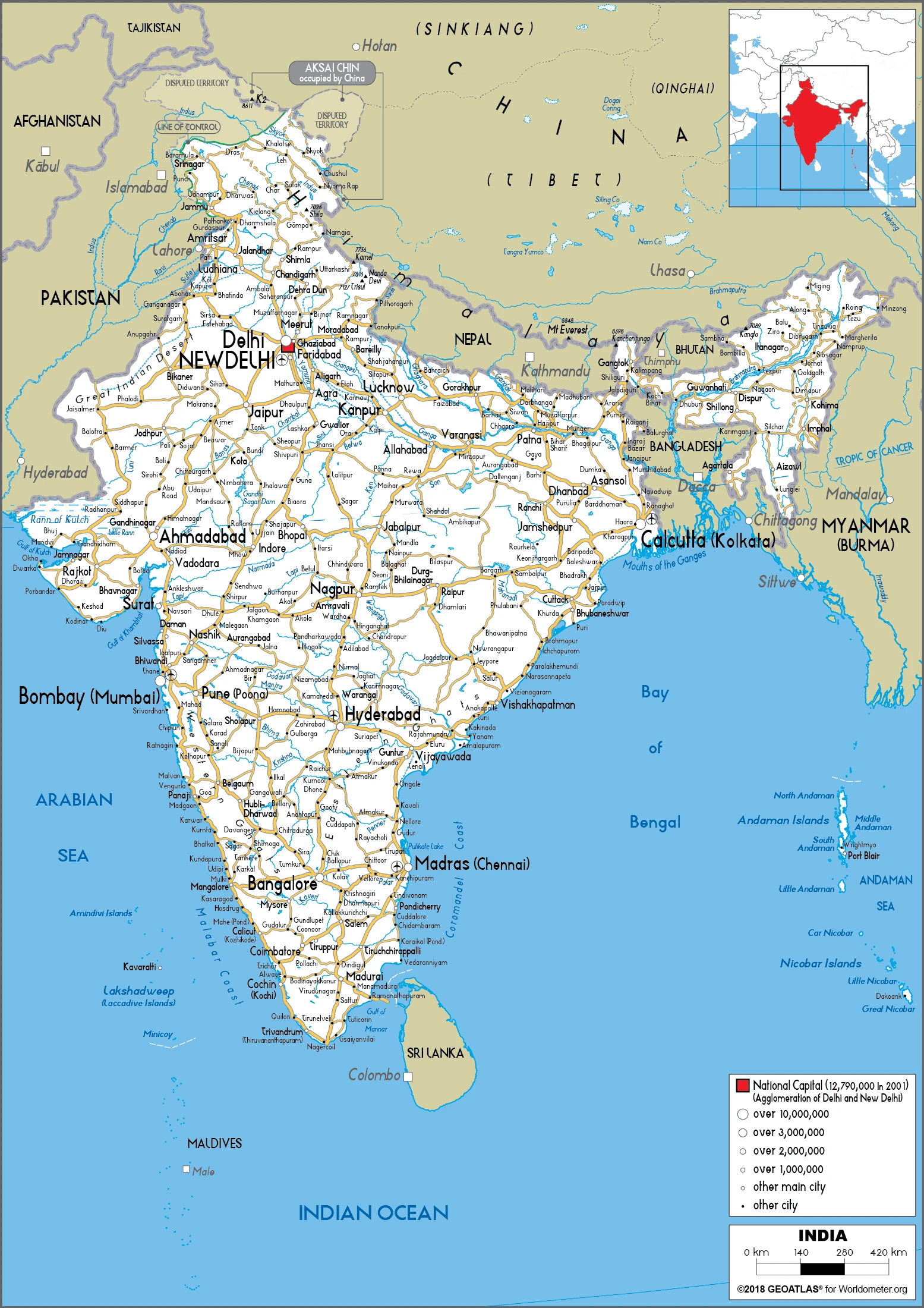
India Google Maps is a site/tool that offers a wide range of map views (topographic, satellite, street view) and navigation options, with little effort on your part, yet efficiently. If you need to plan a trip to a new place like India, Google maps are available on desktop, mobile, or tablet. This Google maps and information page is dedicated to India, Asia (22 countries), showing its location, country facts, details about its capital city New Delhi, bordering countries like Bangladesh, Bhutan, Burma, China, Nepal, Pakistan, and plenty of other information which may be interesting when you visit this Asian state.
Quick links: Google Maps India, New Delhi Google maps, Driving Directions India, Printable Road Map.
About India in a nutshell
- Indias national animal, the tiger, was depicted as early as 4000 years ago by the Mohenjo-Daro civilization.
- Conventional short form of the name: India
- The conventional long form of the name: Republic of India
- Local long form: Republic of India / Bharatiya Ganarajya
- Local short form: India / Bharat
- Etymology: named for the country of India, which makes up much of its northern border.
- The legal system in India: common law system based on the English model; separate personal law codes apply to Muslims, Christians, and Hindus; judicial review of legislative acts;.
- Climate: Varies greatly according to latitude, altitude, and season. Most of India has three seasons: hot, wet, and cool. Summer temperatures in the north can reach 104°F (40°C). Monsoon rains normally break in June, petering out in September to October. In the cool season, the weather is mainly dry. The in the warmer south is less variable than in the north.
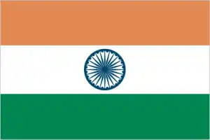
- The national symbols are the Lion Capital of Ashoka, which depicts four Asiatic lions standing back to back mounted on a circular abacus, is the official emblem; Bengal tiger; lotus flower; national colors: saffron, white, green.
- Internet TLD: .in
Once dubbed ‘the jewel in the crown of Britain’, the subcontinent of a billion people – exactly one-third of Europe – has been imbued with the charms, splendor, scents, and colors of Asia, the fabulous East, ancient traditions and customs, the teachings of two world religions and numerous sects, the achievements of colonial and modern times. North and South, East and West Indies – each a world apart. Its 27 World Heritage sites include five natural heritages, including almost every habitat in Asia from the Himalayas in India, well over 7,000m, to the Sundarbans mangrove swamps of the Ganges Delta: the last wild sanctuaries of the Indian rhinoceros, the Bengal tiger, and the Indian elephant. World Heritage Sites include Hindu and Buddhist cave shrines, temples and temple towns, fortresses, palaces and cities of rulers and maharajas, and opulent tombs.
Background
The Indus Valley civilization, one of the world’s oldest, flourished during the 3rd and 2nd millennia B.C. and extended into northwestern India. Aryan tribes from the northwest infiltrated the Indian subcontinent about 1500 B.C. Their merger with the earlier Dravidian inhabitants created the classical Indian culture. The Maurya Empire of the 4th and 3rd centuries B.C. – which reached its zenith under ASHOKA – united much of South Asia. The Golden Age ushered in by the Gupta dynasty (4th to 6th centuries A.D.) saw Indian science, art, and culture flowering. Islam spread across the subcontinent for over 700 years. In the 10th and 11th centuries, Turks and Afghans invaded India and established the Delhi Sultanate. In the early 16th century, Emperor BABUR established the Mughal Dynasty, which ruled India for more than three centuries. European explorers began establishing footholds in India during the 16th century. By the 19th century, Great Britain had become the dominant political power on the subcontinent, and India was seen as the Jewel in the Crown of the British Empire.
The British Indian Army played a vital role in both World Wars. Years of nonviolent resistance to British rule, led by Mohandas GANDHI and Jawaharlal NEHRU, eventually resulted in Indian independence in 1947. Large-scale communal violence occurred before and after the subcontinent partition into two separate states – India and Pakistan. The neighboring countries have fought three wars since independence, the last of which was in 1971, resulting in East Pakistan becoming the separate nation of Bangladesh. India’s nuclear weapons tests in 1998 emboldened Pakistan to conduct its tests that same year.
In November 2008, terrorists from Pakistan conducted a series of coordinated attacks in Mumbai, India’s financial capital. India’s economic growth following the launch of economic reforms in 1991, a massive youthful population, and a strategic geographic location have contributed to India’s emergence as a regional and global power. However, India still faces pressing problems such as environmental degradation, extensive poverty, and widespread corruption, and its restrictive business climate is dampening economic growth expectations.
Geography
India forms a subcontinent separated from northern Asia by the Himalaya mountain range. As well as the Himalayas, there are two other central geographical regions, the Indo-Gangetic Plain, which lies between the foothills of the Himalayas and the Vindhya Mountains central-southern Deccan plateau. The Ghats are smaller mountain ranges located on the East and West coasts.

India is the worlds second-most populous country and largest democracy. Despite some success in reducing the birth rate, its population will probably overtake China by 2028.
This state is located in Southern Asia, bordering the Arabian Sea and the Bay of Bengal, between Burma and Pakistan, under the coordinates of 20 00 N, 77 00 E, covering an area of 70.560 million sq km with a coastline of 7,000 km. India is Slightly more than one-third the size of the U.S.
India has 13,888 km of land boundaries in total, and bordering with (6 nations): Bangladesh 4142 km, Bhutan 659 km, Burma 1468 km, China 2659 km, Nepal 1770 km, Pakistan 3190 km.
Upland plain (Deccan Plateau) in the South, flat to rolling plain along the Ganges, deserts in west, the Himalayas in the north, with Kanchenjunga 8,586 m as the highest point of India, while Indian Ocean 0 m as the lowest point, causing a mean elevation at 160 m throughout the country. With 70.560 million sq km, India has 2,973,193 sq km of land and 314,070 sq km water surface area.
Major water bodies in the country: Chilika Lake – 1,170 sq km (saltwater lake) while the major rivers are: Brahmaputra (shared with China and Bangladesh) – 3,969 km, Indus (shared with China and Pakistan) – 3,610 km, Ganges river source (shared with Bangladesh) – 2,704 km, Godavari – 1,465 km, Sutlej (shared with China and Pakistan) – 1,372 km, Yamuna – 1,370 km, Narmada – 1,289 km, Chenab river source (shared with Pakistan) – 1,086 km, Ghaghara river mouth (shared with China s and Nepal) – 1,080 km. The significant watersheds for India are Indian Ocean drainage: Brahmaputra (651,335 sq km), Ganges (1,016,124 sq km), Indus (1,081,718 sq km), Irrawaddy (413,710 sq km).
Dominates South Asian subcontinent; near important Indian Ocean trade routes; Kanchenjunga, the third tallest mountain in the world, lies on the border with Nepal.
The climate in India is as follows: Varies from tropical monsoon in South to temperate in north.
When you visit India, the natural hazards shall be considered: Droughts; flash floods, widespread and destructive flooding from monsoonal rains; severe thunderstorms; earthquakes, volcanism: barren island (354 m) in the Andaman sea has been active in recent years.
The following major health-threatening issues shall be considered when visiting India: degree of risk: very high (2020), bacterial diarrhea, hepatitis A and E, and typhoid fever, dengue fever, Crimean-Congo hemorrhagic fever, Japanese encephalitis, malaria, leptospirosis, rabies.
Current environmental issues affecting the Indian people: deforestation; soil erosion; overgrazing; desertification; air pollution from industrial effluents and vehicle emissions; water pollution from raw sewage and runoff of agricultural pesticides; tap water is not potable throughout the country; huge and growing population is overstraining natural resources; preservation and quality of forests; biodiversity loss.
Google Maps India
The capital and other divisions
Capital city: New Delhi found under the coordinates 28 36 N, 77 12 E, applying the time zone UTC+5.5 (10.5 hours ahead of Washington, DC, during Standard Time), using the following daylight saving time: none.
New Delhi is the capital of India and the largest city of Indias most populous state, Uttar Pradesh. New Delhi is also the foremost diplomatic center of India, home to many embassies and consulates that attract residents worldwide.
India became independent on 15 August 1947 (from the U.K.), and its national holiday is Republic Day, 26 January (1950).
Administrative divisions: 28 states and 8 union territories; Andaman and Nicobar Islands, Andhra Pradesh, Arunachal Pradesh, Assam, Bihar, Chandigarh, Chhattisgarh, Dadra and Nagar Haveli and Daman and Diu, Delhi, Goa, Gujarat, Haryana, Himachal Pradesh, Jammu and Kashmir, Jharkhand, Karnataka, Kerala, Ladakh, Lakshadweep, Madhya Pradesh, Maharashtra, Manipur, Meghalaya, Mizoram, Nagaland, Odisha, Puducherry, Punjab, Rajasthan, Sikkim, Tamil Nadu, Telangana, Tripura, Uttar Pradesh, Uttarakhand, West Bengal note: although its status is that of a union territory, the official name of Delhi is National Capital Territory of Delhi.
People and society
Indias planners, overseeing an economic revolution, see its growing population rather than environmental constraints as the main brake on development. Nationwide awareness campaigns promote birth control, but cultural and religious pressures encourage large families. Rural deprivation spurs urban migration to live in sprawling slums. Over 70% of people survive on less than $2 a day. The majority of Indians are Hindu. Various attempts to reform the Hindu caste system, which determines social standing and even marriage, have met violent opposition. Severe tensions exist between Hindus and the Muslim minority, especially in Kashmir and Gujarat. Smaller ethnic groups exist in the northeast, and many struggles for greater autonomy. Over two million people are living with HIV/AIDS.
The population in India is 1,339,330,514 (July 2021 estimate), with an average of 1.04% (2021 estimate) change. That means India is the No. 2 in the world’s populated rank list. With an average of 28.7 years median age (28 years for males and 28 years for women), India ranks No. 141 on the globe’s median age rank list.
The people living in this country are the Indian(s) (noun) or Indian (adjective) and belong mainly to the following ethnic groups: Indo-Aryan 72%, Dravidian 25%, Mongoloid, and other 3% (2000).
They speak Hindi 43.6%, Bengali 8%, Marathi 6.9%, Telugu 6.7%, Tamil 5.7%, Gujarati 4.6%, Urdu 4.2%, Kannada 3.6%, Odia 3.1%, Malayalam 2.9%, Punjabi 2.7%, Assamese 1.3%, Maithili 1.1%, other 5.6%; languages and practice the following religions: Hindu 79.8%, Muslim 14.2%, Christian 2.3%, Sikh 1.7%, other and unspecified 2% (2011 estimate).
We can conclude the following about the population in India: With the notable exception of the deserts in the northwest, including the Thar desert, and the mountain fringe in the north, a very high population density exists throughout most of the country. The core of the population is in the north along the banks of the Ganges, with other river valleys and southern coastal areas also having large population concentrations. In India, we are talking about 35.4% (2021) of the total population is living in cities. Most of them reside in the following municipalities: 31.181 million, New Delhi (capital city), 20.668 million, Mumbai, 14.974 million, Kolkata, 12.765 million, Bangalore, 11.235 million, Chennai, 10.269 million, Hyderabad (2021).
Industry
One of the worlds fastest-growing economies. Protectionism has given way to free-market economics. Tea, gems, textiles exported. High-tech industries, outsourcing center. The success of “Bollywood” films. Cheap labor. Huge market, held back by poverty.
India’s diverse economy encompasses traditional village farming, modern agriculture, handicrafts, a wide range of modern industries, and many services. Slightly less than half of the workforce is in agriculture. Still, services are the primary source of economic growth, accounting for nearly two-thirds of India’s output but employing less than one-third of its labor force. India has capitalized on its large educated English-speaking population to become a major exporter of information technology services, business outsourcing services, and software workers. Nevertheless, per capita income remains below the world average. India is developing into an open-market economy, yet its past autarkic policies remain. Economic liberalization measures, including industrial deregulation, privatization of state-owned enterprises, and reduced controls on foreign trade and investment, began in the early 1990s and accelerated the country’s growth, averaging nearly 7% per year from 1997 to 2017. India’s economic growth slowed in 2011 because of a decline in investment caused by high-interest rates, rising inflation, and investor pessimism about the government’s commitment to further economic reforms and slow world growth. Investors’ perceptions of India improved in early 2014 due to a reduction of the current account deficit and expectations of post-election economic reform, resulting in a surge of inbound capital flows and stabilization of the rupee. Growth rebounded in 2014 through 2016.
Despite a high growth rate compared to the rest of the world, Indian government-owned banks faced mounting bad debt, resulting in low credit growth. Rising macroeconomic imbalances in India and improving economic conditions in Western countries led investors to shift capital away from India, prompting a sharp depreciation of the rupee through 2016., The economy slowed again in 2017 due to shocks of demonetization in 2016 and the introduction of GST in 2017. Since the election, the government has passed an essential goods and services tax bill and raised foreign direct investment caps in some sectors. Still, most economic reforms have focused on administrative and governance changes, mainly because the ruling party remains a minority in India’s upper house of Parliament, which must approve most bills. India has a young population and corresponding low dependency ratio, healthy savings and investment rates, and its increasing integration into the global economy. However, long-term challenges remain significant, including Indias discrimination against women and girls, an inefficient power generation and distribution system, ineffective enforcement of intellectual property rights, decades-long civil litigation dockets, inadequate transport and agricultural infrastructure, limited non-agricultural employment opportunities, high spending, and poorly targeted subsidies, inadequate availability of quality primary and higher education, and accommodating rural-to-urban migration.
India is rich in the following natural resources: Coal (fourth-largest reserves in the world), antimony, iron ore, lead, manganese, mica, bauxite, rare earth elements, titanium ore, chromite, natural gas, diamonds, petroleum, limestone, arable land.
The main industrial sectors are textiles, chemicals, food processing, steel, transportation equipment, cement, mining, petroleum, machinery, software, pharmaceuticals.
The country’s export sectors are robust in refined petroleum, diamonds, packaged medicines, jewelry, cars (2019), partnering with these nations: the United States 17%, United Arab Emirates 9%, China 5% (2019). The export trade resulted in $484.95 billion. Note: Data are in current year dollars (2020 estimate). In a global rank of the export, values resulted in India’s position of 13.
Land use in India: 23.1% (2018 estimate) forest, 16.4% (2018 estimate) other.
The arable land area is 52.8% (2018 estimate), and the agricultural land is 60.5% (2018 estimate). Land use for permanent crops 4.2% (2018 estimate), permanent pasture 3.5% (2018 estimate). The sum of the area of the irrigated land is 667,000 sq km (2012).
The main agro-industrial products of India are sugar cane, rice, wheat, buffalo milk, milk, potatoes, vegetables, bananas, maize, mangoes/guavas.
The country typically needs to import: crude petroleum, gold, coal, diamonds, natural gas (2019), partnering with the following nations: China 15%, United States 7%, United Arab Emirates 6%, Saudi Arabia 5% (2019) in a sum value of $493.18 billion. Note: data are in current year dollars (2020 estimate) $619.48 billion. Note: data are in current year dollars (2019 estimate) $642.96 billion. Note: data are in current year dollars (2018 estimate). This sum value on the global ranking list of imports resulted in India 11.
India Driving Directions
In this post, you learned about India, Southern Asia, bordering the Arabian Sea and the Bay of Bengal, between Burma and Pakistan. We published some basic information about its capital New Delhi, and the Indian nation.
Are you interested in visiting India and looking for driving directions? Click here to plan your route, or see a printable road map of India below to overview the route network.
Printable map of India
Did you know about India?
India is a land of diversity, and people from all over the world have come to these old lands. India is known for its ancient history, magnificent architecture, and beautiful culture. India is also a country that relies heavily on agriculture as its primary form of income, and they are one of the largest producers of rice in the world.
After virtually visiting India, you may also be interested in the neighboring countries: Bangladesh, Bhutan, Burma, China, Nepal, Pakistan.
If you liked our Google map and India information page,
please share it with others or save the link https://www.drivingdirections.net in your bookmarks.