
Marshall Islands Google Maps is a site/tool that offers a wide range of map views (topographic, satellite, street view) and navigation options, with little effort on your part, yet efficiently. If you need to plan a trip to a new place like the Marshall Islands, Google maps are available on desktop, mobile, or tablet. This Google maps and information page is dedicated to the Marshall Islands, Oceania (27 countries), showing its location, country facts, details about its capital city Majuro, and plenty of other information which may be interesting when you visit this Oceanian state.
Quick links: Google Maps Marshall Islands, Majuro Google maps, Driving Directions Marshall Islands, Printable Road Map.

About Marshall Islands in a nutshell
- Conventional short form of the name: Marshall Islands
- The conventional long form of the name: Republic of the Marshall Islands
- Local long form: Republic of the Marshall Islands
- Local short form: Marshall Islands
- Former name(s): Trust Territory of the Pacific Islands, Marshall Islands District
- Etymology: named after British Captain John MARSHALL, who charted many of the islands in 1788.
- The legal system in Marshall Islands: mixed legal system of US and English common law, customary law, and local statutes.
- Climate: Tropical oceanic, cooled year round by northeast trade winds.
- The national symbols are a 24-rayed star; national colors: blue, white, orange.
- Internet TLD: .mh
In 1954, Bikini Atoll was the site for testing the largest U.S. H-bomb, the 1822 megatons Bravo.
Radioactivity contaminated site
At first glance, Bikini Atoll in the Pacific Ocean looks like a picture-book tropical paradise, but a closer look reveals a very different story.
With 23 islands, the atoll is a veritable ghost town. Between 1946 and 1958, the U.S. carried out 67 nuclear weapons tests in the Marshall Islands, including Bikini Atoll. Although Bikini is still a closed area, the traces of the destruction have almost disappeared, and nature has recovered somewhat, the long-term consequences of the experiments have not gone away without a trace. The greatest danger lies in the cesium-contaminated soil: plants and crops are still contaminated, and the risk of radiation exposure is extremely high if consumed continuously. Therefore, the 4,500 Bikini inhabitants live on the surrounding islands of Majuro, Mejit, and Kili. Most of the food – mainly canned food – is imported because the nuclear cloud once reached this region. Worse still, hundreds of islanders have fallen ill and died of cancer because of the experiments.
Nevertheless, the atoll was declared habitable as early as 1968, following a significant clean-up operation. But when researchers measured levels of radioactivity in marine plants and animals, drinking water, and crops that were higher than acceptable levels a short time later, Bikini’s inhabitants were forced to leave their homes again. In the late 1990s, the living conditions were declared “unhealthy”. Bikini is still a deserted island, except for a small diving base where shipwrecks are searched. According to some experts, it will be another 30 years before the inhabitants of Bikini can truly return to their former home. The atoll was declared a World Heritage site by UNESCO in 2010 as a “symbol of the nuclear age”.
Background
Humans arrived in the Marshall Islands in the first millennium B.C. and gradually created permanent settlements on the various atolls. The early inhabitants were skilled navigators who frequently traveled between atolls using stick charts to map the islands. Society became organized under two paramount chiefs, each for the Ratak (Sunrise) Chain and the Ralik (Sunset) Chain. The traditional hierarchy continued even after contact with Europeans in the early 1500s. Spain formally claimed the islands in 1592, but few other Europeans passed by the islands in the next two centuries. In 1788, British sea captain John MARSHALL undertook an exploratory voyage, and the islands were mapped in the early 1800s by Russian explorers. In the 1850s, U.S. Protestant missionaries began arriving on the islands. Germany established a supply station on Jaluit Atoll and bought the islands from Spain in 1884, although paramount chiefs continued to rule. Japan seized the Marshall Islands in 1914 and was granted a League of Nations Mandate to administer the islands in 1920. Japan built large military bases throughout the Marshall Islands, and during World War II, the U.S. captured the bases on Kwajalein, Enewetak, and Majuro Atolls in Operations Flintlock and Catchpole. The Marshall Islands came under U.S. administration as part of the Trust Territory of the Pacific Islands (TTPI) in 1947.
Between 1946 and 1958, the U.S. resettled populations from Bikini and Enewetak Atolls and conducted 67 nuclear tests. People from Ailinginae and Rongelap Atolls were evacuated because of nuclear fallout, and all four atolls remain primarily uninhabited. In 1979, the Marshall Islands drafted a constitution separate from the rest of the TTPI and declared independence under President Amata KABUA, a paramount chief. In 2000, Kessai NOTE became the first commoner elected president. In 2016, Hilda HEINE was the first woman elected president. In 1982, the Marshall Islands signed a Compact of Free Association (COFA) with the U.S., which granted the Marshall Islands financial assistance and access to many U.S. domestic programs in exchange for exclusive U.S. military access and defense responsibilities. The COFA entered into force in 1986, and its funding was renewed in 2003. The Marshall Islands hosts the U.S. Army Kwajalein Atoll Reagan Missile Test Site, an essential installation in the U.S. missile defense network. Kwajalein also hosts one of four dedicated ground antennas that assist in the operation of the Global Positioning System (GPS) navigation system (the others are at Cape Canaveral, Florida (U.S.), on Ascension (Saint Helena, Ascension, and Tristan da Cunha), and at Diego Garcia (British Indian Ocean Territory)).
Geography
Narrow coral rings with sandy beaches enclosing lagoons. Those in the south have thicker vegetation. Kwajalein is the worlds largest atoll.
Under U.S. rule as part of the U.N. Trust Territory of the Pacific Islands until independence in 1986, the Marshall Islands comprises a group of 34 widely scattered atolls.
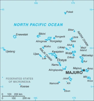
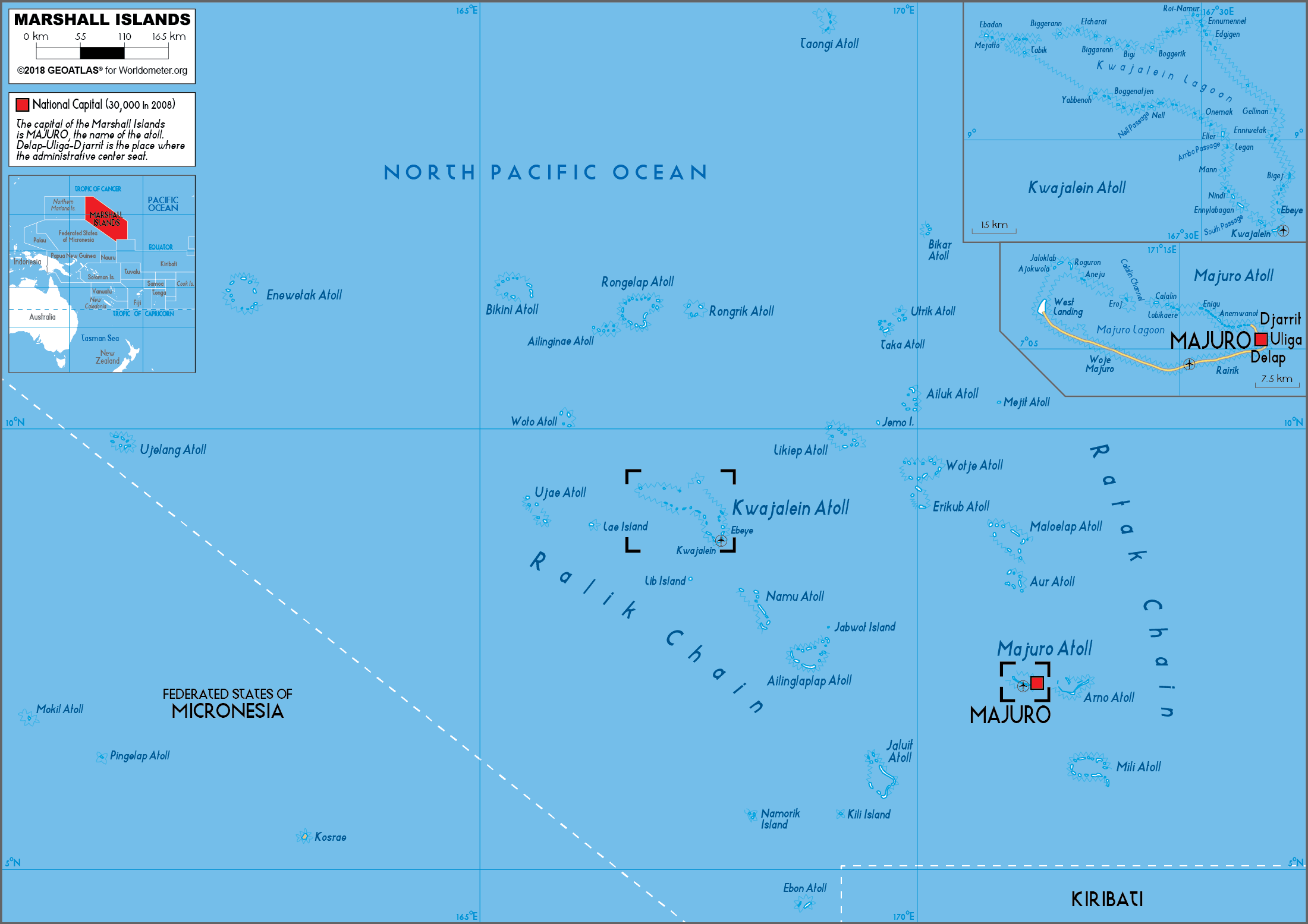
This state is located in Oceania and consists of 29 atolls and five isolated islands in the North Pacific Ocean, about halfway between Hawaii and Australia. The atolls and islands are situated in two almost-parallel island chains – the Ratak (Sunrise) group and the Ralik (Sunset) group. The total number of islands and islets is about 1,225. Twenty-two of the atolls and four of the islands are uninhabited, under the coordinates of 9 00 N, 168 00 E, covering an area of 181 sq km with a coastline of 370.4 km. Marshall Islands is About the size of Washington, DC.
Low coral limestone and sand islands, with East-central Airik Island, Maloelap atoll 14 m as the highest point of Marshall Islands, while Pacific Ocean 0 m as the lowest point, causing a mean elevation at 2 m throughout the country. With a total of 181 sq km, the Marshall Islands has 181 sq km of land and 0 sq km of water surface area.
The islands of Bikini and Enewetak are former U.S. nuclear test sites; Kwajalein atoll, famous as a World War II battleground, surrounds the world’s largest lagoon and is used as a U.S. missile test range; the island city of Ebeye is the second-largest settlement in the Marshall Islands, after the capital of Majuro, and one of the most densely populated locations in the Pacific.
The climate in the Marshall Islands is as follows: Tropical, hot and humid. During the wet season, May to November, islands border the typhoon belt.
When you visit the Marshall Islands, the natural hazards shall be considered: Infrequent typhoons.
The following major health-threatening issues shall be considered when visiting the Marshall Islands: degree of risk: high (2020), bacterial diarrhea, malaria.
Current environmental issues affecting the Marshallese people: inadequate supplies of potable water; pollution of Majuro lagoon from household waste and discharges from fishing vessels; sea-level rise.
Google Maps Marshall Islands
The capital and other divisions
Capital city: Majuro found under the coordinates 7 06 N, 171 23 E, applying the time zone UTC+12 (17 hours ahead of Washington, DC, during Standard Time), using the following daylight saving time: none.
Majuro is the capital of the Marshall Islands, an independent republic in free association with New Zealand. Its economy is based on fishing, subsistence agriculture, and tourism. The primary employer in Majuro is the government.
Marshall Islands became independent on 21 October 1986 (from the US-administered UN trusteeship), and its national holiday is Constitution Day, 1 May (1979).
Administrative divisions: 24 municipalities; Ailinglaplap, Ailuk, Arno, Aur, Bikini & Kili, Ebon, Enewetak & Ujelang, Jabat, Jaluit, Kwajalein, Lae, Lib, Likiep, Majuro, Maloelap, Mejit, Mili, Namorik, Namu, Rongelap, Ujae, Utrik, Wotho, Wotje.
People and society
Over half the population lives in Majuro, the capital and commercial center. Life on the outlying islands is still traditional, based on subsistence agriculture and fishing. Tensions are high due to poor living conditions, especially in periods of drought or flooding. Society is matrilineal, with land and titles handed down through the mothers clan.
The population in the Marshall Islands is 78,831 (July 2021 estimate), with an average of 1.37% (2021 estimate) change. That means the Marshall Islands is the No. 200 in the world’s populated rank list. With an average of 23.8 years median age (23.6 years for males and 23.6 years for women), the Marshall Islands ranks No. 173 on the globe’s median age rank list.
The people living in this country are the Marshallese (also singular and plural) (noun) or Marshallese (adjective) and belong mainly to the following ethnic groups: Marshallese 92.1%, mixed Marshallese 5.9%, other 2% (2006 estimate).
They speak Marshallese (official language) 98.2%, other languages 1.8% (1999 estimate) languages and practice the following religions: Protestant 80.5% (United Church of Christ 47%, Assembly of God 16.2%, Bukot Nan Jesus 5.4%, Full Gospel 3.3%, Reformed Congressional Church 3%, Salvation Army 1.9%, Seventh Day Adventist 1.4%, Meram in Jesus 1.2%, other Protestant 1.1%), Roman Catholic 8.5%, Church of Jesus Christ 7%, Jehovahs Witness 1.7%, other 1.2%, none 1.1% (2011 estimate).
We can conclude the following about the population in the Marshall Islands: Most people live in urban clusters found on many of the country’s islands. More than two-thirds of the population lives on the atolls of Majuro and Ebeye. In the Marshall Islands, we are talking about 78.2% (2021) of the total population live in cities, and most of them reside in the following municipalities: 31,000 Majuro (capital city) (2018).
Industry
Almost totally dependent on U.S. aid and the rent paid by the U.S. for its missile base on Kwajalein Atoll. High unemployment. Revenue from licenses to fish in Marshallese waters for tuna. Copra and coconut oil are the only significant agricultural exports.
U.S. assistance and lease payments for the use of Kwajalein Atoll as a U.S. military base are the mainstays of this small island country. Agricultural production, primarily subsistence, is concentrated on small farms; the most important commercial crops are coconuts and breadfruit. The industry is limited to handicrafts, tuna processing, and copra. Tourism holds some potential. The islands and atolls have few natural resources, and imports exceed exports. The Marshall Islands received roughly $1 billion in aid from the U.S. from 1986-to 2001 under the original Compact of Free Association (Compact). In 2002 and 2003, the U.S. and the Marshall Islands renegotiated the Compacts financial package for 20 years, from 2004 to 2024. Under the amended Compact, the Marshall Islands will receive roughly $1.5 billion in direct U.S. assistance. Under the amended Compact, the U.S. and the Marshall Islands are also jointly funding a Trust Fund for the people of the Marshall Islands that will provide an income stream beyond 2024, when Compact direct aid ends.
The Marshall Islands is rich in the following natural resources: Coconut products, marine products, and deep seabed minerals.
The main industrial sectors are copra, tuna processing, tourism, and craft items (from seashells, wood, and pearls).
The country’s export sectors are robust in ships, fish, recreational boats, broadcasting equipment, and coal tar oil (2019), partnering with these nations: Poland 28%, Denmark 19%, South Korea 13%, Indonesia 10%, Cyprus 6% (2019). The export trade resulted in $130 million. Note: Data are in current year dollars (2018 estimate). In a global export rank, values resulted in the Marshall Islands’s position of 208.
Land use in Marshall Islands: 49.3% (2018 estimate) forest, 0% (2018 estimate) other.
The arable land area is 7.8% (2018 estimate), and the agricultural land is 50.7% (2018 estimate). Land use for permanent crops 31.2% (2018 estimate), permanent pasture 11.7% (2018 estimate). The sum of the area of the irrigated land is 0 sq km (2012).
The main agro-industrial products of the Marshall Islands are coconuts.
The country typically needs to import: ships, refined petroleum, centrifuges, recreational boats, boat propellers (2019), partnering with the following nations: South Korea 39%, China 27%, Japan 15% (2019) in a sum value of $170 million. Note: data are in current year dollars (2018 estimate) $103.8 million (2016 estimate). This sum value on the global ranking list of imports resulted in Marshall Islands 214.
Marshall Islands Driving Directions
In this post, you learned about the Marshall Islands, Oceania, consisting of 29 atolls and five isolated islands in the North Pacific Ocean, about halfway between Hawaii and Australia. The atolls and islands are situated in two almost-parallel island chains – the Ratak (Sunrise) group and the Ralik (Sunset) group. The total number of islands and islets is about 1,225. Twenty-two of the atolls and four of the islands are uninhabited. We published some basic information about its capital Majuro and the Marshallese nation.
Are you interested in visiting the Marshall Islands and looking for driving directions? Click here to plan your route, or see a printable road map of the Marshall Islands below for an overview of the route network.
Printable map of Marshall Islands
Did you know about Marshall Islands?
The Marshall Islands are a group of islands in the Pacific Ocean. They form part of an island chain that includes Micronesia, Melanesia, and Polynesia. The Marshall Islands are divided into two territories: the Ralik Chain and the Ratak Chain. The chain used to be called the Marshall or Mariana Islands but was renamed in 1978 after it became politically separate from the USA. The Marshall Islands are well known for their beauty, diverse climate, and natural resources.
After virtually visiting the Marshall Islands, you may also be interested in the neighboring countries: none.
If you liked our Google map and the Marshall Islands information page,
please share it with others or save the link https://www.drivingdirections.net in your bookmarks.