
Nauru Google Maps is a site/tool that offers a wide range of map views (topographic, satellite, street view) and navigation options, with little effort yet efficiency. If you need to plan a trip to a new place like Nauru, Google maps are available on desktop, mobile, or tablet. This Google maps and information page is dedicated to Nauru, Oceania (27 countries), showing its location, country facts, details about its capital city, no official capital; government offices in the Yaren District, and plenty of other information which may be interesting when you visit this Oceanian state.
Quick links: Google Maps Nauru, Yaren District Google maps, Driving Directions Nauru, Printable Road Map.
About Nauru in a nutshell
- Conventional short form of the name: Nauru
- The conventional long form of the name: Republic of Nauru
- Local long form: Republic of Nauru
- Local short form: Nauru
- Former name(s): Pleasant Island
- Etymology: the island name may derive from the Nauruan word anaoero meaning I go to the beach.
- The legal system in Nauru: mixed legal system of common law based on the English model and customary law.
- Climate: Equatorial, moderated by sea breezes. Occasional long droughts.
- The national symbols are frigatebird, calophyllum flower; national colors: blue, yellow, white.
- Internet TLD: .nr
Background
Micronesian and Polynesian settlers inhabited Nauru by around 1000 B.C., and the island was divided into 12 clans. Nauru developed in relative isolation because ocean currents made landfall on the island difficult. As a result, the Nauruan language does not clearly resemble any other in the Pacific region. In 1798, British sea captain John FEARN became the first European to spot the island. By 1830, European whalers used Nauru as a supply stop, trading firearms for food. In 1878, a civil war erupted on the island, reducing the population by more than a third. Germany forcibly annexed Nauru in 1888 by holding the 12 chiefs under house arrest until they consented to the annexation. Germany banned alcohol, confiscated weapons, instituted strict dress codes, and brought in Christian missionaries to convert the population.
Phosphate was discovered in 1900 and heavily mined, although Nauru and Nauruans earned about one-tenth of one percent of the profits from the phosphate deposits. Australian forces captured Nauru from Germany during World War I, and in 1919, it was placed under a joint Australian-British-New Zealand mandate with the Australian administration. Japan occupied Nauru during World War II and used its residents as forced labor elsewhere in the Pacific while destroying much of the infrastructure on the island. After the war, Nauru became a UN trust territory under the Australian administration. Recognizing the phosphate stocks would eventually be depleted, in 1962, Australian Prime Minister Robert MENZIES offered to resettle all Nauruans on Curtis Island in Queensland, but Nauruans rejected that plan and opted for independence, which was achieved in 1968. In 1970, Nauru purchased the phosphate mining assets, and income from the mines made Nauruans among the richest people in the world. However, Nauru subsequently began a series of unwise investments in buildings, musical theater, and an airline. Nauru sued Australia in 1989 for the damage caused by mining when Australia administered the island. Widespread phosphate mining officially ceased in 2006. Nauru went nearly bankrupt by 2000 and tried to rebrand itself as an offshore banking haven, although it ended that practice in 2005. In 2001, Australia set up the Nauru Regional Processing Center (NRPC), an offshore refugee detention facility, paying Nauru per person at the center. The NRPC was closed in 2008 but reopened in 2012. The number of refugees has steadily declined since 2014, and the remaining people were moved to a hotel in Brisbane, Australia, in 2020, effectively shuttering the NRPC. In a bid for Russian humanitarian aid in 2008, Nauru recognized the breakaway Georgian republics of Abkhazia and South Ossetia.
Geography
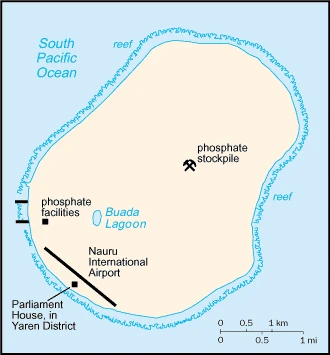
A single low-lying coral atoll with a fertile coastal belt. Coral cliffs encircle an elevated interior plateau.
Nauru lies in the Pacific, northeast of Australia. Phosphate deposits gave its inhabitants huge temporary wealth, but economic mismanagement has left them facing ruin.
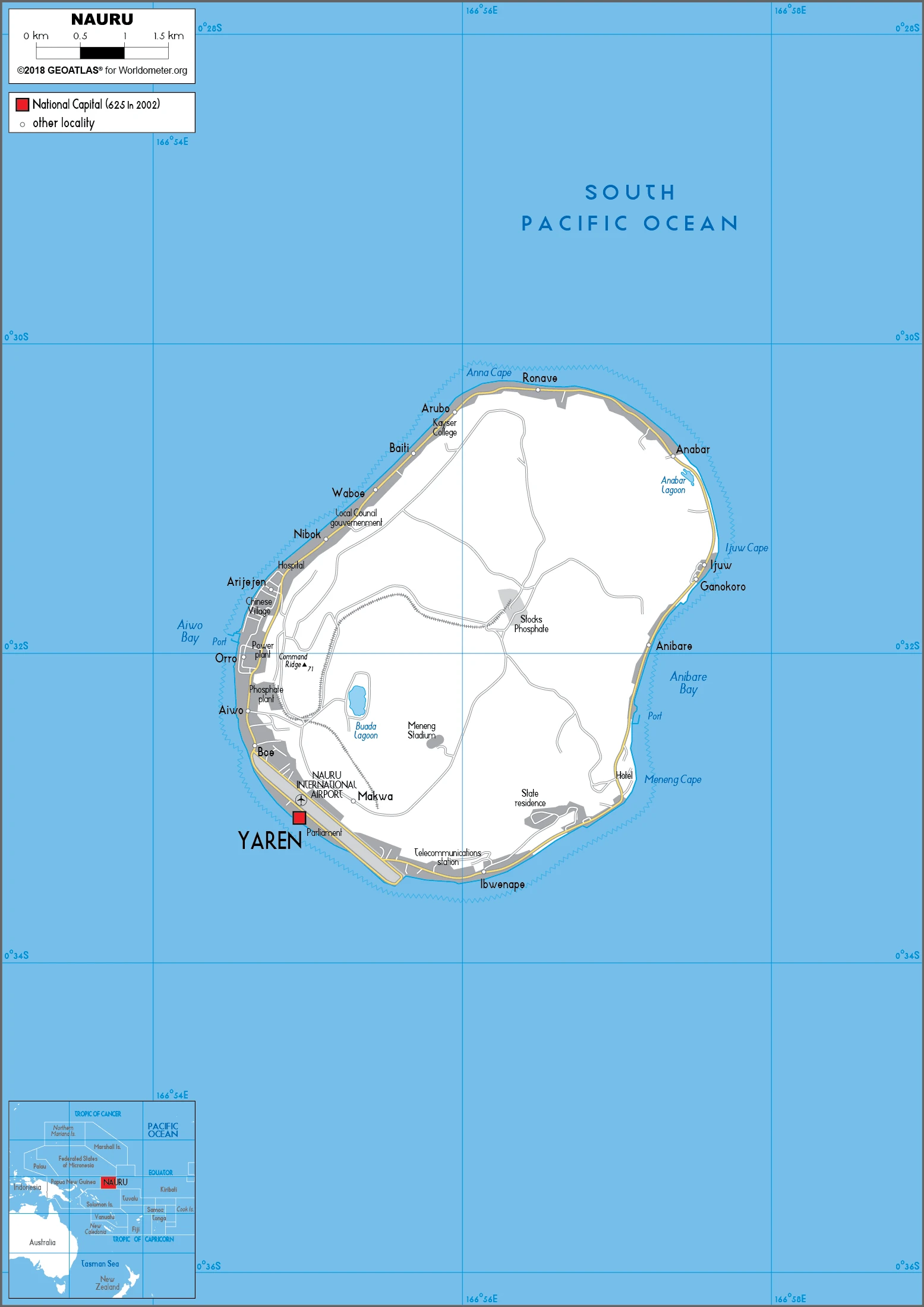
This state is located in Oceania, an island in the South Pacific Ocean, south of the Marshall Islands, under the coordinates of 0 32 S, 166 55 E, covering an area of 21 sq km with a coastline of 30 km. Nauru is About 0.1 times the size of Washington, DC.
Sandy beach rises to a fertile ring around raised coral reefs with a phosphate plateau in the center, with Command ridge 70 m as the highest point of Nauru, while Pacific Ocean 0 m as the lowest point. With a total of 21 sq km, Nauru has 21 sq km of land and 0 sq km of water surface area.
Nauru is the third-smallest country in the world behind the Holy See (Vatican City) and Monaco; it is the smallest country in the Pacific Ocean, the smallest country outside Europe, the world’s smallest island country, and the world’s smallest independent republic; situated just 53 km south of the Equator, Nauru is one of the three great phosphate rock islands in the Pacific Ocean – the others are Banaba (Ocean Island) in Kiribati and Makatea in French Polynesia.
The climate in Nauru is as follows: Tropical with a monsoonal pattern, rainy season (November to February).
When visiting Nauru, the natural hazards shall be considered: Periodic droughts.
The following major health-threatening issues shall be considered when visiting Nauru: degree of risk: high (2020), bacterial diarrhea, malaria.
Current environmental issues affecting the Nauruan people: limited natural fresh water resources, roof storage tanks that collect rainwater, and desalination plants provide water; a century of intensive phosphate mining beginning in 1906 left the central 90% of Nauru a wasteland; cadmium residue, phosphate dust, and other contaminants have caused air and water pollution with negative impacts on health; climate change has brought on rising sea levels and inland water shortages.
Google Maps Nauru
The capital and other divisions
Capital city: no official capital; government offices in the Yaren District found, applying the time zone UTC+12 (17 hours ahead of Washington, DC, during Standard Time), using the following daylight saving time: none.
There are many interesting things about Nauru, but the capital is not one. In fact, it doesn’t really have capital. Nauru is a phosphate-rich island nation in the South Pacific Ocean. It is one of the smallest countries globally, with an area of only 21 square miles. In 1968, Nauru attained independence from Australia as an internally self-governing state.
Nauru became independent on 31 January 1968 (from the Australia-, NZ-, and UK-administered UN trusteeship), and its national holiday is Independence Day, 31 January (1968).
Administrative divisions: 14 districts; Aiwo, Anabar, Anetan, Anibare, Baitsi, Boe, Buada, Denigomodu, Ewa, Ijuw, Meneng, Nibok, Uaboe, Yaren.
People and society
Native Nauruans are of mixed Micronesian and Polynesian origin. Most live in simple, traditional houses and spend money on luxury cars and consumer goods. Welfare and education are free. A diet of imported processed foods has caused widespread obesity and diabetes. Mining was left to imported laborers, mainly from Kiribati, who lived in enclaves of male-only barracks and had few rights. Many young Nauruans leave to seek a better life in Australia or New Zealand.
The population in Nauru is 9,770 (July 2021 estimate), with an average of 0.42% (2021 estimate) change. That means Nauru is the No. 222 in the world’s populated rank list. With an average of 27 years median age (28.2 years for males and 28.2 years for women), Nauru ranks No. 150 on the globe’s median age rank list.
The people living in this country are the Nauruan(s) (noun) or Nauruan (adjective) and belong mainly to the following ethnic groups: Nauruan 88.9%, part Nauruan 6.6%, I-Kiribati 2%, other 2.5% (2007 estimate).
They speak Nauruan 93% (official language, a distinct Pacific Island language), English 2% (widely understood, spoken, and used for most government and commercial purposes), and other 5% (including I-Kiribati 2% and Chinese 2%) (2011 estimate). Note: data represent the main language spoken at home; Nauruan is spoken by 95% of the population, English by 66%, and other languages by 12% languages and practice the following religions: Protestant 60.4% (includes Nauru Congregational 35.7%, Assembly of God 13%, Nauru Independent Church 9.5%, Baptist 1.5%, and Seventh Day Adventist 0.7%), Roman Catholic 33%, other 3.7%, none 1.8%, unspecified 1.1% (2011 estimate).
We can conclude the following about the population in Nauru: Extensive phosphate mining made approximately 90% of the island unsuitable for farming. Most people live in the fertile coastal areas, especially along the southwest coast. In Nauru, we are talking about 100% (2021) of the total population is living in cities, and most of them reside in the following municipalities: N/A.
Industry
Phosphate revenues diminished. The sale of fishing rights only other resources. State trust fund invested badly overseas. Offshore banking facilities closed after international pressure.
Revenues of this tiny island – a coral atoll with a land area of 21 square kilometers – traditionally have come from exports of phosphates. Few other resources exist, with most necessities being imported, mainly from Australia, its former occupier and later major source of support. Primary reserves of phosphates were exhausted, and mining ceased in 2006, but mining of a deeper layer of secondary phosphate in the island’s interior began the following year. The secondary phosphate deposits may last another 30 years. Earnings from Nauru’s export of phosphate remain an important source of income. Few comprehensive statistics on the Nauru economy exist; estimates of Nauru’s GDP vary widely. The rehabilitation of mined land and the replacement of income from phosphates are serious long-term problems. In anticipation of the exhaustion of Nauru’s phosphate deposits, substantial amounts of phosphate income were invested in trust funds to help cushion the transition and provide for Nauru’s economic future., Although revenue sources for the government are limited, the opening of the Australian Regional Processing Center for asylum seekers in 2012 has sparked economic growth. Revenue derived from fishing licenses under the vessel day scheme has also boosted government income. Housing, hospitals, and other capital plant are deteriorating. The cost to Australia of keeping the Nauruan government and economy afloat continues to climb.
Nauru is rich in the following natural resources: Phosphates, fish.
The main industrial sectors are phosphate mining, offshore banking, and coconut products.
The country’s export sectors are particularly strong in fish, calcium phosphates, low-voltage protection equipment, air conditioners, leather apparel (2019), partnering with these nations: Thailand 34%, Australia 16%, United States 13%, South Korea 10%, Philippines 9%, Japan 7%, France 5% (2019). The export trade resulted in $30 million. Note: Data are in current year dollars (2018 estimate). In a global rank of the export, values resulted in Nauru’s position of 216.
Land use in Nauru: 0% (2018 estimate) forest, 80% (2018 estimate) other.
The arable land area is 0% (2018 estimate), and the agricultural land is 20% (2018 estimate). Land use for permanent crops 20% (2018 estimate), permanent pasture 0% (2018 estimate). The sum of the area of the irrigated land is 0 sq km (2012).
The main agro-industrial products of Nauru are coconuts, tropical fruit, vegetables, pork, eggs, pig offals, pig fat, poultry, papayas, and cabbages.
The country typically needs to import: refined petroleum, construction vehicles, tug boats, poultry meats, cars (2019), partnering with the following nations: Taiwan 52%, Australia 28% (2019) in a sum value of $90 million. Note: data are in current year dollars (2018 estimate) $64.9 million (2016 estimate). This sum value on the global ranking list of imports resulted in Nauru 220.
Nauru Driving Directions
In this post, you learned about Nauru, Oceania, an island in the South Pacific Ocean, south of the Marshall Islands. We published basic information about its capital, no official capital, government offices in the Yaren District, and the Nauruan nation.
Are you interested in visiting Nauru and looking for driving directions? Click here to plan your route, or see a printable road map of Nauru below for an overview of the route network.
Printable map of Nauru
Did you know about Nauru?
Nauru has gained some notoriety because of its phosphate mines. In fact, until recently, it was one of the richest countries in the world. However, when 95% of the resources were depleted, it became one of the poorest countries in the world.
After virtually visiting Nauru, you may also be interested in the neighboring countries: none.
If you liked our Google map and Nauru information page,
please share it with others or save the link https://www.drivingdirections.net in your bookmarks.