
Ethiopia Google Maps is a site/tool that offers a wide range of map views (topographic, satellite, street view) and navigation options, with little effort on your part, yet efficiently. If you need to plan a trip to a new place like Ethiopia, Google maps are available on desktop, mobile, or tablet. This Google maps and information page is dedicated to Ethiopia, Africa (54 countries), showing its location, country facts, details about its capital city Addis Ababa, bordering countries like Djibouti, Eritrea, Kenya, Somalia, South Sudan, Sudan, and plenty of other information which may be interesting when you visit this African state.
Quick links: Google Maps Ethiopia, Addis Ababa Google maps, Driving Directions Ethiopia, Printable Road Map.
About Ethiopia in a nutshell
- King Solomon and the Queen of Sheba are said to have founded the Kingdom of Abyssinia (Ethiopia) c. 1000 BCE.
- Conventional short form of the name: Ethiopia
- The conventional long form of the name: Federal Democratic Republic of Ethiopia
- Local long form: Ityopiya Federalawi Demokrasiyawi Ripeblik
- Local short form: Ityopiya
- Former name(s): Abyssinia, Italian East Africa
- Etymology: the country name derives from the Greek word Aethiopia, which in classical times referred to lands south of Egypt in the Upper Nile region.
- The legal system in Ethiopia: civil law system.
- Climate: Moderate, with summer rains. Highlands are warm, with night frost and snowfalls on the mountains.
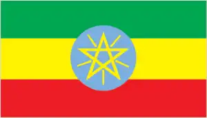
- The national symbols are Abyssinian lion (traditional), yellow pentagram with five rays of light on a blue field (promoted by current government); national colors: green, yellow, red.
- Internet TLD: .et
Background
Unique among African countries, the ancient Ethiopian monarchy maintained its freedom from colonial rule except for a short-lived Italian occupation from 1936-41. In 1974, a military junta deposed Emperor Haile SELASSIE (who had ruled since 1930) and established a socialist state. Torn by bloody coups, uprisings, wide-scale drought, and massive refugee problems, the regime was finally toppled in 1991 by a coalition of rebel forces, the Ethiopian People’s Revolutionary Democratic Front (EPRDF). A constitution was adopted in 1994, and Ethiopia’s first multiparty elections were held in 1995. A border war with Eritrea in the late 1990s ended with a peace treaty in December 2000. In November 2007, the Eritrea-Ethiopia Border Commission (EEBC) issued specific coordinates as virtually demarcating the border and pronounced its work finished. Alleging that the EEBC acted beyond its mandate in issuing the coordinates, Ethiopia did not accept them. It maintained troops in previously contested areas pronounced by the EEBC as Eritrea. This intransigence resulted in years of heightened tension between the two countries.
In August 2012, longtime leader Prime Minister MELES Zenawi died in office and was replaced by his Deputy Prime Minister HAILEMARIAM Desalegn, marking the first peaceful transition of power in decades. Following a wave of popular dissent and anti-government protest in 2015, HAILEMARIAM resigned in February 2018, and ABIY Ahmed Ali took office in April 2018 as Ethiopia’s first ethnic Oromo prime minister. In June 2018, ABIY announced Ethiopia would accept the border ruling of 2000, prompting rapprochement between Ethiopia and Eritrea marked with a peace agreement in July 2018 and a reopening of the border in September 2018. In November 2019, Ethiopia’s nearly 30-year ethnic-based ruling coalition – the EPRDF – merged into a single unity party called the Prosperity Party. However, one of the four constituent parties (the Tigray Peoples Liberation Front or TPLF) refused to join.
Geography
Great Rift Valley divides the mountainous northwest region from desert lowlands in the northeast and southeast. Ethiopian Plateau is drained mainly by the Blue Nile.
Ethiopia is tremendous natural beauty, with a history rich in unique traditions and cultures. Ethiopia is also one of the world’s poorest countries, with only 8% of its population having access to electricity.
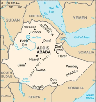
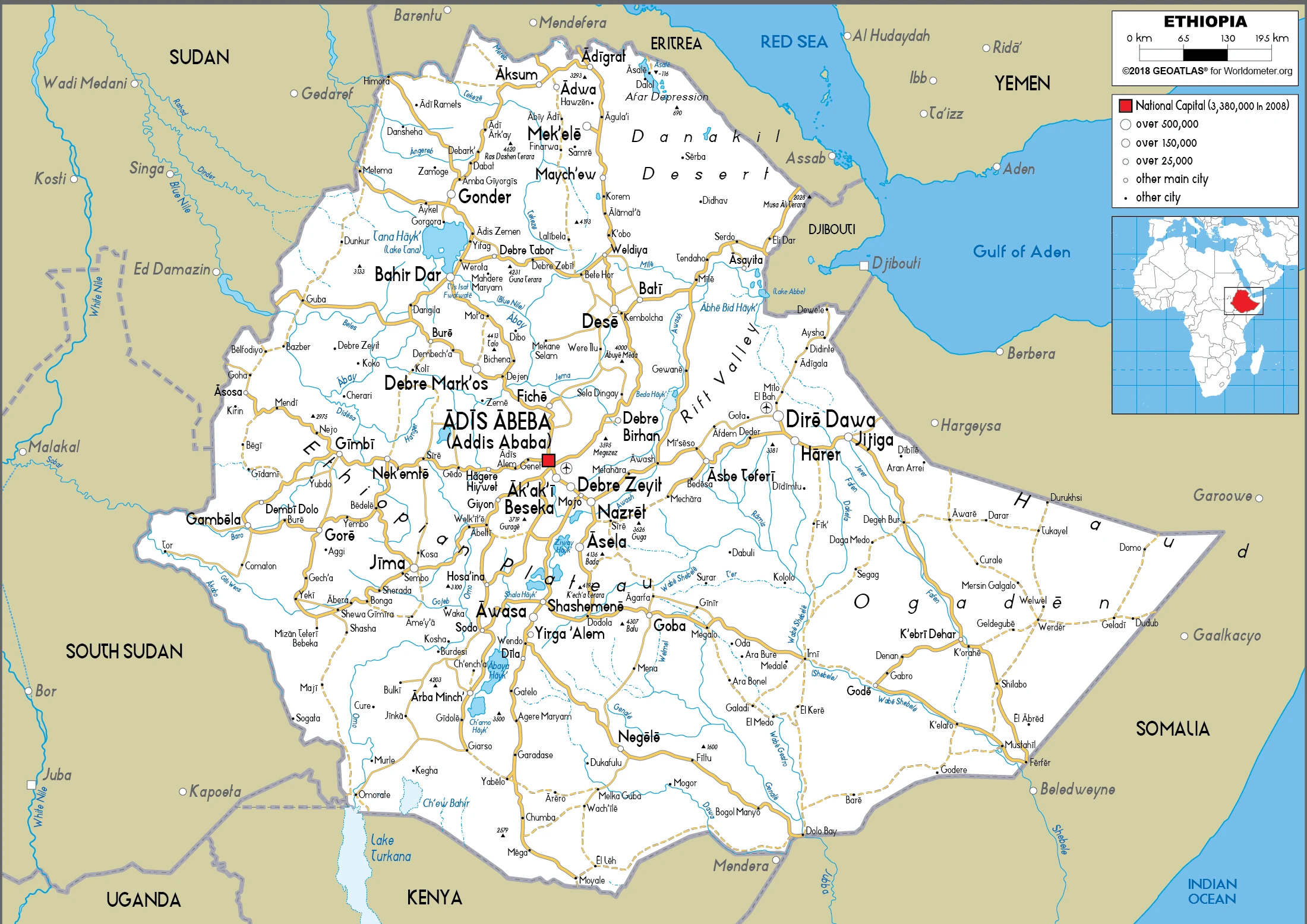
This state is located in Eastern Africa, west of Somalia, under the coordinates of 8 00 N, 38 00 E, covering an area of 1,104,300 sq km with a coastline of 0 km (landlocked country). Ethiopia is Slightly less than twice the size of Texas.
Ethiopia has 5,925 km of land boundaries in total, and bordering with (6 nations): Djibouti 342 km, Eritrea 1033 km, Kenya 867 km, Somalia 1640 km, South Sudan 1299 km, Sudan 744 km.
High plateau with central mountain range divided by the Great Rift Valley, with Ras Dejen 4,550 m as the highest point of Ethiopia, while Danakil Depression -125 m as the lowest point, causing a mean elevation at 1,330 m throughout the country. With a total of 1,104,300 sq km, Ethiopia has 1,096,570 sq km of land and 7,730 sq km water surface area.
Major water bodies in the country: Lago de Izabal – 590 sq km (a freshwater lake), Laguna de Caratasca – 1,110 sq km (saltwater lake), while the major rivers are: Blue Nile river source (shared with Sudan m) – 1,600 km. The significant watersheds for Ethiopia are Atlantic Ocean drainage: (Mediterranean Sea) Nile (3,254,853 sq km) France Atlantic Ocean drainage: Loire (115,282 sq km), Seine 78,919 sq km), Rhine-Maas (198,735 sq km), (Adriatic Sea) Po (76,997 sq km), (Mediterranean Sea) Rhone (100,543 sq km).
Landlocked – entire coastline along the Red Sea was lost with the de jure independence of Eritrea on 24 May 1993; Ethiopia is, therefore, the most populous landlocked country in the world; the Blue Nile, the chief headstream of the Nile by water volume, rises in Tana Hayk (Lake Tana) in northwest Ethiopia
The climate in Ethiopia is as follows: Tropical monsoon with a wide topographic-induced variation.
When you visit Ethiopia, the natural hazards shall be considered: Geologically active great rift valley susceptible to earthquakes, volcanic eruptions; frequent droughts volcanism: volcanic activity in the Great Rift Valley; Erta ale (613 m), which has caused frequent lava flows in recent years, is the country’s most active volcano; Dabbahu became active in 2005, forcing evacuations; other historically active volcanoes include Alayta, Dalaffilla, Dallol, Dama Ali, Fentale, Kone, Manda Hararo, and Manda-Inakir.
The following major health-threatening issues shall be considered when visiting Ethiopia: degree of risk: very high (2020), bacterial and protozoal diarrhea, hepatitis A, typhoid fever, malaria, dengue fever, schistosomiasis, rabies, meningococcal meningitis.
Current environmental issues affecting the Ethiopian people: deforestation, overgrazing; soil erosion; desertification; loss of biodiversity; water shortages in some areas from water-intensive farming and poor management, industrial pollution, and pesticides contribute to air, water, and soil pollution.
Google Maps Ethiopia
The capital and other divisions
Capital city: Addis Ababa found under the coordinates 9 02 N, 38 42 E, applying the time zone UTC+3 (8 hours ahead of Washington, DC, during Standard Time), using the following daylight saving time: none.
Addis Ababa is the capital and largest city of Ethiopia. It is located near the district with the same name in northwestern Ethiopia. It was founded in 1887 by Menelik II, then king of Shewa (which Addis Ababa later became), as a fortified encampment to protect against attack from neighboring Oromo tribes.
Ethiopia became independent on the oldest independent country in Africa and one of the oldest in the world – at least 2,000 years (maybe traced to the Aksumite Kingdom, which coalesced in the first century B.C.), and its national holiday is Derg Downfall Day (defeat of MENGISTU regime), 28 May (1991).
Administrative divisions: 10 ethnically based regional states (kililoch, singular – kilil) and 2 self-governing administrations (astedaderoch, singular – astedader); Adis Abeba (Addis Ababa), Afar, Amara (Amhara), Binshangul Gumuz, Dire Dawa, Gambela Hizboch (Gambela Peoples), Hareri Hizb (Harari People), Oromiya (Oromia), Sidama, Sumale (Somali), Tigray, Ye Debub Biheroch Bihereseboch na Hizboch (Southern Nations, Nationalities and Peoples).
People and society
76 Ethiopian nationalities speak 286 languages. Oromo (or Gallas) are the largest group. Ethnic representation is a major political issue. Orthodox Christianity has a very ancient history in Ethiopia. Former emperor Haile Selassie inspired Rastafarianism.
The population in Ethiopia is 110,871,031 (July 2021 estimate). Note: estimates for this country explicitly take into account the effects of excess mortality due to AIDS; this can result in lower life expectancy, higher infant mortality, higher death rates, lower population growth rates, and changes in the distribution of the population by age and sex than would otherwise be expected, with an average of 2.5% (2021 estimate) change. That means Ethiopia is the No. 12 in the world’s populated rank list. With an average of 19.8 years median age (19.6 years for males and 19.6 years for women), Ethiopia ranks No. 197 on the globe’s median age rank list.
The people living in this country are the Ethiopian(s) (noun) or Ethiopian (adjective) and belong mainly to the following ethnic groups: Oromo 34.9%, Amhara (Amara) 27.9%, Tigray (Tigrinya) 7.3%, Sidama 4.1%, Welaita 3%, Gurage 2.8%, Somali (Somalie) 2.7%, Hadiya 2.2%, Afar (Affar) 0.6%, other 12.6% (2016 estimate).
They speak Oromo (official language working language in the State of Oromiya) 33.8%, Amharic (official language national language) 29.3%, Somali (official language working language of the State of Sumale) 6.2%, Tigrigna (Tigrinya) (official language working language of the State of Tigray) 5.9%, Sidamo 4%, Wolaytta 2.2%, Gurage 2%, Afar (official language working language of the State of Afar) 1.7%, Hadiyya 1.7%, Gamo 1.5%, Gedeo 1.3%, Opuuo 1.2%, Kafa 1.1%, other 8.1%, English (primary foreign language taught in schools), Arabic (2007 estimate). Major-language sample(s): Kitaaba Addunyaa Waan Qabataamaatiif – Kan Madda Odeeffannoo buuraawaatiif baayee barbaachisaa tae languages, and the Ethiopian people mainly practice the following religions: Ethiopian Orthodox 43.8%, Muslim 31.3%, Protestant 22.8%, Catholic 0.7%, traditional 0.6%, other 0.8% (2016 estimate).
We can conclude the following about the population in Ethiopia: Highest density is found in the highlands of the north and central areas of the country, particularly around the centrally located capital city of Addis Ababa. The far east and southeast are sparsely populated, as shown in this population distribution map. In Ethiopia, we are talking about 22.2% (2021) of the total population is living in cities, and most of them reside in the following municipalities: 5.006 million, Addis Ababa (capital city) (2021).
Industry
Overwhelmingly dependent on agriculture, coffee is the main export crop. War-damaged infrastructure and periodic severe droughts and famines undermine growth. There is a heavy reliance on food aid. Landlocked since the secession of Eritrea.
Ethiopia – the second most populous country in Africa – is a one-party state with a planned economy. For more than a decade before 2016, GDP grew between 8% and 11% annually , one of the fastest-growing states among the 188 IMF member countries. This growth was driven by government investment in infrastructure and sustained progress in the agricultural and service sectors. More than 70% of Ethiopia’s population is still employed in the agricultural sector, but services have surpassed agriculture as the principal source of GDP. Ethiopia has the lowest level of income-inequality in Africa and one of the lowest globally, with a Gini coefficient comparable to that of the Scandinavian countries. Yet despite progress toward eliminating extreme poverty, Ethiopia remains one of the poorest countries in the world due both to rapid population growth and a low starting base. Changes in rainfall associated with worldwide weather patterns resulted in the worst drought in 30 years in 2015-16, creating food insecurity for millions of Ethiopians.
The state is heavily engaged in the economy. Ongoing infrastructure projects include power production and distribution, roads, rails, airports, and industrial parks. Key sectors are state-owned, including telecommunications, banking and insurance, and power distribution. Under Ethiopia’s constitution, the state owns all land and provides long-term leases to tenants. In urban areas, particularly Addis Ababa, Title rights are poorly regulated and subject to corruption. The services sector leads Ethiopia’s foreign exchange earnings – primarily the state-run Ethiopian Airlines – followed by exports of several commodities. While coffee remains the largest foreign exchange earner, Ethiopia diversifies exports, and commodities such as gold, sesame, khat, livestock, and horticulture products are becoming increasingly important. Manufacturing represented less than 8% of total exports in 2016, but manufacturing exports should increase in future years due to a growing international presence.
The banking, insurance, telecommunications, and micro-credit industries are restricted to domestic investors, but Ethiopia has attracted roughly $8.5 billion in foreign direct investment (FDI), mainly from China, Turkey, India, and the E.U.; US FDI is $567 million. Investment has been primarily in infrastructure, construction, agriculture/horticulture, agricultural processing, textiles, leather, and leather products. To support industrialization in sectors where Ethiopia has a comparative advantage, such as textiles and garments, leather goods, and processed agricultural products, Ethiopia plans to increase installed power generation capacity by 8,320 MW, up from a capacity of 2,000 MW, by building three more major dams and expanding to other sources of renewable energy. In 2017, the government devalued the birr by 15% to increase exports and alleviate a chronic foreign currency shortage in the country.
Ethiopia is rich in the following natural resources: Small reserves of gold, platinum, copper, potash, natural gas, hydropower.
The main industrial sectors are typically food processing, beverages, textiles, leather, garments, chemicals, metals processing, cement.
The country’s export sectors are particularly strong in coffee, sesame seeds, gold, cut flowers, zinc (2019), partnering with these nations: China 17%, United States 16%, United Arab Emirates 8%, Saudi Arabia 6%, South Korea 5%, Germany 5% (2019). The export trade resulted in $7.62 billion. Note: Data are in current year dollars (2018 estimate). In a global rank of the export, values resulted in Ethiopia’s position of 109.
Land use in Ethiopia: 12.2% (2018 estimate) forest, 51.5% (2018 estimate) other.
The arable land area is 15.2% (2018 estimate), and the agricultural land is 36.3% (2018 estimate). Land use for permanent crops 1.1% (2018 estimate), permanent pasture 20% (2018 estimate). The sum of the area of the irrigated land is 2,900 sq km (2012).
The main agro-industrial products of Ethiopia are maize, cereals, wheat, sorghum, milk, barley, sweet potatoes, roots/tubers nes, sugar cane, millet.
The country typically needs to import: aircraft, gas turbines, packaged medicines, electric filament, cars (2019), partnering with the following nations: China 27%, India 9%, United Arab Emirates 9%, France 9%, United Kingdom 7% (2019) in a sum value of $19.93 billion. Note: data are in current year dollars (2018 estimate) $14.69 billion (2016 estimate). This sum value on the global ranking list of imports resulted in Ethiopia 83.
Ethiopia Driving Directions
In this post, you learned about Ethiopia, Eastern Africa, west of Somalia. We published some basic information about its capital Addis Ababa, and the Ethiopian nation.
Are you interested in visiting Ethiopia and looking for driving directions? Click here to plan your route, or see a printable road map of Ethiopia below for an overview of the route network.
Printable map of Ethiopia
Did you know about Ethiopia?
Ethiopia is one of the oldest countries in Africa. It was around 3000 years ago people began to live in this area. They were Africans like the rest of us, and they had the same customs as African people today. It wasn’t until the late 1800s that Europeans conquered Ethiopia. The Ethiopian empire collapsed, and Europeans made Ethiopia a colony for around 100 years before deciding to make it a nation-state again in 1941.
After virtually visiting Ethiopia, you may also be interested in the neighboring countries: Djibouti, Eritrea, Kenya, Somalia, South Sudan, Sudan.
If you liked our Google map and Ethiopia information page,
please share it with others or save the link https://www.drivingdirections.net in your bookmarks.